
The Hanging Rock Iron Region comprised an area of country
embracing more than 1,000 square miles, extending into the States
of Kentucky and West Virginia, and Scioto, Lawrence, Jackson and
Vinton counties in Ohio, with its center at Ironton. This vast
mineral region contained valuable iron ores, large and accessible
deposits of coal, limestone and fire-clays.
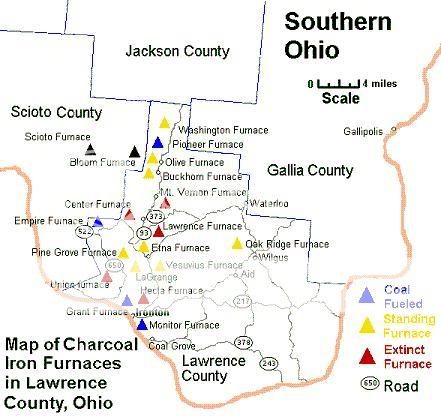
Hanging Rock Iron Region had the honor of being the site of the
first major expansion of iron manufacturing in the United States.
This was due to the discovery of a bonanza of iron ore in the early
1800s. The ferriferous iron ore, often a foot thick, laid
immediately on top of iron rich limestone. Outcroppings along the
hillsides led to easy discovery of this important element. It was
much more than heretofore had been found anywhere in the
continental United States.
Geologists say that the purity of the iron ores in this district
were attributable to the fact that the plane of the veins or
"horizons" laid far enough above the general water level to drain
the water that accumulated from the rain fall, through the minerals
and out into the streams. The dip of the strata is reported to be
about 30 feet to the mile to the south of east giving the
inclination of all coal and ore horizons a rapid fall in the
direction of the dip. This made it possible for miners to run all
material out on tram tracks by gravitation, as well as to get rid
of the water without expense.
The Hanging Rock ores were peculiarly adapted to the production
of an iron of great strength and durability. They were said to be
of the red hematite variety-the "hilltop" ores being largely used
with underlying limestone ore. Furnace Managers recognized several
important seams of ore here in well known and consistent horizons
that followed the margin of the coal horizons recorded from early
geologic surveys. The ferriferous limestone was rated high in value
and persistency.
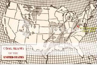
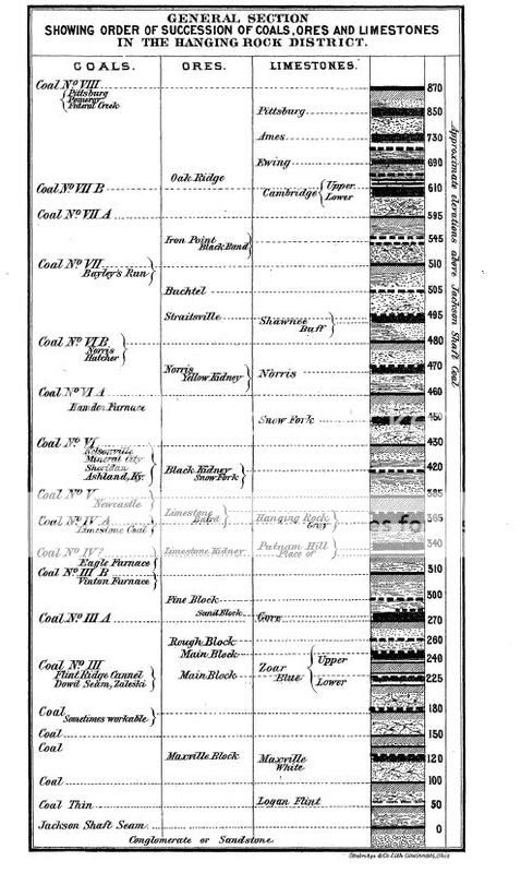
The coal seams were valuable guides in following the horizons
from point to point. When the limestone, coal and ore were all
brought into horizontal alignment for miles without interruption,
their symmetrical order was pronounced. The coal measures of Ohio
are important sources of iron ore and fire-clay as well as of coal,
as is true of coal measures generally. Iron ore was mined in the
Ohio coal-fields at a dozen or more horizons, but there are three
or four that monopolize most of the interest and importance. The
ferriferous limestone ore of the Hanging Rock district was a thin
but valuable seam. The iron manufactured from it has unusual
strength and excellence and was applied to the highest uses.
The ores of the Hanging Rock Region can be divided
stratigraphically into three natural groups. The lowest horizon
extends from the Carboniferous Period and is a limestone used as
block ore. The second division is the ferriferous limestone horizon
which is a central feature of the whole district. The third horizon
is the sandstone which extends some 150' above the limestone in
most of the region. The coal horizons can be followed southward and
westward from the Pennsylvania line and can be traced with
unmistakable distinctness from Jackson County into Scioto and
Lawrence Counties to the Ohio River.The limestone horizon was by
far the most important one of the series and is one of the most
well marked and persistent features of the geology of the Hanging
Rock Region.
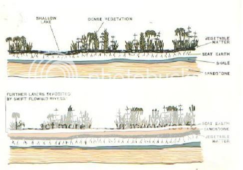
The native iron ores that account for the success of the
furnaces of the region are derived from the Lower Coal Measures and
accumulated under the same general conditions- as carbonates of
iron in the marshes and swamps of the Carboniferous Period during
Mississippian and Pennsylvanian Periods of the Paleozoic Era. They
were stratified or concretionary or chemical formed ores. The coals
formed near sea level. The fossil filled limestone formed upon the
sea floor in warm and clear water. Sandstones comprise the flesh
and bones of decaying animals and were of deltaic deepwater
creation.
The lowest deposit of ore is generally found near the lowest
coal seam. The lowest coal seam or horizon here was
Sub-Carboniferous Period Age. The limestone horizon will follow the
coal seams intermittently throughout the horizon. Sandstone
generally lies at the top of formations from creation during deeper
water conditions. The most pronounced coal seam on the geologic
horizon in Southern Ohio is the #6 Coal. Valuable fire clay
generally was heavily underlain by Coal #3 seams.
The ores of the Coal Measures are of great economic importance
and have been called the "economic horizons" geologically. The
horizon formations can be traced with the eye in unbroken outcrop
for mile after mile here. They include sandstone ledges, beds of
coal, flint and fire clay, and seams of ore and limestone strata.
The heavy sandstone that covers Coal #6 throughout the region
outcrop is very visible along the Ohio River. Near the Village of
Hanging Rock it shows itself in a bold and picturesque escarpment
that time has weathered in the form of a rock overhang from which
the village derived it's name.
The coal horizons are perhaps the most trusted and used in
marking other horizons. Reliance in their quality are generally
found to be consistent. Similarly with the fire clays. It is with
the limestone horizon that difference in quality can be found. The
limestone tend to be more individualized by region. Thus
distinguishing the Hanging Rock Region for great quality for the
production of iron when other locations of similar time and period
limestone was not as good quality.
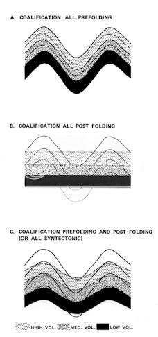
Geologic studies in the Appalachian region have shown that many
parameters of coal beds (thickness and continuity, sulfur and
trace-element content, and ash) can be attributed to the
depositional environment in which the peat beds formed and to the
tectonic setting at the time of deposition. With an understanding
of the depositional setting of the coal seam and contemporaneous
tectonic influences, the characteristics and variability of many of
these parameters can be predicted.
Coals formed in "back-barrier" environments tend to be thin,
laterally discontinuous and high in sulfur. Coal beds deposited in
the "lower delta-plain" environment are relatively widespread with
but generally are thin and show a highly irregular pattern of
sulfur and trace-element distribution. Conversely, "upper delta
plain-fluvial" coals are low in sulfur, are thick locally, but are
commonly discontinuous laterally. However, most important seams in
the Appalachian area are in the transitional zone between these two
environmental settings. In this transition zone thick coals attain
a relatively high degree of lateral continuity and are usually low
in sulfur.
Contemporaneous tectonic influences are superposed on changes in
seam character attributed to variations in environments of
deposition. Rapid subsidence during sedimentation generally results
in abrupt variations in coal seams but favors lower sulfur and
trace-element content, whereas slower subsidence favors greater
lateral continuity but higher content of chemically precipitated
material.
The iron ores were sought diligently for the capabilities of the
Lower Coal Measures to furnish a proper supply for the charcoal
furnaces. However, no similar measure led to like development of
the coal seams. Ironic, as the coal fired furnaces were the ruin of
the charcoal furnaces. As forests disappeared and the ability to
create charcoal dwindled with the resources, the furnaces in the
lake Superior area developed the coal technology that changed the
way iron was produced.
How appropriate it is that you travel to Rock Avenue in Hanging
Rock to make the following calculations for this earth cache. You
will want to take note of the coal seams that run through the
horizons of the formation here at the road cut.

Answer the questions below and email them to us. Take a picture
of the rock cut with your GPS in the shot to post.
1. How many seams of coal can be identified from bottom to top
on the rock cut?
a. 2 b. 3 c. 4
2. Estimate how many horizons (Layers) of coal and other ore
(sandstone, limestone, clay) comprise this formation from top to
bottom.
a. 3 b. 5 c. 7
3. Shoot an elevation at the road level exposure of the
formation.
At the end of the 19th Century, the Hanging Rock Iron Region
began to fade away and the furnaces were blown out. Many furnaces
lie in ruin now.

Bigger furnaces capable of producing greater quantities more
efficiently through new technology saw the region's demise. 80
furnaces once dotted the 100 mile long 30 mile wide ore rich
region. Today there are only ruins and stories of what once was.
The area is still remembered as being the location of "where coal
met iron".
