10/4/08 Update: MetroParks has cleared the trail leading to the cache. I'll check with them and see what they are doing. Maybe a future foot bridge across the river??? Anyway, a huge tree has fallen across the path. Mrs. Amazing and I were able to navigate around. However, proceed with caution. Also, I cleared away the poison ivy around the cache location. The final retrieval is a little tricky so please be careful!
1/27/16 update: The cache was relocated due to constant flooding in the area. Terrain and difficulty remain the same.

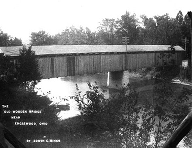
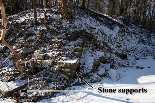
Englewood was founded by settlers from Harrisburg, Pennsylvania in 1841 and was originally named Harrisburg, Ohio. The town was a major stopping point along the old National Trail for settlers heading west in the 1840s and thereafter. Travelers coming from eastern states would cross the old covered bridge over the Stillwater River and could spend the night at the Becker hotel that was on the corner of what is now Main Street (SR 48) and National Road (SR40). Many travelers liked the fertile farmlands, forests and abundant water supplies in this area and decided to take up residence. Later, National Road was designated as Route 40 and continued to carry a large number of travelers. The road was re-routed over the Englewood Dam in 1922 and the old wooden bridge was removed. The old road to the river and the stone supports you see today are all that remains of this fascinating piece of history.
Fun Fact: Why the Name 'Northmont'? You'll frequently hear this area (which includes Englewood, Union, Clayton, and Phillipsburg) called 'Northmont.' The name was coined in 1960 by a schoolgirl, Patty Bowser, who combined 'northern' and 'Montgomery,' winning a contest to name what was then our newly formed school district.
For more information visit the Randolph Township Historical Society at www.rths.org
Congratulations to RyanWalk325, Jamesguinn, theologicalprankster and flyfish1231 for making this their first find!
Cache with confidence! This cache was placed with permission from Kelly Kingery, Recreation Department, Five Rivers MetroParks.
Important notes:
Look for the cache in daylight hours only. A gravel pull-off for parking is available just outside the park entrance. Coordinates are N 39 52.700 W 084 17.976. Please begin the hiking trail at the single (locked) gate. No off trail buskwacking is required.
The unestablished trail leading to the cache is less than two tenths of a mile one way. It is not maintained and has inclines, fallen trees and protruding rocks. You will need to use bug spray during the warmer months. Please hike with care. Also, please exercise extreme caution when standing at Ground Zero. Young children SHOULD NOT get close to Ground Zero!
The old cut stone supports are approximately twenty yards past the cache and can be reached by descending a short steep hill to the river (N 39 52.790, W 084 17.789). If you chose to descend please do so at your own risk. Better yet, just view the photo of the old stone supports below and skip the descent. Enjoy!
