Holes In The Devil
WARNING!: You must be in good
physical condition to attempt this cache. The trail is steep and
the rocks can be slippery.
You will need:
-
Your Camera
-
A measuring tape
Devil's
Lake State Park’s bluffs are part of the Baraboo Range, which
scientists believe were formed 1.6 billion years ago, making them
one of the most ancient rock outcrops in North America.
These
ancient hills are formed of quartzite rock, which consists of
grains of sand tightly cemented together.
According
to geologists, the sand was deposited by rivers as they drained
into shallow seas covering this area a billion years ago. As the
sand accumulated, it first formed sandstone (a porous sedimentary
rock) and then, under great heat and pressure, became quartzite (a
non-porous metamorphic rock).
The Ranges
Rise
Some time
after the seas withdrew, the quartzite was buckled upwards in such
a way as to form the North Range and South Range, with a depression
between the ranges. The depression was filled with rocks softer
than quartzite.
The area
was then dry ground for a very long time. During this period, the
Baraboo Valley was formed as the soft deposits in the depression
eroded away. Many gorges were cut by running water during this
period.
Underwater
Again
Devil's
Doorway was created by water freezing and thawing in cracks in the
rock.
New seas
re-invaded this area and their sediments accumulated on the land
outside the Baraboo Hills, on the sides of the quartzite ranges, in
the gorges, and eventually on top of the Baraboo Hills. The gorges
were thus filled and the bluffs completely buried under sandy and
limey deposits.
After the
retreat of these seas, an ancient river or rivers removed most of
the sediments from the Baraboo Hills and the surrounding area, thus
exposing the quartzite bluffs again, and reopened the Lower Narrows
Gap and the Devil's Lake Gap (these gaps may have been partially
cut when the Baraboo Valley and the gorges were being formed).
Exposed
outcrops of the quartzite that weren't covered by the glacial ice
pack were subject to freezing and thawing conditions. Water seeping
into cracks in the quartzite expanded as it froze and eventually
broke pieces of the bluff away.
The thawing
and freezing cycles also formed the piles of broken rock called
talus on the slopes of the bluffs.
The Ice
Age
The final
chapter in this fascinating story took place about 15,000 years
ago, when a sheet of ice (the Wisconsin Glacier) crunched into this
area. The glacier covered the eastern half of the Baraboo Hills
with ice but not the western half. We know this because its
outermost boundary is marked by a ridge called a terminal moraine.
This ridge consists of rocks and gravel dropped by the glacier as
it stood and melted along this boundary.
The
Wisconsin Glacier rerouted the ancient river(s) elsewhere and
deposited dams of rocks and earth at the two open ends of the
Devil's Lake Gap. These damps are part of the terminal moraine.
Devil's Lake therefore is between two glacial "plugs" in an
abandoned valley of an ancient river.
If there
had not been a Wisconsin Glacier, presumably the ancient river(s)
would still be flowing through the Lower Narrows and Devil's Lake
gaps, and there would not be a Devil's Lake.
The lake is
spring-fed and varies in depth from 40 to 50 feet. It measures 500
feet from the lake to the top of the quartzite bluffs.
The
Task
From the
Potholes Trail that extends from the top of the East Bluff to the
beach area at the southeast end of Devils Lake you can see a number
of well-formed potholes. Stones moving within the bottom of a
long-lived river eddy drilled these cylindrical holes into the
quartzite along the walls of the gorge. Geologists do not know if a
glacial or preglacial river carved the potholes. It is known that
rivers flowing from glaciers do carry large amounts of coarse
sediment and commonly form potholes where they spill over bedrock.
Non glacial rivers can form potholes as well, however, and because
of no evidence that a glacier ever advanced to a position where it
could have spilled melt-water over East Bluff in the vicinity of
the potholes, it is thought it more likely formed by the preglacial
river that carved the gorge.
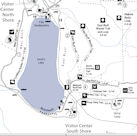
Ground Zero
can be reached from either the East Bluff Trail above or the
Grottos Trail from below. (see map, click for larger version)

Logging
Requirements:
#1
There is a pothole a few feet north of the coords that has some
initials in cement, email the diameter of the hole and the
initials.
(Please
do not post a picture that contains the initials)
AND
#2
Upload with your "Found it" log a photo at the pothole with your
GPS
Not meeting the logging requirements will
result in log deletion with out warning.
References:
Dott,
Robert H. Roadside Geology of Wisconsin. Missoula, MT:
Mountain Press, 2004
http://www.dnr.state.wi.us/org/land/parks/specific/devilslake/nature/geology.html
The Geocache Notification Form has been submitted to the
Wisconsin DNR. Geocaches placed on Wisconsin Department of Natural
Resource managed lands require permission by means of a
notification form. Please print out a paper copy of the
notification form, fill in all required information, then submit it
to the land manager. The DNR Notification form and land manager
information can be obtained at: http://www.wi-geocaching.com/hiding
Congratulations
to Bus42 for FTF and making it back alive!