GEOLOGY OF MARSHALL MESA OPEN SPACE
BOULDER, COLORADO
By
Sue Ellen Hirschfeld and Peter Stevenson
Volunteer Naturalists, City of Boulder Open Space and Mountain
Parks
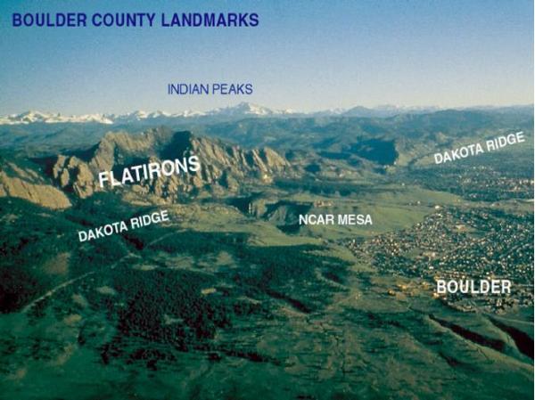
Figure 1. Location of prominent
landmarks seen from Marshall Mesa looking
west.
To log this EarthCache,
please send in an e-mail two stops which you find
particularly interesting. Briefly describe what you see at these
stops that directly indicates the geology described in this
guide.
Upload a photo of at least one person in you party at each of these
two stops, and include in your log the number of people in your
party.
Geologic History
As you look west, you see the high peaks (Indian Peaks) of the
Rocky Mountains and the tilted edges of the Flatirons and Dakota
Ridge. Prominent flat-topped surfaces (such as NCAR Mesa and Rocky
Flats to the south) are found to the east.
Let’s journey back in time, and see how the landscape of Boulder
Valley and the Front Range of Colorado has changed and how these
changing landscapes shaped the history of Marshall Mesa.
About 300 million years ago (mya) an earlier mountain range, called
the Ancestral Rocky Mountains, was uplifted. Sediments eroded from
the Ancestral Rockies were deposited by rivers flowing from the
mountains. The Flatirons are formed from these ancient deposits.
Over a period of nearly 200 million years, the Ancestral Rocky
Mountains were worn down, eroded away, and eventually buried under
sediments deposited along rivers and in lakes. At this time,
Boulder (now over 5000 feet elevation) was near sea level. Between
about 100 – 64 mya, ocean water from the Gulf of Mexico flooded
this area, eventually covered Colorado, and deposited thousands of
feet of mud and sand.
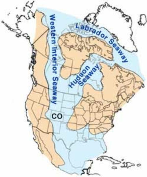
Figure 2. Western Interior Seaway flooded Colorado during the Upper
Cretaceous.
Then, beginning around 70 mya, the present
(Laramide) Rocky Mountains were uplifted and the sea retreated. As
the mountains rose, all the previously deposited sedimentary rocks
were tilted up against the rising mountains (creating the Flatirons
and the tilted rocks at Marshall Mesa – view geologic cross-section
at http://bcn.boulder.co.us/basin/watershed/geology/crosssec.html).
See
http://ci.boulder.co.us/files/openspace/pdf_education/Boulder_Sediments.pdf
for a detailed geologic/stratigraphic column for the rocks of
Boulder Valley and Marshall Mesa.
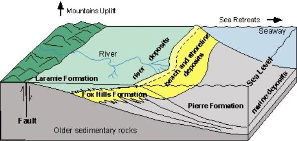
Figure 3. Depositional relationship of Upper Cretaceous
formations.
The rocks at Marshall Mesa record the beginning of uplift of the
Laramide (present) Rocky Mountains. As sediment was eroded from the
rising mountains, rivers carried the sediment to the inland sea.
Through time, a growing wedge of sediments built outward from the
mountain front causing the ocean to retreat eastward. Through time,
the Fox Hills Formation migrates eastward over the Pierre and the
Laramie Formation migrates eastward over the Fox Hills (where they
appear oldest to youngest in the stratigraphic column
http://ci.boulder.co.us/files/openspace/pdf_education/Boulder_Sediments.pdf.
In the diagram above, the (gray) Pierre Formation represents the
offshore, deeper water mud and sand. Today, approximately 7000 feet
of Pierre shale is found west of the Marshall Mesa Trailhead.
Pierre Formation underlies the “mesas” such as NCAR Mesa and Rocky
Flats. The Fox Hills Formation consists of fine to medium-grained
light-colored sandstone representing near-shore and beach deposits
(yellow in diagram above). The Laramie Formation is composed of
sandstone, shale, and coal beds (light green in diagram). The
Laramie is complex and represents a variety of coastal swamps and
estuaries near sea level. Coal that formed in these coastal swamps
was mined at Marshall Mesa and coal fields to the east. The climate
during Laramie deposition was very different from the dry one we
find in Colorado today. Plant fossils indicate that this part of
Colorado was subtropical with plenty of rainfall. To see what
Laramie plants looked like go to http://www.dmns.org/main/minisites/ancientDenvers/cden.html.
The Marshall Mesa area is cut by numerous faults (breaks along
which movement occurred) that run in a NE-SW direction. These
faults divide Marshall Mesa into a series of uplifted (horsts) and
down-dropped blocks (grabens). The faults may have been active
during the Laramide mountain building since some of the coal seams
are thicker in the grabens (Weimer, 1996).

Figure 4. Geologic Map of Marshall Mesa Open Space.
Before the uplift of the Laramide Rocky Mountain,
about 10,000 feet of sedimentary rock had been deposited over the
Ancestral Rocky Mountains. As the present Laramide Rocky Mountains
were uplifted, these softer sedimentary rocks were rapidly eroded
away, leaving harder granite and metamorphic rock forming the
“core” of the mountain range and the highest peaks. By about 45-50
mya, erosion had reduced the mountains and rivers carried
sediments, worn from the mountains, eastward across the Great
Plains spreading over eastern Colorado into Nebraska and Kansas,
forming extensive gravel deposits. In the last 5-10 million years,
deep steep-walled canyons have been cut into the Front Range. Most
recently, near the mountain front, rivers have been eroding these
younger deposits. South of Boulder, there is a high, broad,
gently-sloping surface called the Rocky Flats Surface. About 1-2
mya, Coal Creek (as it emerged from Coal Canyon) meandered across
this surface. In the process, it eroded older Pierre shale and
spread coarse gravel over the Rocky Flats surface (terrace). Many
of the large boulders and cobbles on Rocky Flats and Marshall Mesa
are composed of a blue-gray quartzite and metaconglomerate derived
from Coal Creek Canyon (quartzite and metaconglomerate are rocks
made of quartz sand and pebbles that were buried to considerable
depth where they were subjected to high temperature and pressure).
A series of lower surfaces (terraces) are found along South Boulder
Creek and its tributaries. These stair-stepped terrace sequences
may reflect climate changes during glacial and interglacial periods
during the last few hundred thousand years.
Note: GPS tour datum is all WGS84.
N 39° 57.158'
W 105° 13.881'
Marshall Mesa Open Space Trailhead:
Marshall Mesa is one of the parks in the City of Boulder Open Space
and Mountain Parks system. Please remember that collecting plants,
animals, or rocks is prohibited. To protect these fragile
resources, please stay on the trails.
On this hike we will travel back in time, peeking beneath the now
tranquil, grassy hillside to explore Marshall Mesa’s coal mining
and geologic history. We will be walking over the Upper Cretaceous
(about 68-70 million years old) Fox Hills and Laramie
Formations.
Marshall Mesa is situated at the western end of the Boulder-Weld
coalfield. Coal mining began at Marshall in 1863. This is one of
the oldest coal mining areas in the Western United States. Coal was
mined from the lower part of the Laramie Formation where coal seams
were 5-8 feet thick and only 30-40 feet below the ground surface.
Early mines were dug into seams exposed at the surface. Later,
tunnels were dug underground. The coal was not of particularly high
grade. However, it was in demand since it was close to the growing
cities of the Front Range. To read about the mining history read
Joanna Sampson’s “Walking Through History on Marshall Mesa” at
http://www.colorado.edu/physics/phys3070/phys3070_sp07/Reading/history_marshall_mesa.pdf.
As you walk the trails, you may find specific identification of the
Fox Hills and Laramie sandstones difficult to distinguish.
Generally, the sandstones that are well-exposed at the surface are
Laramie sandstones. The Fox Hills sandstones are less resistant and
form slopes covered with vegetation. Two exceptions are excellent
exposures of Fox Hills sandstone at the base of the “knob” on Pine
Ridge and along Community Ditch at Highway 93. Making
identification more complex, extensive faulting has disrupted the
original depositional relationships moving one formation higher or
lower, as we will see at the stops below.
DIRECTIONS TO STOPS AND LOCATIONS OF INTEREST ARE GIVEN IN
ITALICS.
This field guide follows the Marshall Valley Trail east (to the
left), then takes the Marshall Mesa Trail southwest up Pine Ridge
connecting to the west end of Community Ditch Trail and returns via
the lower part of the Coal Seam Trail (Loop “A”). These trails form
a loop approximately 2 miles long. An additional loop about a mile
long branches from the Community Ditch Trail to the Greenbelt
Plateau Trail to add a second loop (“B”) of about a mile. A trail
map can be obtained at:
http://www.bouldercolorado.gov/index.php?option=com_content&task=view&id=3073&Itemid=1922.
From the Trailhead, walk down the trail to the light-colored rock
outcrop paving the trail.
N 39° 57.132'
W 105° 13.862'
Stop 1. Laramie Formation sandstone: Here is a good exposure
of the Laramie sandstone. Run your fingers over the rock at your
feet. If you have a hand lens, look closely and you will see that
the rock is composed of grains of quartz sand cemented together.
The Laramie sandstone and beds of shale and coal were deposited in
swamps and along rivers flowing across a coastal plain near the
ocean. Within the sandstone (here and at other exposures along the
Marshall Valley Trail) you can find dark brown, iron-stained
concretions. These are very hard, rounded or irregular in shape,
and very resistant to weathering and erosion. The concretions were
formed after the sandstone was deposited as groundwater, containing
the iron, moved through the sandstone. The iron was then deposited
and concentrated in the concretions and along fractures in the
rock.
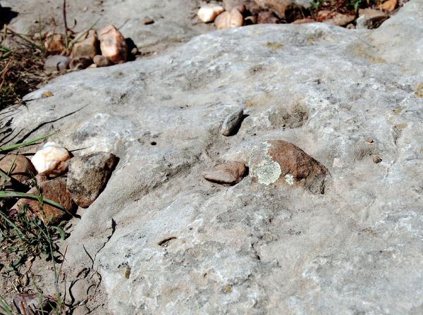
Figure 5. Ironstone concretion (right of center).
N 39° 57.116'
W 105° 13.869'
Signpost and trail junction: Follow the trail to the signpost where
the Marshall Valley Trail meets the Coal Seam Trail. Follow the
Marshall Valley Trail to the left (east). Walk to the first
‘trench” (long depression) crossing the trail.
N 39° 57.090'
W 105° 13.845'
Stop 2. Coal Mining and collapse features: Notice the long
trench-like depressions that cross this area. Most of these
“trenches” and depressions throughout Marshall Mesa Open Space are
the result of subsidence into the maze of coal-mine tunnels and
passages. Although 51 mines are officially recorded in the Colorado
coal mining records, there were probably more mines and tunnels
here since declared mines were taxed. Coal was mined underground
forming a “room”, leaving a “pillar” to support the roof. The
tunnels and “rooms” were not far beneath the ground surface (some
less than 50 feet). The rock forming the roof of the tunnel has
collapsed into the area mined, creating the depression or “trench”
seen at the surface.
Continue along the trail to a place where you can get a clear
view of the western portion (end) of Pine Ridge, the hill on your
right. This can clearly be seen from several places along the
trail.
Stop 3. Along the trail, view of Fox Hills/Laramie interface
on “knob” face of Pine Ridge:
View the “knob” to the southwest of the trail. Notice the
differences in the colors of the rocks making up the “knob” (Figure
6). Here you see the contact between the lighter Fox Hills
Formation below and the browner Laramie Formation above. Since the
Fox Hills Formation lies stratigraphically (in order of deposition)
below the Laramie Formation, and you have been walking across
Laramie Formation on the trail from the trailhead, the Fox Hills
must have been uplifted along a fault (see Figures 4 and 5).
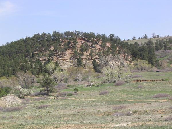
Figure 6. Light Fox Hills Formation below and Laramie Formation
above.
Where a block has been uplifted, it is called a
horst; a down-dropped block is called a graben (Figure 7). Pine
Ridge is a horst uplifted along the Pine Ridge Fault that runs
parallel to and along the north side the ridge, between the ridge
and Marshall Valley Trail. Additional faults cut Pine Ridge into
narrow horsts and grabens (South and North Gorham, High View
Fault).

Figure 7. Examples of faulting at Marshall Mesa.
N 39° 57.090'
W 105° 13.689'
Stop 4. Sandstone along Marshall Valley Trail: Where the
trail crosses the light-colored sandstone, look closely and see if
you can find the elongate curved tubes or burrows (Figure 3). These
are trace fossils that record the activity of an organism as it
moved through the sand. It is not certain what kind of animal left
these burrows. Generally burrows like these indicate a marine or
brackish water environment.

Figure 8. Trace fossils – burrows by a marine or brackish water
organism.
The sandstone, here and farther along the trail,
exhibits an interesting polygonal (many-sided) weathering pattern.
Where the rock has been cut by fractures, weathering is deeper
creating rounding of the blocks.
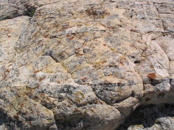
Figure 9. Polygonal weathering in sandstone.
Notice the ironstone concretions weathering out of
the sandstone (as seen at Stop 1). In places, the iron in
concretions and thicker deposits was deemed ore quality. In 1864, a
foundry and blast furnace was built by Joseph Marshall on South
Boulder Creek. It operated for two years before it was shut
down.
Continue along the trail toward the Davidson Ditch Bridge. Stop
at the fenced “sinkhole”.
N 39° 57.207'
W 105° 13.218'
Stop 5. “Sinkhole”: This “sinkhole” is probably a collapse
into an old mine tunnel or “room” beneath us. Several coal seams
were mined north of Pine Ridge. Imagine what it was like to work
underground in these mines.
Continue east to the Davidson Ditch Bridge.
N 39° 57.258'
W 105° 13.061'
Stop 6. Views from the Bridge over Davidson Ditch: Look
north (toward Marshall Road and the electrical control boxes) for
the elevated, flat surface running east-west. This is the old
railroad bed of the Colorado and Southern (C&S) Railroad. With
the development of coal mining, railroad connections to the coal
mines were essential. The first railroad into Marshall was the
Golden, Boulder, and Caribou Railway built in 1878. In 1890, the
Colorado and Southern built a railroad through Marshall that ran
from Denver to Boulder. In 1932, the Marshall Branch was abandoned
from the Crown Mine east of Marshall to Canyon Street in Boulder
and the tracks were removed.
Good exposures of the Laramie Formation are found on the south side
of Davidson Ditch. Note the alternating sandstones and shale beds
dipping (tilted) to the southeast. The dip of these beds is at
right angles to the bridge. The upper edge of the sandstone runs
east-west. Geologists describe this as the strike of the bed.
Regionally, rock units along the Front Range, like the Flatirons,
dip steeply eastward and strike north-south, parallel to the
mountains. The difference in dip and strike here is the result of
localized folding of these rocks between faults.
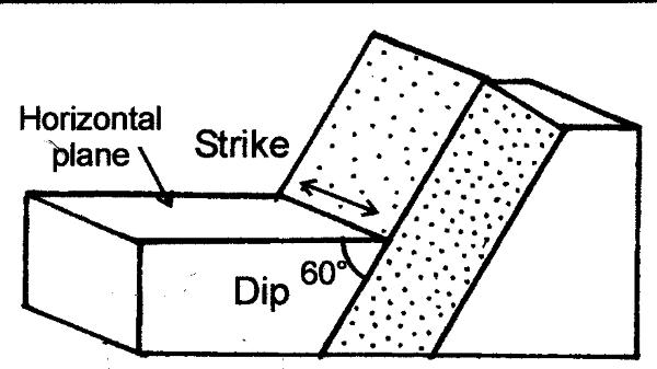
Figure 10.
After you cross the bridge, walk east (to your
left) a short distance along the trail. Notice how the sandstone
ends abruptly. It has been cut off by the Gorham Fault.
Continue up the stairs and along the trail to an excellent
exposure of the Laramie Formation sandstone (to the south (uphill
side) and across the trail.
N 39° 57.105'
W 102° 13.228'
Stop 7. Laramie Formation sandstone: At the “Geology of a
Coal Field” sign is an exposure of Laramie sandstone (Figure 8).
Rain and snow-melt run down the face of the sandstone deeply
eroding the lower surface since it is not as well-cemented as the
upper part. Unfortunately, this makes it easier for people to leave
graffiti carved into the surface.

Figure 11. Laramie Formation sandstone.
Along the trail past the sign look for a large
quartzite (metamorphosed sandstone) boulder, more than 3 feet long
and two feet across. This boulder is sitting on the Laramie
sandstone and did not form here. It has been moved from uphill to
this location. Where it came from will be discussed at Stop 12.
Continue along the Marshall Mesa Trail to the “Underground
Fires” Sign.
N 39° 57.027'
W 102° 13.413'
Stop 8. “Underground Fires” sign: Coal mine fires can start
by natural or human actions and may burn for many years. As the
fire consumes coal seams underground, areas above may subside or
collapse. This is a problem throughout the Boulder-Weld coal field
and has affected land-use planning and development in Boulder,
Lafayette and Louisville.
Continue along the Marshall Valley Trail to the intersection
with the Community Ditch Trail. Continue west on the Community
Ditch Trail.
A sliver of Fox Hills Formation (not visible under the hill slope
vegetation) is uplifted along the South Gorham Fault where the
Marshall Mesa Trail branches from the Community Ditch Trail.
The Bridge across Community Ditch - N 39° 56.884', W 105°
13.798' leads uphill to the Greenbelt Plateau Trail. This will
take you around a second trail loop (“B”) for excellent views of
Boulder Valley and the mountains to the west.
N 39° 56.891'
W 105° 13.810'
Just past the bridge across Community Ditch to the north and down
the slope are several “benches” of Laramie sandstone. This was the
location of a large coal mine. Look back from the Trailhead for a
better view.
Hiking west along Community Ditch, look at the alternating
sandstone and finer shale beds exposed across the ditch. In places,
there are excellent examples of ripple marks in the sandstone. More
ripple marks can be seen on an elongate slab of sandstone at:
N 39° 56.934'
W 102° 13.707'
Continue west along the Community Ditch Trail.
N 39° 56.769'
W 105° 14.177'
Signpost for Community Ditch Trail and Coal Seam Trail.
Walk toward Highway 93 to observe the sandstone forming the
banks of Community Ditch.
This is Fox Hills sandstone. It is fine-grained, cream-colored with
iron staining. Across the ditch and uphill are the remains of the
High View Mine.
At this point, you can take the lower part of the Coal Seam
Trail (north) to return to the Trailhead (Loop “A”) or connect with
the upper part of the Coal Seam Trail that parallels Highway 93 to
cross the ditch and then goes uphill and east to connect with the
Greenbelt Plateau Trail. A short connecting trail takes you back to
the bridge and the Community Ditch Trail (N 39° 56.884', W 105°
13.798') you already hiked.
COAL SEAM TRAIL (to return to Trailhead)
As you walk down the trail, you will get views of the remains of
the El Dorado Mine between the trail and Highway 93.
Continue north along Coal Seam Trail until you come to a hole
with a small tree growing out of it.
N 39° 56.918'
W 105° 14.016'
Stop 9. “Sinkhole” (west of the trail): Here is another
example of collapse into underground tunnels or rooms.
Continue on the Coal Seam Trail to the bridge across Davidson
Ditch.
N 39° 57.023'
W 105° 13.945'
Stop 10. Bridge across Davidson Ditch: From the west side of
the bridge, if the channel of Davidson Ditch is dry, look for
excellent examples of potholes (formed by small rocks grinding into
the sandstone as water flowed over it) and scour marks in the
polished sandstone. Stems of fossil plants can be found in the
large boulders (used to keep the bank from eroding) on the south
side of the bridge.
Walk across the bridge north to the fence. Look across Davidson
Ditch to get a clear view of the stratification in the wall of the
ditch.
A dark seam of coal is visible about two-thirds of the way down to
the bottom on the ditch on the south side. Sandstone forms the
bottom of the channel.
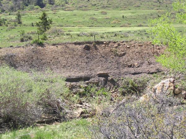
Figure 12. Coal seam exposed in wall of Davidson Ditch.
LOOP “B” UPPER COMMUNITY DITCH TRAIL TO
GREENBELT PLATEAU TRAIL
From the junction of the Community Ditch Trail and Coal Seam
Trail, walk toward Highway 93, through the gate, and close to the
edge of the Highway to access the upper part of the Coal Seam Trail
(that runs east and up the hill).
N 39° 56.705'
W 105° 14.157'
Stop 11. Seasonal closure sign: You are walking along an
exposure of (?) Fox Hills sandstone that has numerous fractures
highlighted by the more resistant iron oxide in the cracks. This
sandstone is between the Fox Hills Fault and the High View Fault,
and has been broken by movement along these faults.

Figure 13. Iron oxide filling fractures in sandstone.
Good views of the Rosser Mine location and dump
uphill and south of the trail.
As you walk uphill, look north across Marshall Road and the
intersection with Cherryvale Road. Northeast of this intersection,
note the linear (straight) features on slope. These are excellent
examples of room and pillar construction of underground mines where
the roof collapsed into the “rooms” below leaving the long
depressions. Collapse has also resulted from underground coal fires
burning here.
Walk past the sign for Community Ditch and Greenbelt Plateau
Trail to the top of the hill.
N 39° 56.701'
W 105° 13.819'
Stop 12. Rocky Flats Surface. You are now on the Rocky Flats
alluvial surface, a prominent upland surface. This gently sloping
surface extends from the mountain front to the south and east. The
flat mesas to the northwest, including NCAR Mesa, were once
continuous with this surface. Look for rounded and polished
boulders and cobbles by the trail. Most of these are metamorphic
quartzite (often blue-gray) and metaconglomerates (with pebbles of
quartz) that were carried here by floods from Coal Creek 1-2
million years ago. Over time, as Marshall Mesa was eroded, these
boulders were left scattered across the area. Some boulders are
huge, more than 3 feet across, like the one seen at Stop 7.
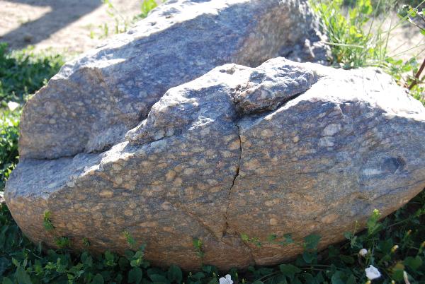
Figure 14. Metaconglomerate: blue-gray quartzite surrounding quartz
pebbles.
N 39° 56.736'
W 105° 13.857'
Sign for Community Ditch and Greenbelt Plateau Trail: Look at the
boulders scattered down the slope below the sign.
From here there are excellent views of the Front Range, Longs Peak,
the Flatirons, the “mesas” and Boulder Valley as illustrated in
Figure 1.
Follow the trail back to Community Ditch and return to the
trailhead via the (lower) Coal Seam trail.
References:
Bridge, Raymond, 2004, The Geology of Boulder County, Lone Eagle
Publications, Boulder, Colorado, 468 p.
Spencer, Frank D., 1961, Bedrock Geology of the Louisville
Quadrangle, Colorado; USGS Geologic Quadrangle Map CQ-151.
Weimer, Robert J. 1996, Guide to the Petroleum Geology and Laramide
Orogeny, Denver Basin and Front Range, Colorado; Colorado
Geological Survey, Denver, CO, 127 p.