
 Nederlands
Deze earthcache is mooi te combineren met multicache
GCC675 "De Sahara van Lommel (ja, België heeft er ook een)" van
TomPetLegend.
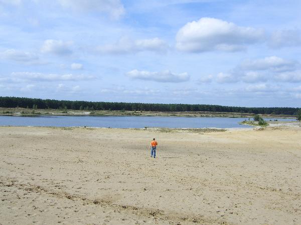
"Water en stuivend zand: Lommelse Sahara Woestijn in Belgïe.
De Lommelse Sahara heeft haar naam te danken aan de voedselarme
zandgrond waarop het ligt. Vroeger maakte dit gebied deel uit van
een groot heide- en stuifzandgebied dat een groot deel van
noord-Limburg bedekte. Het gebied is met name bekend om de
zuiverheid van het zand, dat in grote hoeveelheden werd gebruikt in
de ....industrie. Door afgravingen ten behoeve van de
....industrie, bebouwing, landbouw en industrie is het grote heide-
en stuifzandgebied versnipperd geraakt. Wat over is gebleven is nog
steeds zeer uniek.
Water wordt Land.
Door de zandwinning tot de jaren tachtig zijn drie grote, diepe,
voedselarme vijvers ontstaan. De verdroging in de Lommelse Sahara
is er de oorzaak van dat de waterbodems van de vijvers droogvallen.
Hierdoor krijgen kruiden en later struiken en bomen de kans zich in
dit deel te ontwikkelen. Op deze manier ontstaat op natuurlijke
wijze een zogenaamd pioniersbos. De vijvers zijn voor veel dieren
een geschikt foerageergebied. In combinatie met oeverbegroeiing
bieden ze veel vogels voldoende bescherming om te broeden."
 English
This earthcache can be combined with multicache
GCC675 "The Sahara of Lommel (yes, Belgium has one too)" by
TomPetLegend.
"Water and drifting sand, Lommelse Sahara, desert in Belgium.
The Lommelse Sahara got her name from the poor sandy soil on which
it is located. In the past this area was part of drifting sand and
moorland, which covered a big part of Norhern Limburg. This area is
well known for the purity of its sand. This sand was used in large
quantities for the ..... industry. By quarry of sand for the .....
industry, building houses, agriculture and other industry, the
drifting sand and moorland got fragmented. What is left over is
still very unique.
Water becomes land.
By the quarry of sand until the eighties, three large, deep, poor
ponds originated. The dehydration of the Lommelse Sahara causes the
ponds to dry out. Therefor the herbs, shrubs and trees slowly get
the change to develop. And so a new wood arises in a natural way.
These ponds are a suitable forage area for many animals. In
combination with the vegitation of the banks they give a lot of
birds enough protection to breed."
To log this EarthCache:
Foto: Maak op het coordinaat dat bovenaan deze pagina staat een
foto van jezelf met je GPS en "de Lommelse Sahara" en voeg deze bij
je log.
Opdracht: Als voorwaarde om deze earthcache te mogen loggen moet je
een e-mail sturen aan de makers van deze cache met het antwoord op
de volgende informatie: "Loop naar N51°14.988' E005°17.557'. Hier
vindt je een informatiebord over de Lommelse Sahara.
A. Voor welke industrie werd het pure zand gebruikt dat je
vindt in de Lommelse Sahara?
B. Geef 3 van de 4 Latijnse namen van (water)vogels die in dit
gebied voorkomen en die op het bord genoemd staan."
Indien de e-mail niet goedgekeurd is, wordt de log verwijderd.
LOGS MET EEN VERKEERDE FOTO OF LOGS VAN MENSEN DIE EEN FOUT
ANTWOORD OP DE VRAAG GEMAILD HEBBEN WORDEN DIRECT
VERWIJDERD!!!
Picture: Go to the coordinates on top of this page and take a photo
of yourself with your GPS and "de Lommelse Sahara". Add this
picture to the log.
Assignment: For logging this earthcache you are required to send an
e-mail to the makers of this cache which contains the following:
"Goto N51°14.988' E005°17.557'. Here you'll find an information
sign about the Lommelse Sahara.
A. For which product was the pure sand, which can be found in
the Lommelse Sahara, used?
B. Give 3 of the 4 Latin names of (water)birds that live in this
area and are named on the sign."
If an e-mail is found to be incorrect the log will be deleted.
LOGS WITH A WRONG PICTURE OR LOGS FROM PEOPLE THAT E-MAILED
INCORRECT ANSWERS TO THE QUESTION ARE REMOVED
IMMEDIATELY!!!