Getting There:
The nearest city to this cave as the crow flies is Kalgoorlie 440km away (622km fastest time on GPS). As the crow flies this cave is 1223km from Adelaide (1559km fastest time on GPS). Once you arrive in the area the 10km track from Eyre Highway to the cave is uneven and not maintained. 2WD is ok when it’s dry. It is not recommended for caravans. Your choice to complete this cache depends on your level of driving skill and experience.
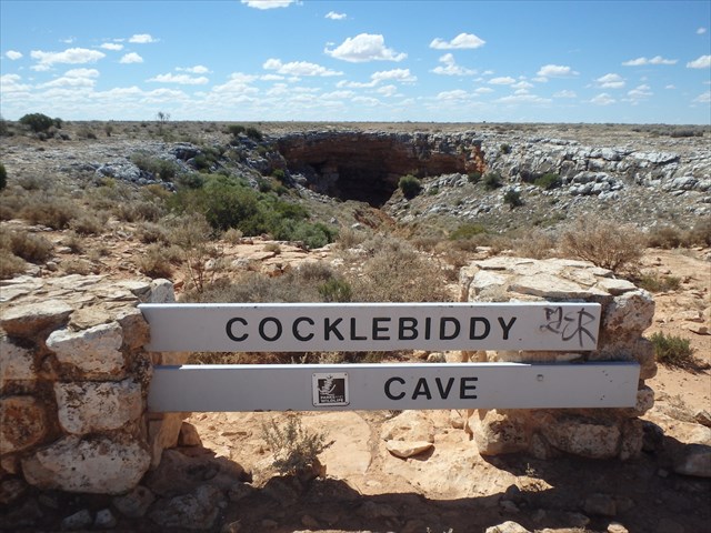
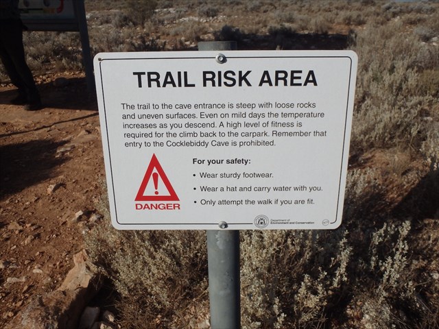
If you visit the cave in hot weather be sure to come prepared as this is a remote area with very few visitors. The temperature regularly exceeds 40ºC. Entry to the cave is restricted because descent and ascent is made difficult by the steep cave entrance and the rough loose rocks that have to be climbed over to descend the 200m in and 100m down to water level. The water is crystal clear and cold, much too cold to swim in without the aid of a dive suit. Light is limited to the little that filters through the cave entrance.
The entrance is considerably narrower than the huge chamber inside. There is a walk trail to the entrance but no entry beyond that is allowed unless with the required permit. At the head of the walk trail is a strong risk warning. A ladder or other climbing gear is needed to enter and exit the cave if you have a permit.
The Geology:
The Nullarbor Plain occupies most of the Eucla Basin, a region that underwent repeated flooding and retreating by an ancient sea. The Ooldea and Barton Ranges, on the north-eastern margin of the Nullarbor, are ancient coastal dunes that mark the extent of an Eocene sea. Sediment deposited by the ancient seas during different eras can be seen as distinct layers. Fossils of marine snails, sand dollars and other sea creatures that point to the Nullarbor’s marine origins can be seen at the entrance to Cocklebiddy Cave.
Cocklebiddy Cave is one of many thousands of caves that dot the Nullarbor karst.... the largest arid area of exposed limestone in the world. Some of the features include rocky ridges, broad pavements, caves, dolines, blowholes and circular clay-filled depressions called ‘dongas’. The entrance to Cocklebiddy Cave is an example of a collapsed doline.
Most of the caves on the Nullarbor were formed by the action of groundwater which dissolves the limestone in all directions to form telltale rounded walls. Some passages collapse to become large underground chambers with high domed ceilings. Others penetrate the groundwater and lead from cool, clear lakes submerged well below the surface of the earth.
Cocklebiddy Cave is arguably the Nullarbor’s most famous cave and has been the object of many expeditions. It is an average of 100m below the surface and more than 90% of it is under water. In 1983 it became the world’s longest cave dive when a distance of 6.24km from the cave entrance was reached.
There is an Earthcache at Caiguna Blowhole on the Nullarbor.... GC2NNJ6.
Remember to take only photos and leave no trace of your visit. We hope you enjoy your visit to this geologically interesting area 'on the long drive' in Western Australia.
In order to get your smiley you may log this Earthcache straight away but then please email your answers to the questions to the CO. We will contact you ONLY if your answers need extra work. Logs with no answers sent will be deleted. Please do not post your answers in your log.
Q1. By researching, explain what a doline is.
Q2. Look directly at the face of the cliff above the cave entrance. What feature can you see left of centre? donga, column, ledge, tunnel, doline or pillar
Q3. Look carefully at the rocks immediately above the cave entrance. Based on info from the noticeboard at the head of the trail what age is this layer of rock?
Q4. By interpreting the Life on Earth timeline which geological age was this limestone formed in?