Muskoka Rocks!!! Well of course it does. If it didn't why would millions of tourists flock here each year?
For those who live in Muskoka there's a different type of Muskoka Rock that we find annoying. The type found in the soil. Everywhere time you mow the lawn, build a house, or dig a hole you always run into Muskoka rocks. These rocks are so famous (and annoying) that some souvenir shops have even started selling them.
So why does Muskoka have so many rocks when an hour down the road in Simcoe county there are hardly any? Excellent question! The answer is simple -- Muskoka is situated on the lower end of The Canadian Shield, also known as the Precambrian Shield or Laurentian Plateau.
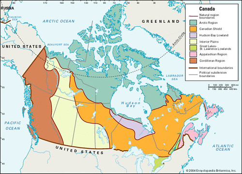
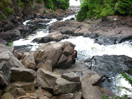
So what is the Canadian Shield? The Canadian Shield is the oldest part of the North American crustal plate. It’s so big that it covers an area of 4.4 million square kilometres, which is about half of Canada, most of Greenland, and the northern U.S.A. It’s plateau ranges from 305 to 610 meters above sea level. The Canadian Shield was the first part of the North American continent to be permanently raised above sea level, but this process was not uneventful. During the Precambrian geological era (500 million years ago) through severe reoccurring glaciation (invasion and withdrawal of ice sheets more severe than Muskoka gets each winter), rising and falling, erosion and folding forged the Canadian Shield and scraped out tens of thousands of lake basins. The signs are evident throughout Muskoka by the vast number of clean clear lakes great for fishing.
The Canadian Shield is composed of granite and the world’s greatest area of exposed Precambrian rock (both igneous and metamorphic). Severe glaciation during formation scraped the rocks clean leaving only a thin layer of soil lying on the Precambrian bedrock. While this bedrock makes firm foundations for building houses the remaining soil is not suitable for farming. However, the lowlands contain numerous swamps, marshes, and bogs with very dense soil with poor hydrographical drainage. The Precambrian rock covering the shield is known as one of the world’s richest areas for mineral are deposits of gold, silver, copper, nickel, uranium, platinum and molybdenum. The largest and most famous mine on the shield is in Sudbury, Ontario, which is famous for nickel and copper mining, the big nickel, and the INOC Superstacks.
Halfway between Gravenhurst and Orillia is a small town called Severn Bridge. Whilst the town of Severn Bridge is situated on the Canadian Shield the Severn River forms a clear boundary between the Canadian Shield (north shore) and the Great Lakes-St Lawrence Lowlands (south shore). This river also marks the boundary between the District Municipality of Muskoka (north shore) and Simcoe County (south shore).
This Earthcache can be done on your journey between Gravenhurst and Orillia. You will need to be observant around the landscape formations and changes.
To log this Earthcache you need to:
- Take two photos of yourself with or without GPS showing the different geological features between the Canadian Shield and the Great Lakes-St Lawrence Lowlands. These photos can be taken at the co-ordinates or somewhere nearby. Whilst optional these photos will help you answer question 3 and enhance your log.
- From the parking co-ordinates you can see an outcrop of Precambrian rock. Estimate the height of this outcrop.
- This outcrop has at least two distinct layers of rock. Describe them. What types of rocks do you think these are and why?
- Describe three visible difference the Canadian Shield and the Great Lakes-St Lawrence Lowlands.
- Heading north on highway 11 you might pass Barrie (221 m), Orillia (220 m), Severn Bridge (231 m), Gravenhurst (268 m) and Huntsville (289 m), Based on the altitudes (elevations) of these towns what does it tell you about the Great Lakes-St Lawrence Lowlands and the Canadian Shield. Keep in mind that the Severn river is border between the two.
Please e-mail us the answers to tasks 2 to 5. Please do not post any of your answers in your log as it will ruin the educational experience for other geocachers. Any logs with such information will be deleted. Once you have e-mailed us the answers feel free to log your find. If there are any problems we will be in contact.
Hope you enjoyed learning about our famous Muskoka rocks. As you enjoy your vacation or have a look and the Muskoka scenery just remember the Canadian Shield. It’s big and beautiful, but don’t take it for granite.