EARTHCACHE REQUIREMENTS:
Please send answers prior to posting your find to the
earthcache. Do not post the answers in your log. If you can
not post your picture at the time of your log, then log it as a
note until you can upload the picture. Any log that does not meet
the requirements will be deleted without notice.
1.) Picture requirement: My intentions are to have you post
your picture with the dam in the background. If you refuse to post
your face in the picture, then each log must have a unique picture
for each log. Tilting the picture with a photo program will not be
acceptable for unique. Group photos must reference who's picture
you are in otherwise. A unique picture must be included with every
log if you are not in the picture.
Remember that I will delete your log if you post a find saying
you will upload the picture or send answers at a later time. Please
use the "write a note" feature.
2.) Send answer to the following questions through my
profile:
a. Name three reasons why was the Chickamauga dam built?
b. How high is the dam?
c. What is the length across?
e. Two reservoirs were created by the building of the dam, what are
they?
f. How many towns were established along the Tennessee and
Chickamauga Creek as a result of the building of the dam?
g. You will find a picture of the building of the dam at sight and
the second picture down on this earthcache page. Please describe
how the dam has changed the surrounding landscape.
h. What is the major priority in the design of TVA reservoir system
for Chattanooga?
i. What was the deciding geological factor for the site location
choice for the building of the dam?


Chickamauga Dam is the fourth of the TVA's main river projects,
and is located 20 miles northeast of Chattanooga. Construction
began in January 13, 1936 and the dam went into operation four
years later. The filling of Chickamauga Reservoir began January 15,
1940. The water shed for the reservoir is 20,790 square miles.
Completion of the project took over 500,000 cubic yards of
concrete and almost 3,000,000 cubic yards of earth and rock, with a
cost of almost $40,000,000. A total of 13.9 million man hours were
required to complete the Chickamauga Reservoir and Dam project.
Chickamauga Reservoir, with 810 miles of shoreline, has 35,400
square acres of surface area. It was constructed for the purpose of
electric power, flood control, navigation, recreation, an adequate
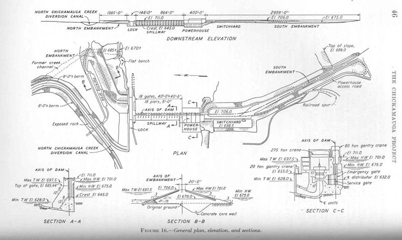
supply of water and other related benefits. The lock at Chickamauga
Dam is 360 feet by 60 feet, and raises boats and barges up to 50
feet to Nickajack Lake.
Chickamauga got its name from a tribe of indians that broke away
from the main body of the Cherokee Nation. The Chickamauga tribe
lived in villages nearly a mile long all along the Chickamauga
Creek which flows into the main river body just below the dam.
TVA’s reservoir system was primarily designed to protect
15 damage centers—locations that were statistically likely to
suffer flood damage.
Of these damage centers, Chattanooga is at greatest risk. The
city sits in a low plain between the eastern and western parts of
the Tennessee Valley just above the point where the Tennessee River
passes through the Cumberland Mountains.
Before TVA started its flood operations, major storms occurring
in the 21,400-square-mile drainage area above Chattanooga would
cause the Tennessee River to rise rapidly. When it reached
Chattanooga, the swollen river would attempt to carry more water
through the narrow mountain passes below the city than the river
channel would allow. The excess water that could not flow
immediately through the mountains would naturally back up to the
city, flooding it on the average of once a year. For this reason,
reducing the flood risk at Chattanooga was a major priority in the
design of the TVA reservoir system and remains a major operating
priority today.
The TVA dam and reservoir system prevents millions in flood
damages in an average year, but it cannot prevent all flooding.
The largest flood in Chattanooga’s history occurred in
March 1867, before the TVA system was created. The flood crested at
58 feet and completely inundated the city. Since the completion of
the reservoir system, the highest Chattanooga flood stage was
nearly 37 feet, which occurred in 1973. Without regulation, the
flood would have crested at 52.4 feet.
The original flood protection plan for Chattanooga called for
the construction of levees to supplement the protection provided by
upstream reservoirs. But because the city did not meet the
requirements of the Flood Control Act of 1936, the levee system was
never constructed.
Background and construction
The U.S. Army Corps of Engineers surveyed the Chickamauga Island
site in the 1920s as a possible site for a dam to protect
Chattanooga, which had suffered serious flood damage in 1867, 1875,
1886, and 1917, and to enhance navigation along the river. When the
Tennessee Valley Authority was formed in the mid-1930s, it assumed
control of navigation and flood control operations in the Tennessee
Valley. After extensive surveying, TVA chose the tip of Chickamauga
Island over several other sites surveyed by the Army Corps in the
vicinity. The Chickamauga project was authorized December 31, 1935,
and dam construction began January 13, 1936.
The construction of Chickamauga Dam and its reservoir required
the purchase of 61,350 acres (24,830 ha) of land, 6,030 acres
(2,440 ha) of which were wooded and had to be cleared. 903
families, 24 cemeteries, and 81 miles (130 km) of roads had to be
relocated. An embankment was built to protect parts of Dayton,
Tennessee from the reservoir's backwaters, and several roads and
buildings in the town of Soddy were relocated or modified. A total
of 39 bridges affected by the reservoir were either raised or
moved.
The navigation lock at Chickamauga Dam was designed by the Army
Corps of Engineers, and was based on the lock design at
Guntersville Dam. The lock was initially 60 feet (18 m) x 360 feet
(110 m), although the dam was designed in a way that allowed a
larger 110 feet (34 m) x 600 feet (180 m) lock to be installed if
increases in river traffic ever required it.
Chickamauga Dam was completed and its gates closed on January
15, 1940, constructed at a cost of $42,065,000. The lock was placed
into operation on February 26, 1940, and the first generator went
online May 4, 1940.

Shaded map showing the extent of the March 1867 flood in
downtown Chattanooga, Tennessee, USA. Dam construction by the
Tennessee Valley Authority in the upper Tennessee Valley in the
1930s and 1940s largely ended Chattanooga's persistent flood
problems.