This is the last in a series of eight earthcaches being developed at major points of interest in Newberry National Volcanic Monument in cooperation with the staff of the Deschutes National Forest. The Lava Butte summit is usually accessible by car from mid-May to late-October. The road can be hiked during the off season. This earthcache is located along the Lava Butte Trail at the summit.
To log this earthcache please post your favorite photo from this site and e-mail me the answers to the following questions (according to information on the signs along the Crater Rim Trail):
Note: The original signs this earthcache was based on were replaced with new ones in the fall of 2013. The earth cache has now been updated with new questions (May 2014).
- What state is Newberry Volcano about the same size as?
- How many miles of the Deschutes River channel were filled by flows from Lava Butte?
- There are more than how many volcanoes in the Cascade Range?
- At N 43° 55.045' W 121° 21.470' there is a 10” diameter pine, about 4 feet to the north of the tree is a large vesicular spatter bomb that is cut in half, what is the length and height of the exposed face of the bomb?
While doing this earthcache you may also be able to collect the necessary information to claim multiple waymarks in the area.
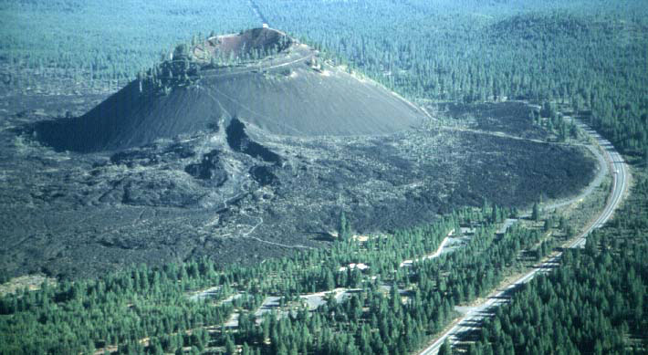 The Lava Butte area includes about a 1 mile segment of the NW Rift Zone of Newberry Volcano. About 7,000 years ago activity along the rift began with fire fountaining along the segment and small flows from the fountains. After a few days activity localized at the location of Lava Butte and a cinder cone began to form. As degassed magma rose in the cone it broke through the thin south side of the cone and fed a series lava flows that spread to the west and north blocking the Deschutes River.
From the summit of Lava Butte there is a 360 degree view of Central Oregon. Cascade peaks are visible from Mt. Adams in Washington to Mt. Scott in Crater Lake N.P.
View from Summit View Point
| NORTH |
|
|
|
|
| |
N 5 E
|
-
|
11 mi
|
-
|
Awbrey Butte -- Deeply eroded shield volcano, more than 4,000,000 years old. |
| |
N 19 E
|
-
|
10 mil
|
-
|
Pilot Butte -- 188,000 year old cinder cone |
| |
N 56 E
|
-
|
8 mi
|
-
|
Horse Butte -- Cinder cone |
| EAST |
|
|
|
|
| |
S 34 E
|
-
|
7 mi
|
-
|
Mokst Butte -- Cinder cone on NW Rift zone |
| |
S 19 E
|
-
|
17 mi
|
-
|
Paulina Peak -- Rhyolite dome which formed about 83,000 years ago, shortly before the large eruption which resulted in the formation of Newberry Crater |
| |
S 3 E
|
-
|
6 mi
|
-
|
Sugar Pine Butte -- Cinder cone with microwave tower |
| SOUTH |
|
|
|
|
| |
S 2 W
|
-
|
13 mi
|
-
|
McKay Butte -- 600,000 year old rhyolite dome |
| |
S 10W
|
-
|
19 mi
|
-
|
Finley Butte -- Cinder cone |
| |
S 22 W
|
-
|
4 mi
|
-
|
Abbot Cinder Pit -- Cinder pit on cinder cone |
| |
S 22 W
|
-
|
46 mi
|
-
|
Walker Mountain -- Fault scarp |
| |
S 25 W
|
-
|
76 mi
|
-
|
Mt. Scott -- Composite volcano east of Crater Lake |
| |
S 26 W
|
-
|
76 mi
|
-
|
Cloud Cap -- A high point on east rim of Crater Lake |
| |
S 30 W
|
-
|
76 mi
|
-
|
Llao Rock -- Dome on northwest rim of Crater Lake |
| |
S 54 W
|
-
|
48 mi
|
-
|
Diamond Peak -- Deeply glaciated composite volcano. |
| |
S 56 W
|
-
|
36 mi
|
-
|
Maiden Peak -- Glaciated composite volcano with plug. |
| |
S 60 W
|
-
|
5 mi
|
-
|
Sunriver Meadows -- Old lake bed resulting from the damming of the Deschutes River by the Lava Butte lava flow 7000 years ago. |
| |
S 86 W
|
-
|
17 mi
|
-
|
Sheridan Mountain -- Cinder cone capped shield volcano |
| WEST |
|
|
|
|
| |
N 83 W
|
-
|
16 mi
|
-
|
Kwolh Butte -- Cinder cone on south flank of Mt. Bachelor |
| |
N 76 W
|
-
|
17 mi
|
-
|
Mt. Bachelor -- Summit cone on shield volcano |
| |
N 76 W
|
-
|
4 mi |
-
|
Benham Buttes -- 1,800,000 year old domes. The 7000 year old Lava Butte flow abuts the east end of the domes and dammed the Deschutes River resulting in a lake. When the lake overflowed and drained, Benham Falls was created. |
| |
N 59 W
|
-
|
24 mi
|
-
|
South Sister -- Composite volcano |
| |
N 58 W
|
-
|
21 mi
|
-
|
Broken Top -- Deeply glaciated composite volcano |
| |
N 54 W
|
-
|
27 mi
|
-
|
Middle Sister -- Glaciated composite volcano |
| |
N 51 W
|
-
|
27 mi
|
-
|
North Sister -- Glaciated shield volcano |
| |
N 33 W
|
-
|
46 mi
|
-
|
Three Fingered Jack -- Glaciated shield volcano |
| |
N 24 W
|
-
|
57 mi
|
-
|
Mt. Jefferson -- Glaciated composite volcano |
| |
N 24 W
|
-
|
36 mi
|
-
|
Black Butte -- 1,400,000 years old unglaciated composite volcano |
| |
N 10 W
|
-
|
102 mi
|
-
|
Mt. Hood -- Glaciated composite volcano |
| |
N 4 W
|
-
|
152 mi
|
-
|
Mt. Adams (Washington) -- Glaciated composite volcano |
| NORTH |
|
|
|
|