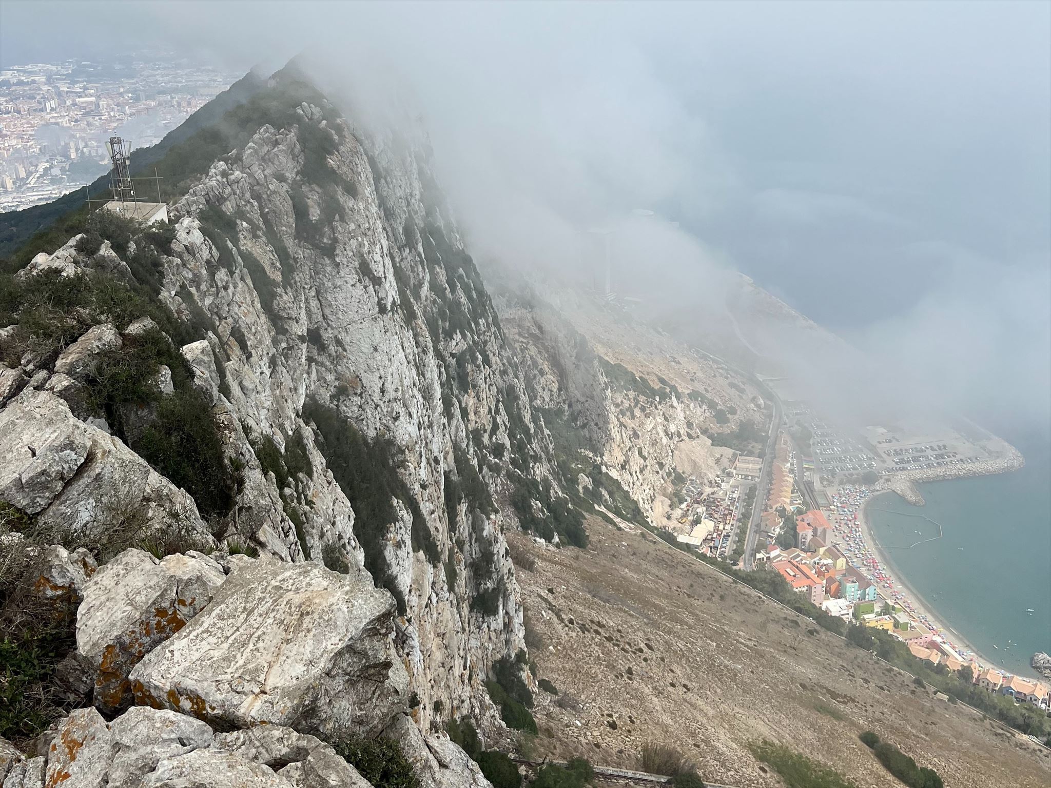
The Rock of Gibraltar is a prominent limestone monolith located at the southern tip of the Iberian Peninsula, overlooking the entrance to the Mediterranean Sea. Rising to an impressive height of 426 meters, it has long been a symbol of strength and endurance. The Rock is a British Overseas Territory and is known for its strategic significance, having played a crucial role in naval history.
One of the most iconic features of the Rock of Gibraltar is its population of Barbary macaques. These macaques are the only wild monkey population in Europe and have become a symbol of the area. Visitors to the Rock often encounter these playful and mischievous primates, known for their cheeky antics and entertaining behavior.
The Rock of Gibraltar is not only famous for its strategic significance but also for its intriguing geological formation. Perhaps one of the most striking features that immediately catches the eye is the stark contrast between one side, which presents a towering vertical cliff, and the other, with a more "gradual" slope leading up to its summit. The formation of the Rock of Gibraltar is a result of complex geological processes that unfolded over millions of years. It originated at the convergence of the African and Eurasian tectonic plates, where intense compressional forces gave rise to faulting. Specifically, the eastern side of the rock experienced substantial uplift and tilting along the fault plane. This uplifted mass consists primarily of limestone and other sedimentary rocks, forming the iconic escarpment of Gibraltar. Erosion and weathering have further shaped this geological landmark, showcasing the dynamic nature of Earth's crustal evolution.
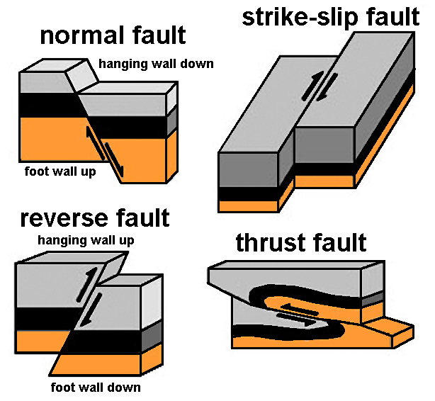
There are several different types of geologic faults, each displaying its own unique geologic characteristics. A key concept is the hanging wall, which refers to the block of rock above a fault plane, and the footwall, which is the block below it. In a normal fault, the hanging wall moves downward relative to the footwall, typically exhibiting a dip angle ranging between 45 and 90 degrees. In mountainous regions, many normal faults result from gravitational forces along the mountain edges and may coincide with the uplift of the headwall of landslides. On the other hand, in a reverse fault, the hanging wall moves upward relative to the footwall. A thrust fault displays a dip angle of 45 degrees or less, causing the hanging wall to seemingly move upward in relation to the footwall. Horizontal compression or rotational forces are responsible for this type of displacement. Finally, a strike-slip fault is primarily vertical, with both sides sliding horizontally past each other. When the block opposite an observer shifts to the right, it's termed "right-lateral," and when it moves to the left, it's referred to as "left-lateral." The San Andreas Fault in California is a renowned example of a right-lateral strike-slip fault.
Another topic worth mentioning is strike and dip. In geology, strike and dip are fundamental concepts used to describe the orientation and inclination of geological features. Strike refers to the compass direction of a line formed by the intersection of a geological surface, such as a rock layer or fault plane, with a horizontal plane. It essentially tells us the direction in which the feature extends on the Earth's surface. For instance, if a rock layer trends east-west, its strike is east-west. Dip, on the other hand, quantifies the angle at which the geological feature is inclined relative to the horizontal plane. It's measured perpendicular to the strike direction. For example, if a rock layer has a dip of 30 degrees to the south, it means the layer inclines at a 30-degree angle below the horizontal surface in a southward direction. Together, strike and dip provide crucial information for geologists to accurately describe and understand the orientation and inclination of rock layers, fault planes, and other geological structures, which are vital for unraveling the geological history and predicting subsurface conditions.
Logging Requirements:
- Describe the Rock of Gibraltar. Looking around, do you see any evidence of folded rock layers? If so, what forces do you think might have led to their deformation?
- At the posted coordinates, estimate the strike and the dip of the Rock of Gibraltar (hint: use the compass and level on your phone).
- As you explore the Rock of Gibraltar, keep your eyes open for any exposed rock outcrops. Estimate the dip angle, and take note of the approximate location and elevation. Is it similar to what you measured at the top? If not, why do you think they are different?
- Based on the description and your observations, what type of fault would you consider the Rock of Gibraltar as being a result of?
- Upload a photo taken at the overlook, or with the famous monkeys!