Welcome to
Orania Oewers EarthCache

Your tasks – the C.S.I. work!
In order to substantiate your visit and be able to claim this EarthCache a number of questions need to be answered and submitted to the cache developer, via e-mail, to “cincolcc [at] gmail.com”
1 – In your own words explain what the river looks like at the time of your visit. Comment on the banks and how have they been formed - what do you think they are composed of? [If the river is in flood you will not be able to see the banks then you can estimate how far the water’s edge is from where you are standing.]
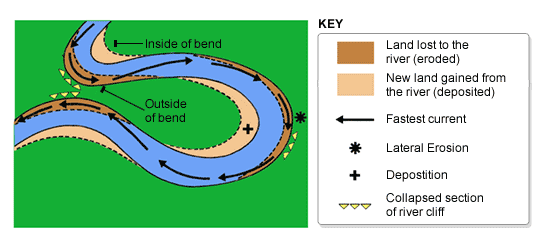
2 – Is there any evidence of the river undercutting the banks? Think about what you might have seen en route to GZ as well. What effect will this undercutting have on the formation of the sandbanks themselves?
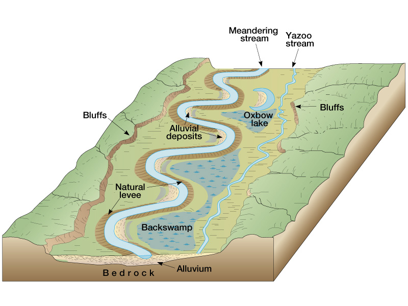
3 – Would you classify this as an old, mature or a young river system? Why do you say so?
4 – When entering the resort there is a very prominent orange coloured sign post indicating the flood level of the river. Estimate how far it is from the river AND how high would you guess the water was at the time? [Your estimates will be good enough for me]
5 – Describe any other interesting things you saw or experiences you had on your journey to GZ - whether you traveled from Hopetown or Vanderkolff.
6 – What building is to your RIGHT at GZ?
NOTE: You may log your visit prior to approval, but e-mail submissions that do not meet the above criteria will be deleted.
The Orange rises in the Drakensberg mountains along the border between South Africa and Lesotho, about 193 km (120 mi) west of the Indian Ocean and at an altitude of over 3,000 m. The extremity of the Orange River inside Lesotho is known as the Senqu. Parts of the Senqu River freeze in winter because of the high altitude there. This creates droughts downstream, which mainly affect goat and cattle production.
The Orange River then runs westward through South Africa, forming the south-western boundary of the Free State province. In this section, the river flows first into the Gariep Dam (the largest in the country), and later into the Vanderkloof Dam. From the border of Lesotho to below the Vanderkloof Dam, the river bed is deeply incised. Further downstream, the land is flatter, and the river is used extensively for irrigation.
At the western point of the Free State, southwest of Kimberley, the Orange meets with its main tributary, the Vaal River, which itself forms much of the northern border of the province. From here, the river flows further westward through the arid wilderness of the southern Kalahari region and Namaqualand in the Northern Cape Province to meet with Namibia at 20°E longitude. From here, it flows westward for 550 km, forming the international border between the province and Namibia's ǁKaras Region. On the border, the river passes the town of Vioolsdrif, the main border post between South Africa and Namibia.
This image shows only the last 100 km or so of the Orange River, in which the gravel deposits in the river bed and along the banks are rich with diamonds, and several diamond mines operate along this stretch.
In the last 800 km (500 mi) of its course, the Orange receives many intermittent streams, and several large wadis lead into it. In this section, the Namib Desert terminates on the north bank of the river, so under normal circumstances, the volume of water added by these tributaries is negligible. Here, the bed of the river is once again deeply incised. The Augrabies Falls are located on this section of the Orange, where the river descends 122 m (400 ft) in a course of 26 km (16 mi).
The Orange empties into the Atlantic Ocean between the small towns of Oranjemund (meaning "Orange mouth") in Namibia and Alexander Bay in South Africa, about equidistant between Walvis Bay and Cape Town. Some 33 km (21 mi) from its mouth, it is completely obstructed by rapids and sand bars and is generally not navigable for long stretches.
The river has a total length of 2,200 km (1,400 mi).
At GZ you will find yourself looking at the Orange River that flows past the restaurant at Aan de Oewers Chalets.
How are Rivers Formed?
Are you aware of the fact that rivers are one of the sources of fresh water? The points of origin of most rivers is in the mountains. The Orange River has its origins in the Drakensberg Mountains.
A natural stream of fresh water flowing downhill from its source in the mountains to meet an ocean or a lake is known as a river. River water is confined to a channel or a stream bed.
Rivers are formed when group of springs and streams known as headwaters (which have their origin in the mountains), flow down to form a large stream or springs. The stream bed of a river lies between the banks of a river. The large streams are called a river while the smaller ones are called creeks, brooks, rivulets, or tributaries. The rivers form a major component of the water cycle. The water in a river is accumulated from precipitation of ground water and also through the release of stored water in natural reservoirs such as glaciers.

Formation of Rivers
Every river in this universe has a point of origin and gravity plays a significant role in the direction of the flow of a river. In areas where the climate is humid, the point of origin of the rivers is from springs. Other points of origination of rivers are marshes, lakes, and melting glaciers. Thus, the two main sources of water that replenish rivers is either the melting snow or the rainwater. This process is known as the precipitation.
Another major source of river water is the rain. When it rains heavily in the hills, the water trickles down the steep slopes and flows onto a riverbed. Initially, the water from the hills flows in an evenly distributed fashion and is called surface run-off. When this water flow travels a certain distance, it begins to flow in parallel rills and also gathers momentum. Soon these parallel rills unite to form a stream. As the rills converge with the stream, a brook is formed. This brook flows through a valley. The volume of the water in a brook becomes constant when it gains sufficient volume of groundwater. The brook becomes a river when the water level in the brook increases.
Types of Rivers
Rivers are classified on the basis of the sediments they carry. The sediment carried is controlled by factors such as climate, geology, and the stream gradient. Here are a few classifications of the different types and forms of rivers.
Youthful River
A youthful river has a steep gradient and very few tributaries. A youthful river is bound to flow quickly and swiftly.
Mature River
A mature river is less steep and flows slowly compared to youthful rivers. There are many tributaries that feed a mature river. The river will meander and is generally slow moving and sediment can deposit on its banks.
Old River
An old river has a low gradient and is dependent on flood plains. Old rivers are generally very wide, deep, slow flowing with a gradual gradient.
Rivers have been one of the sources of food, water, and transport since pre-historic times. Rivers aid the cultivation of crops by supplying water. Historians claim navigation of rivers date back to the Indus Valley Civilization. Rivers of the world are the major source of fresh water and they sustain their own food chain.
In the case of the southern area of the Kruger Park the Sabie River is its “life blood”! Not only does it supply much needed water for the vegetation of the area but also water for the animals. Closer to the ocean it is an important source for agriculture in neigbouring Mozambique.