Oakwoods Metropark, and its 1,756-acres. lie in the footprint of ancient glacial Lake Whittlesey which formed about 12,500 years ago. As the Erie Lobe of the Wisconsin Glacier retreated at the end of the last ice age, it left melt-water in a previously-existing valley area. The lake stood about 740 feet above sea level and existed for about five-hundred years.

As the lake's beaches stabilized, sand was deposited in the surf zone and, farther away from the waterline creating glacial sandbars and ridges. Beach ridges are landforms that form in the coastal zone when the lake level stabilizes for a brief period (perhaps a few decades or more). They are typically made up of sandy soil and sediment and often form a step-like terrace. The area you are standing at was once a great ridge along Lake Whittlesey.
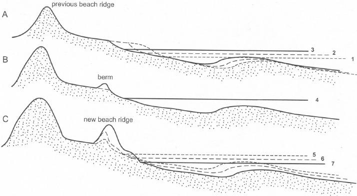
(A) As the glacier melted and the lake level rose, (1 to 2 to 3) the shoreline is eroded landward.
(B) As the rising lake level slows and eventually stops (4), a ‘berm’ forms at the top of the swash zone or the part of the beach is where waves break and rush up the beach face. Sediment built around the berm and grasses colonized the berm crest. These grasses traped wind-blown sediments, causing the ridge to grow in height
(C) As the lake level fell (5 to 6 to 7), the shoreline grew or progrades lakeward, and a new ridge is formed.

Examples of these glacial beach ridges can be found along the Long Bark Trail at Oakwoods. While foot traffic and maintenance have smoothed the ridges along the trail, the peaks and valleys are more pronounced by looking at the surrounding area off-trail.
To log this cache:
Please send me the answers to #1 and #2 through my profile page.
- In your message, describe the ground that makes up the ridge. Remember, that human intervention (e.g. trail maintenance) may have altered the area where you stand, so you may want to look at the areas immediately off the trail Is it rocky, grassy, gravel, etc.?
- Looking at the areas around the posted coordinates, you will notice the rises and falls of the ridges - this is particularly noticeable if you look off-trail Based upon your observations of the area and the information presented above, in which general direction to you think the ancient lake laid?
This cache is located along the Long Bark Trail within Oakwoods Metropark. A Metroparks vehicle permit is required for entry to the parks: $10 daily pass, $40 annual pass, $29 annual seniors pass. All park rules and regulations apply. Please park in parking lots only.
For general information please call 810-227-2752 800-47-PARKS, or visit www.metroparks.com. Dogs on a leash are NOT allowed in this section of the park. The hours for OAKWOODS METROPARK are 6 am to 10 pm. Daily.
Special thanks to Southern District Interpretive Supervisor Kevin Arnold and the staff of Oakwoods Nature Center for allowing this EarthCache.