The earthcache is located within Two Lights State Park. This is an earthcache so there isn’t a container to find but instead you discover something about how the geology of the area has changed over the last 420 million years.
To log this cache as a found, you will visit the park at the posted coordinates, read the geology lesson below, view the geology of the cliffs to apply what you just learned, and then send me answers to a few questions located below. Do not leave the path and climb on the rocks as it is too dangerous. You can view the geology of the area and find the answers to the questions while standing at the posted coordinates.
Two Lights State Park is a public recreation area occupying 41 acres of headland on Cape Elizabeth, Maine, that offers sweeping views of Casco Bay and the Atlantic Ocean. The park is open all year from 9:00 a.m. to sunset daily unless otherwise posted at the gate. Note, there is a fee charged year round to enter the park.
Use caution when walking along the paths by the ocean due to the unpredictability of the surf and the chance for a rogue wave. Keep a close eye on children who are in your care.

Kittery Formation Earthcache
All the rocks at Two Lights State Park belong to a single geologic formation. Geologists in the early 1900's referred to it as the Cape Elizabeth Formation, but geologists now think that the rocks are part of the Kittery Formation, which is found along the southern Maine coast and into New Hampshire. The Kittery Formation is a thick sequence of layered sedimentary rocks that have been metamorphosed, or changed by heat and pressure.

Silurian Period: 420 million years ago
This process started about 420 million years ago during the Silurian Period when the layers, or beds, were originally sediments such as sand, silt, and mud, deposited in an ancient ocean basin. This basin lay between the edge of North America to the west, which at the time ran approximately from Flagstaff Lake to northern Moosehead Lake, and an ancient microcontinent to the east, called Avalon. The layers of sediment that accumulated in that Silurian ocean are preserved in the rocks at Two Lights as light gray, massive quartzite and dark gray phyllite layers.

Devonian Period: 380 – 405 million years ago
During the Devonian Period, the Avalon microcontinent moved slowly toward the North American continent by plate tectonic motion and the Silurian sediments of the intervening ocean became severely compressed and deformed. The earth's crust in this collision zone became thicker as it was squeezed, producing a great mountain range. The rocks we see at Two Lights were subjected to heat and pressure during this mountain building process. The layers were contorted into folds.

Within the folds, microscopic mineral grains became aligned to produce a rock cleavage, a wood-like "grain" along which the rock splits into sheets and splinters. Many visitors to Two Lights State Park mistakenly think that the wood grain appearance of the rocks is due to their being made of petrified wood. There is no petrified wood here. Minerals in the rock recrystallized under the prolonged heating to grow slowly into metamorphic minerals such as mica and chlorite, turning mudstones into phyllite and turning sandstones into quartzite.
Late Carboniferous Period: 290 million years ago
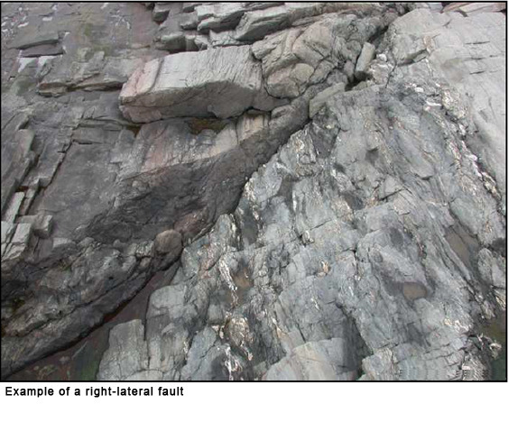
During this time, continental-scale motions in Maine were no longer compressional, but were mainly sideways, with eastern Maine moving toward the southwest with respect to central Maine. The rocks at Two Lights are thought to have cooled since the Devonian, because the geologic features of this age are typical of brittle deformation in which the rocks broke rather than folded. When rocks moved to the right relative to the rocks on the left, geologists call this type of fault a right-lateral fault. Along these faults, the rock was broken and straight, vertical fractures opened in the rock and were filled with quartz to produce long, white veins. The white quartz veins were produced during metamorphism as hot fluids containing dissolved silica circulated through small open spaces in the rock, leaving small quartz deposits.
The modern coastline is still being shaped by the ocean which has washed away all of the unconsolidated glacial deposits that used to cover the bedrock along the shore so that the rock ledges are exposed. Occasionally, even large blocks of rock are dislodged. Storm waves loosen and move blocks from the bedrock preferentially along structurally weaker zones such as dikes, faults, and fractures.
Questions
To get credit for this earthcache, you will need to send to me the answers to the following questions by email or Message Center. You don't have to wait for a response from me after you send the answers. You may log this as a find online as soon as you send in your answers.
- Name of earthcache: Kittery Formation
- Rock formation #1: Looking straight down the ledge, describe the rock formation. Which time period do you think this rock formation was formed and why?
- Rock formation #2: Looking to the left, describe the rock formation. Which time period do you think this rock formation was formed and why?
- Is the geology of this area stable now or is it still undergoing change? Explain why.
- Include a photo of yourself and/or your GPS while standing at ground zero.