Logging Tasks - To log an Earthcache you need to email/or message the following to me.
- Tell me who you are with if you are logging for more than one person. Everyone has to have visited the site.
- Are the layers even or uneven? Are the layers made up of the same material? explain what you see.
- Would you say that the deposits are from the Proximital, Mid Fan, or Distal locations in the deposit? Why?
- Do these layers seem to be made up of the same material? or different materials? Explain.
- Add a photo of you from the location looking down the road or of an identifiable item (paper with trackable name). Posting a photo pulled from the internet, or photoshopped will result in instant deletion.
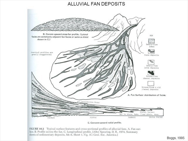
Many of the deposits that you see coming out of mountains and at the base of them are what is called alluvial. Primarily made up of rock and soil brought down by rain deposits. They are deposited in layers slowly over time forming a fan. The sedement departs the canyon, and then lays down materials, when that gets too high the course changes and it starts depositing over another locaition.

This roadcut is in the location of an old deposit.
The layers are uneven, cut into each other as floods and erosion takes place before more is deposited to fill those washes. Geologists can use the layers from a cut to determine what zone of the alluvial plane this was taking place in.

Image by From Stell and Gloppen (1980).
Proximal
This is made of up Large stones, small to large boulders. These materials will not have traveled as far and will not be heavily erodid. They will be as layered as the later locations in the plain as they just tumble upon each other and stop.
Mid Fan
These will be layered with differet types and smaller. Gravel will be washed out during large floods, while finer sediment may be deposited during a steady flow of water. It will not always be gravel/sand/gravel/sand, but could be flows of fine sand upon each other, floods, clays, sand etc. You may be broken up with a nonconformity as a flood tears one big cut through the fan and fills later, but generally this is steep enough that most water will still be flowing outward
Distal
In the distal cross sections is where you are getting the flattest. Water will start to move outward, a meandering point. So the cross sections will show many small mounded deposits, troughs and cross beds.