Now a Parish of approximately 2000 acres with 670 homes and population of around 1600, located almost at the mid-point between Kings Lynn, Bury St Edmunds and Norwich; Mundford enjoys a very rural position at the centre of the ‘Brecklands’ region and within the boundaries of the Thetford Chase Forest.
60,000 years ago when Neanderthals butchered mammoth in what is now Lynford Water, the middle Palaeolithic River Valley; through to 3000 years ago when Neolithic flint axes were produced by the thousands at nearby Grimes Graves, to be traded across Europe, Mundford was, and remains a major crossing point on the River Wissey.
Mund: from the middle English to mean “a natural hill appearing as if thrown up artificially-a regular or isolated hill” and; Ford: “a location where a river is shallow and the bottom has good footing making it possible to cross”
Both for locals and travellers alike, the “Mound by the Ford” was both instantly recognisable, and eagerly sought for on those arduous foot journeys through lands unfamiliar.
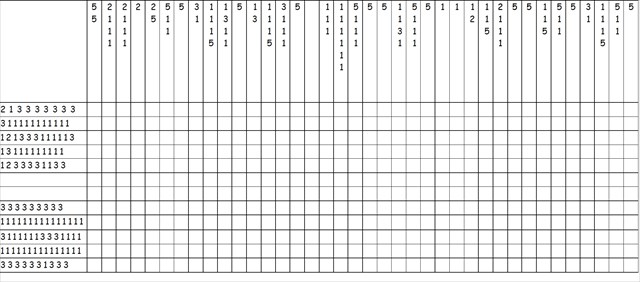
To work out the coordinates for the physical cache, you will need to do a little ‘painting by numbers’ – enjoy!
You can check your answers for this puzzle on GeoChecker.com.
If anybody would like to expand this series please do. I would just ask that you let Smokeypugs know first so they can keep track of the Village Sign numbers and names to avoid duplication.