

The only way to log this earthcache is via COPY AND PASTE the template that you will find below, with your asnwers and comentaries. FIRST TEMPLATE and then any comentary that you wanna do on your find. There is no need to e-mail me the answers.
With this Earthcache we are going to study the characteristics of the Sydney Harbour Estuary. It is going to be more off a community work than individual tasks. You will have to fulfill some duties in order to log this cache, and also you will have to check other Geocachers data in order to make your own conclusions. You don't have to e-mail me the answers, just write them on your log so others can see them too.
Hope you enjoy the experience.
SYDNEY HARBOUR ESTUARY
An ESTUARY is a partially enclosed coastal body of brackish water with one or more rivers or streams flowing into it, and with a free connection to the open sea.
Brackish water is water that has more salinity than fresh water, but not as much as seawater. It may result from mixing of seawater with fresh water, as in estuaries. Technically, brackish water contains between 0.5 and 30 grams of salt per litre, while on average, seawater in the world's oceans has a salinity of about 3.5%.
Estuaries form a transition zone between river environments and maritime environments. They are subject both to marine influences—such as tides, waves, and the influx of saline water—and to riverine influences—such as flows of fresh water and sediment. The inflows of both sea water and fresh water provide high levels of nutrients both in the water column and in sediment, making estuaries among the most productive natural habitats in the world.
The most important variable characteristics of estuary water are the concentration of dissolved oxygen, salinity and sediment load. There is extreme spatial variability in salinity, with a range of near zero at the tidal limit of tributary rivers to 3.4% at the estuary mouth. At any one point the salinity will vary considerably over time and seasons, making it a harsh environment for organisms.
Most existing estuaries formed during the Holocene epoch with the flooding of river-eroded or glacially scoured valleys when the sea level began to rise about 10,000–12,000 years ago.
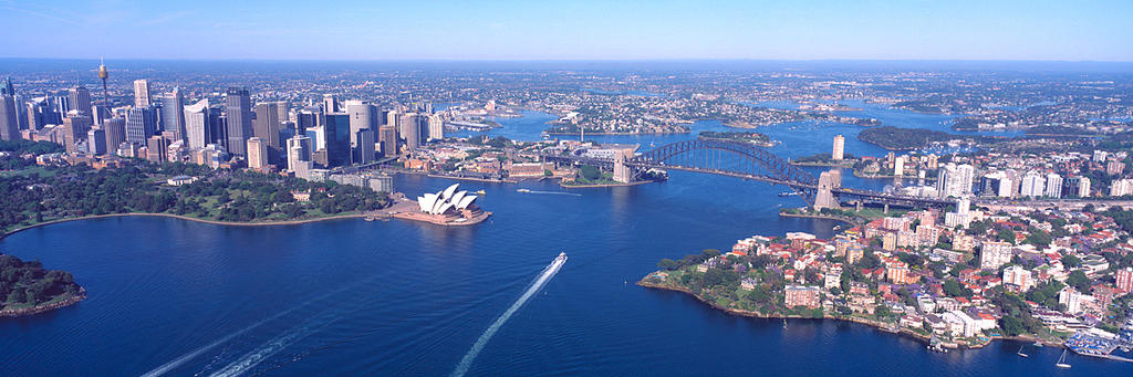
Sydney Harbour is unarguably Australia’s most iconic estuarine system, it is renowned for its natural beauty and this beauty emanates from the complexity of inlets formed by the drowning of a river valley. Sydney Harbour hosts a diversity of marine habitats and associated biodiversity. This estuary is also one of the most modified estuaries in the word. It is home to a growing urban centre of 4 million people, > 50% of the foreshore has been armoured, 90% of the catchment is urbanized or industrialized and it is infamous with regards to the extent of metal contaminants in benthic sediments and macroalgae.
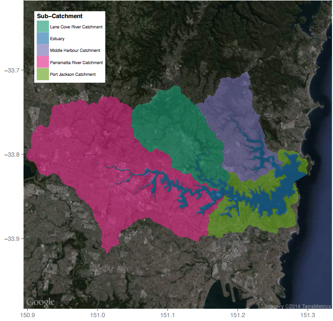
The Harbour is a drowned river valley which formed during the sea level rise approximately 10,000 years ago. The entrance is approximately 3 km wide with a depth of up to 30 m. From the entrance to Sydney Harbour, the estuary opens up to form Port Jackson, and then extends into three main branches, Middle Harbour to the north and the Parramatta and Lane Cove Rivers extending south, then westward away from the heads. The Parramatta River, Lane Cove and Middle Harbour are major tributaries joining the main estuary channel. The estuary, which has a complex shoreline and topography, is approximately 30 km long, with a surface area of about 50 km2 and a total catchment of 500 km2.
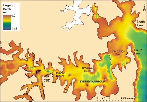
The bathymetry (the measure of depth) of Sydney Harbour is complex, the estuary consists of a number of large, shallow, bays adjacent to the main channel which represent a large reservoir for tidal waters. The present-day estuary comprises six environmental or sedimentological units, including the harbour entrance (marine flood-tide delta sands), lower estuary (sands), central estuary (muddy sands) and upper estuary (muds) and the off-channel embayments (muds).
Current speeds offshore can be up to 1.5 m/s in as little as 65m of water, meaning that water flowing past the entrance to the harbour is continually being renewed and replenished.
There are three dominant wind patterns affecting Sydney Harbour, the strongest winds (occurring 17% of the time) are from the south. The most frequently observed direction was from the northeast (22% of the time), although not as strong as the winds from the south. The third most common wind pattern was from the west, occurring primarily during winter (18% of the time).
SALINITY IN THE SYDNEY ESTUARY
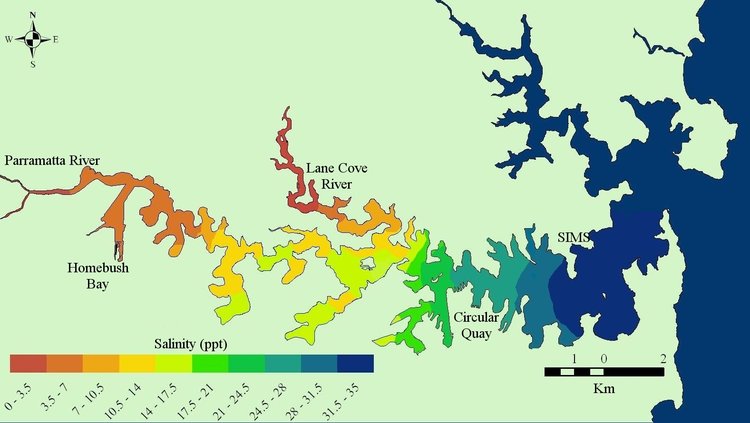
Salinity in Sydney Harbour is modified by precipitation, freshwater inflow and evaporation. During dry periods the estuary is well mixed (ocean salinity ~35 psu). In heavy rainfall, salinity may drop substantially in the top 1-2 m of water, due to the freshwater in the rain and running off the land.
The balance between freshwater inflow, precipitation and evaporation modifies salinity concentrations in the estuary. Rainfall in the Sydney catchment is characterised by dry conditions, punctuated by infrequent, high-precipitation events (rainfall > 50 mm.day−1). During dry-weather (rainfall < 5 mm.day−1), the estuary is well-mixed (normal ocean salinity). A small, highly-urbanised (86 %) catchment and extensive impervious surfaces result in rapid runoff during high-precipitation events. Stormwater reaching the estuary under these conditions forms a buoyant layer one to two metres thick above saline estuarine waters.
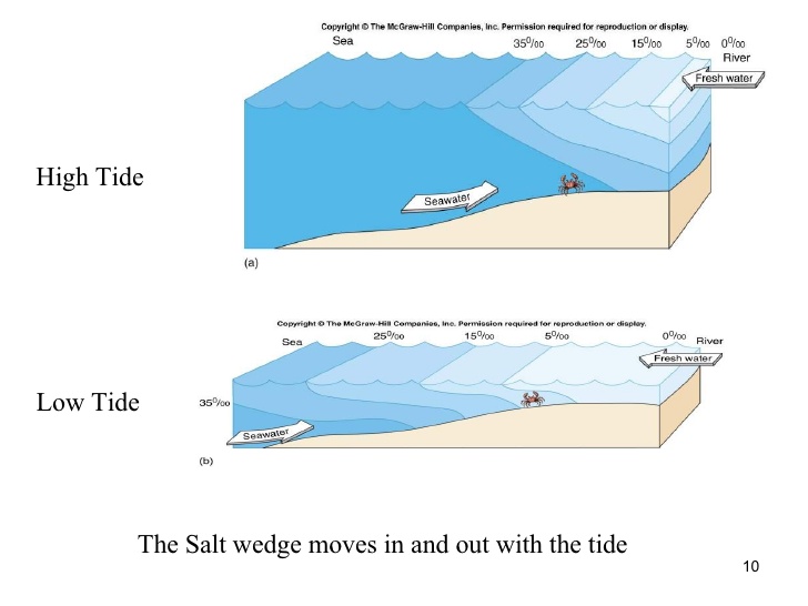
High tide brings in ocean water, causing a rise in salinity. During low tide, ocean water recedes, causing a drop in salinity. Weather can affect the salinity directly at the estuary or through streams that flow from the mountains.
Circulation of the water in Sydney Harbour is dominated by the tides, which are periodic and reverse every 6 hours. Tidal flow is strongest near the northern side of the harbour entrance, and clockwise eddies are formed. Here, tidal velocities can be up to 0.25 ms-1 in surface waters. Discharge volumes are around 6000 m3 .s-1 near the heads on an ebb tide. Water age can vary between 20 d in the main body of the harbour, to 130 d in the upper reaches.
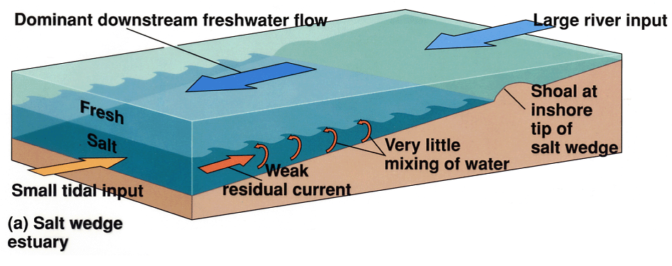
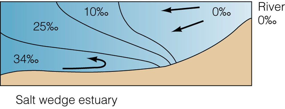
The daily mixing of fresh water and saltwater in estuaries leads to variable and dynamic chemical conditions, especially salinity. When fresh water and saltwater meet in an estuary, they do not always mix very readily. Because fresh water flowing into the estuary is less salty and less dense than water from the ocean, it often floats on top of the heavier seawater. The amount of mixing between fresh water and seawater depends on the direction and speed of the wind, the tidal range (the difference between the average low tide and the average high tide), the estuary’s shape, and the volume and flow rate of river water entering the estuary. These factors are different in each estuary, and often change seasonally within the same estuary. For example, a heavy spring rain, or a sustained shift in local winds, can drastically affect the salinity in different parts of an estuary.
LOGGING TASK
Choose one area around any of the TEN WAYPOINTS suggested as they represent different sections of the body of the estuary (on each waypoint I mentioned some entry point where water is easily and safe accessed. There is no need to go exactly to the pin location as they are in the middle of the water, do not take any risk to do this task), and take a sample of the water. When possible, if there is any wharf or similar, try to take the sample as far from the shallow shore as possible. Measure the salt dissolved in the sample and fill the template on your log so the next Geocachers could see your data and compare it with yours.
Measuring Total Dissolved Salts (TDS)
To calculate Total Dissolved Salts, you will need to accurately measure 1L of water. To calibrate your bottle to 1L (1000mls), collect your water sample, and weigh it on a set of scales to equal 1k (1000g). Remember to factor in the weight of your bottle/container when you do this.
1000mls = 1000g
Pour the water into a pot, and place it on a stove to evaporate ALL the water. Carefully remove the remaining salt left behind, and use the following formula to calculate TDS.
Salinity = salt mass (g) / 1000mL
Multiply your result by 100 to turn it into a percentage.
Another way to calculate the percentage of salt is to bring along an Aquarium Hydrometer in order to calculate the density of the water. The density of pure water is 1000 kg/m3. Ocean water is more dense because of the salt in it. Density of ocean water at the sea surface is about 1035 kg/m3. This means that for every 1 litre (1000 mL) of seawater there are 35 grams of salts (mostly, but not entirely, sodium chloride) dissolved in it. Although a vast majority of seawater is found in oceans with salinity around 3.5%, seawater is not uniformly saline throughout the world. With an easy calculation you can determine the grams and percentaje of your sample knowing it's density.
TEMPLATE FOR YOUR LOG
LOCATION OF THE SAMPLE = Name the LOCATION and name the Waypoint - WP1 / WP2 / WP3 / WP5 ... or WP10
SALINITY OF THE SAMPLE = Percentage
HOW WOULD YOU CONSIDER THE SAMPLE = Fresh, SeaWater or Brackish Water
TIDE LEVEL AT THE MOMENT THE SAMPLE WAS TAKEN = Meters
WEATHER CONDITIONS = Previous day's rainfall / Average wind
WHAT WAS YOUR PREDICTION FOR THE SALINITY ON THAT AREA?
DO YOU THINK THAT IF YOU TAKE ANOTHER SAMPLE ON YOUR AREA BUT A MUCH DEEPER LEVEL THE SALINITY WOULD BE THE SAME? OR WILL IT HAVE HIGHER/LOWER SALINITY?
COMPARE YOUR RESULTS (IF POSSIBLE) WITH THE RESULTS OF PREVIOUS LOGS IN THAT AREA
COMPARE YOUR RESULTS WITH THE RESULTS OF PREVIOUS LOGS OF A CLOSE AREA
WHAT DO YOU THINK ARE THE REASONS FOR THE DIFFERENCE/SIMILARITIES ON THE DATA?
TO CHECK THE TIDES - LINK (http://tides.willyweather.com.au/nsw/sydney/fort-denison.html )
TO CHECK THE METEOROLOGY CONDITIONS (RAINFALL, TEMPERATURE, WIND, ...) - LINK (http://www.bom.gov.au/nsw/observations/sydney.shtml )
References:
http://sims.org.au/wp-content/uploads/2014/08/SIMS-Harbour-Report_final_web-lowres1.pdf
http://sims.org.au/about-sydney-harbour/
https://en.wikipedia.org/wiki/Estuary
https://en.wikipedia.org/wiki/Brackish_water