Opis miejsca:
Nazwa Askaukalis pojawia się w dziele „Geografia” napisanym przez Klaudiusza Ptolemeusza – najsłynniejszego geografa i astronoma starożytności w połowie II wieku. Autor zawarł w nim całą wiedzę geograficzną o ówczesnym świecie. W Barbaricum – obszarze Europy poza granicami Cesarstwa Rzymskiego podaje on nazwy najważniejszych, znanych mu miejscowości, usytuowanych liniowo wzdłuż szlaków handlowych. Askaukalis wraz z Kalisią i Setidavą figuruje w jednej z takich linii. Są to najstarsze nazwy miejscowości na obszarze ziem polskich znane ze źródeł pisanych. Po upływie prawie dwudziestu wieków Julian Pater – mieszkaniec Kruszy Zamkowej znalazł na swoim polu doskonale zachowaną srebrną monetę. Był to denar wybity za panowania cesarza Antonina Piusa, sprawującego rządy w latach 138-161, a więc w czasie ukazania się dzieła Ptolemeusza. W latach 1973-1977 na polu odkrywcy (Juliana Patera) przeprowadzone zostały archeologiczne badania wykopaliskowe kierowane przez Profesor Aleksandrę Coftę-Broniewską z Instytutu Prahistorii Uniwersytetu im. Adama Mickiewicza w Poznaniu. W wyniku tych badań odsłonięto pozostałości rozległej, unikanej osady z przełomu starej i nowej ery. Na tej podstawie inicjatorka badań – Aleksandra Cofta-Broniewska sformułowała śmiałą hipotezę utożsamiającą tę osadę z ptolemeuszowym Askaukalis. Po kilkudziesięcioletniej przerwie badania zostały wznowione. Ich nadrzędnym celem jest konieczność uchronienia tego obiektu – unikalnego dla dziedzictwa kulturowego społeczności Kujaw przed rabunkiem przez nielegalnych „poszukiwaczy skarbów”, posługujących się wykrywaczami metali.
Na przełomie starej i nowej ery w wyniku ekspansji rzymskiej dochodzi do podziału Europy na dwa różne światy: cywilizacji antycznej i Barbaricium. Granicę (limes) pomiędzy nimi – na okres prawie 400 lat wyznaczają rzeki Dunaj i Ren. Oba światy połączone są jedną z najważniejszych dróg świata starożytnego – szlakiem bursztynowym. Prowadzi on z Akwileji nad Morzem Śródziemnym – przez Kujawy – ku południowemu wybrzeżu Bałtyku, zasobnemu w bursztyn. Krusza Zamkowa – wieś w Polsce położona w województwie kujawsko-pomorskim, w powiecie inowrocławskim, w gminie Inowrocław. W latach 1975-1998 miejscowość administracyjnie należała do województwa bydgoskiego. Osada w Kruszy Zamkowej miała wyjątkowy charakter. Znajdowało się tu centrum władzy regionu Kujaw, główny ośrodek religijny oraz ośrodki wyspecjalizowanej wytwórczości, funkcjonujące przez blisko 600 lat (II w. p. n. e.). Osada usytuowana była na wzniesieniu, u zbiegu dolin Noteci i Smyrni, w miejscu najdogodniejszej przeprawy przez szeroką, tworzącą liczne rozlewiska dolinę Noteci. Obszar osady podzielony był na dwie różne strefy. Pierwszą tworzyła część mieszkalna, w obrębie której znajdowały się punkty wymiany handlowej, sanktuarium, siedziby arystokracji plemiennej, a także domy rzemieślników trudniących się obróbką bursztynu, poroża oraz metalurgią kolorową (jubilerstwem), garncarstwem i tkactwem. Odkryto tu liczne relikty budynków, piwniczek, pieców i innych urządzeń gospodarczych oraz bardzo dużą ilość narzędzi, ozdób i innych przedmiotów wykonanych z żelaza, brązu, srebra, bursztynu, kości i poroża, a także ogromną kolekcję naczyń ceramicznych. Szlak bursztynowy zaczynał się od Rzymu przez naddunajskie faktorie, Czechy i Morawy, na Śląsk do Opola a dalej do Kalisza i przez rzekę Wartę w rejonie Konina. Centralny punkt osadniczy kujawskiego odcinka szlaku bursztynowego usytuowany był w rejonie Kruszy Zamkowej. Osady obsługujące szlak bursztynowy rozmieszczone są na jego przebiegu w regularnych odstępach mniej więcej, co 20 km od siebie. Na odcinku Konin – Otłoczyn istniało pięć takich skupień, zlokalizowanych w rejonie Paniewa, Kościeszek, Kruszy Zamkowej oraz Kaczkowa i Opok. Poszczególne skupienia pełniły funkcje punktów gdzie zatrzymywali się podróżni wędrujący szlakiem bursztynowym i wymieniali towary. Ostatnim punktem kujawskiego odcinka szlaku bursztynowego była osada Otłoczyn obsługująca przeprawę przez bród na Wiśle.
Jeśli chcesz dowiedzieć się więcej, zachęcamy do odwiedzenia Centrum Dziedzictwa Kujaw Zachodnich w Łojewie (Centrum Dziedzictwa Kujaw Zachodnich (GC6VAND) lub TB Hotel w Sercu Kujaw Zachodnich (GC6V49Y). W sali „Askaukalis” poznasz arcyciekawą historię najstarszej polskiej wsi – Kruszy Zamkowej, słynnego Askaulalis, emporium z okresu rzymskiego, położonego na Szlaku Bursztynowym. "Centrum" czynne w podanych dniach i godzinach:
Poniedziałek – Piątek w godz. 7:30 – 15:30.
Sobota-niedziela możliwa po uzgodnieniu telefonicznym (Tel. +48 52 351 05 75)

Skrytka:
Na kordach startowych odszukaj kilka miejsc i zbierz potrzebne informacje.
Klasyczna Świątynia Antyczna
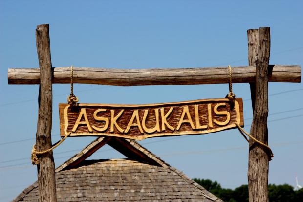
Obok świątyni na drewnianej tablicy widnieje napis. Policz wszystkie litery "Ó", ich ilość to Twoje X.
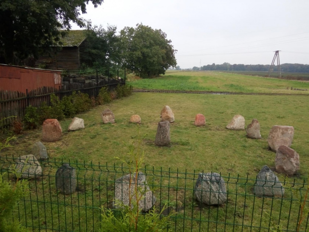
Askaukalis - Aglomeracja Osadnicza
Zapoznaj się z tablicą informacyjną i wykonaj działania matematyczne: liczbę bryłek surowca, półwytworów paciorków z różnych faz obróbki podziel przez liczbę odkrytych różnych punktów osadniczych, wynik zaokrąglij do pełnej liczby zgodnie z zasadami matematyki. Zaokrąglona liczba to Twoje Y.
Krusza Zamkowa - Sanktuarium
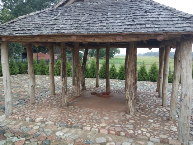
Przy ścianie na wprost wejścia znajdował się ołtarz w formie kręgu o średnicy 30 cm, wyniesiony lekko nad poziom posadzki. Będąc na miejscu przy użyciu miary dokonaj pomiaru średnicy obecnego ołtarza (wewnętrzne wgłebienie, przy samym dnie, jest to odrobine mniej niż 30cm). Wynik w centymetrach to Twoje Z.
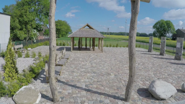
Krusza - Osada Centralna
Otrzymany wynik A podziel przez ilość "Naczyń z brązu i szkła" przedstawionych na tablicy. Wynik to Twoje B.
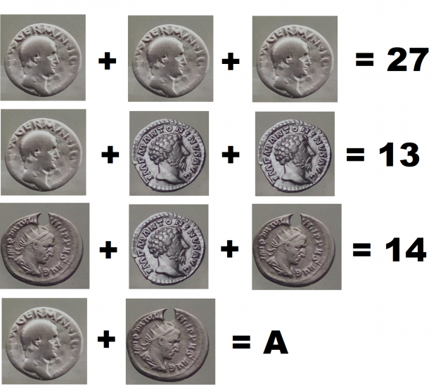
Askaukalis - Na Mapie Ptolemeusza
Julian Pater – mieszkaniec Kruszy Zamkowej znalazł na swoim polu doskonale zachowaną srebrną monetę. Był to denar wybity za panowania cesarza Antonina Piusa, sprawującego rządy w latach ... Dodaj wszystkie cyfry do siebie, a otrzymasz C.
Mając wszystkie dane podstaw do wzoru:
N 52° 44.4 (Y+Z+C-A-B+X/3)
E 018° 13. B (Y+Z+A-X-B)
Zamknij szczelnie pojemnik i zachowaj maskowanie. Jeśli miejsce w logbooku się kończy daj mi znać o tym wcześniej, abym mógł zaplanować wizytę serwisową.
Koordynaty +/- 5m. Powodzenia :-)
Place description:
Askaukalis name appears in the book "Geography" written by Claudius Ptolemy - the most famous geographer and astronomer of antiquity in the middle of the second century. The author has included in its entire geographical knowledge of the contemporary world. In Barbaricum - in Europe outside of the Roman Empire gives it name the most important, he knew the village, located linearly along the trade routes. Askaukalis with Kalisia and Setidavą appear in one of these lines. These are the oldest name of the village in the Polish territories known from written sources. After almost twenty centuries Julian Pater - resident of Krusza Zamkowa found in his field well-preserved silver coin. This was the denarius minted during the reign of the Emperor Antoninus Pius, holding governments in the years 138-161, and so during the show the works of Ptolemy. In the years 1973-1977 in the field of explorers (Julian Pater's) were carried out archaeological excavations directed by Professor Aleksandra Cofta-Broniewska of the Institute of Prehistory of Adam Mickiewicz University in Poznan. As a result of these studies uncovered the remains of a vast, unique settlement from the turn of the old and the new era. On this basis, the initiator of the study - Alexander Cofta-Broniewska formulated a bold hypothesis identifying the settlement of ptolemeuszowym Askaukalis. After decades of break tests were resumed. Their ultimate goal is the need to protect the building - a unique cultural heritage community Kujaw against pillage by illegal "treasure hunters", who use metal detectors.
At the turn of the old and the new era as a result of the expansion of the Roman it comes to the division of Europe into two different worlds: the ancient civilization and Barbaricium. Border (limes) between them - for a period of almost 400 years set the river Danube and the Rhine. Both worlds are connected to one of the most important routes of the ancient world - the Amber Route. It leads from Akwileji on the Mediterranean Sea - through Cuiavia - towards the south coast of the Baltic Sea, rich in amber. Krusza Zamkowa - a village in Poland located in the Kuyavian-Pomeranian district of Inowrocław, in the municipality of Inowrocław. In the years 1975-1998 the town administratively belonged to the province of Bydgoszcz. The settlement in Krusza Zamkowa was unique. It was the center of power here Kujawy region, the main center of religious centers and specialized manufacturing, operating for nearly 600 years (II BC). The settlement was situated on a hill at the confluence of valleys of Notec and Smyrnia, at the most convenient crossing the wide, forming numerous backwaters valley of Notec. The area of the settlement was divided into two different zones. The first created living area, within which there were points of trade, sanctuary, home of the tribal aristocracy, as well as the houses of craftsmen engaged in the processing of amber colored antlers and metallurgy (the jewelery), pottery and weaving. Discovered numerous relics of buildings, cellars, ovens and other equipment business and a very large amount of tools, ornaments and other objects made of iron, bronze, silver, amber, bone and antler, as well as a vast collection of pottery. Amber Road started from Rome on the Danube factories, Bohemia and Moravia, Silesia, Opole and further to Kalisz and the Warta river in the region of Konin. The central point of settlement Cuiavian section of the Amber Road was located in the area of Krusza Zamkowa. Sediments support amber route are distributed on its progress at regular intervals of approximately every 20 km from each other. Section Konin - Otłoczyn there were five such clusters, located in the region of Paniewa, Kościeszki, Krusza Zamkowa and Kaczków and Opoki. Particular focus points where the functions when travelers wandering trail of amber and exchanged goods. The last point of Cuiavian section of the Amber Road was a settlement Otłoczyn supports crossing by ferry on the Vistula.
If you want to learn more, we encourage you to visit the Heritage Centre of Western Cuiavia in Łojewo (Centrum Dziedzictwa Kujaw Zachodnich (GC6VAND) lub TB Hotel w Sercu Kujaw Zachodnich (GC6V49Y). The room "Askaukalis" know the very interesting story of the oldest Polish village - Krusza Zamkowa, the famous Askaulalis, emporium of the Roman period, located on the Amber Route. "Center" open the indicated days and times:
Monday - Friday in hours. 7:30 - 15:30.
Saturday-Sunday possible by appointment (Tel. +48 52 351 05 75)
The cache:
At starting cords locate several places and gather the information you need.
Classic Ancient Temple
Next to the temple on a wooden plate inscription. Count all of the letters "Ó", their number is your X.
Askaukalis - Settlement Agglomeration
Refer to the information board and perform mathematical operations: the number of lumps of raw materials, półwytworów beads of different phases of the treatment divide by the number of outdoor different points of settlement, round the result to the number of full compliance with the principles of mathematics. The rounded number is your Y.
Krusza Zamkowa - Sanctuary
Against the wall opposite the entrance was an altar in the form of a circle with a diameter of 30 cm, slightly elevated above the floor level. Being on the spot using the measurement, measure the diameter of the current altar (internal cavity, low level, it's nearly lower than designed 30cm). Result in centimeters is your Z.
Krusza - Central Village
The result is a divide by the number of "Dish of bronze and glass" shown in the table. The result is your B.
Askaukalis - On The Map Ptolemy
Julian Pater - resident Crumbles Castle found in his field well-preserved silver coin. This was the denarius minted during the reign of the Emperor Antoninus Pius, holding governments in years ... Add all the numbers together, and you get C.
Having all data calculate the formula:
N 52° 44.4 (Y+Z+C-A-B+X/3)
E 018° 13. B (Y+Z+A-X-B)
Close the container tightly and keep masking. If in the logbook ends let me know about it before, so I can plan a service call.
Coordinates +/- 5m. Good luck :-)
Ortsbeschreibung :
Askaukalis Name wird in dem Buch "Geographie", geschrieben von Claudius Ptolemäus - der berühmteste Geograph und Astronom der Antike in der Mitte des zweiten Jahrhunderts. Der Autor hat in seiner gesamten geographischen Kenntnisse der modernen Welt enthalten. In Barbaricums - in Europa außerhalb des Römischen Reiches verleiht nennen es das wichtigste, er das Dorf wusste, befindet sich linear entlang der Handelswege. Askaukalis mit Kalisia und Setidavą in einer dieser Linien erscheinen. Es handelt sich um die älteste Name des Dorfes in den polnischen Gebieten aus schriftlichen Quellen bekannt. Nach fast zwanzig Jahrhunderten Julian Pater - Bewohner von Krusza Schloss in seinem Gebiet gefunden Silbermünze gut erhalten. Dies war der Denar während der Herrschaft des Kaisers Antoninus Pius geprägt, die Regierungen in den Jahren 138-161, und so während der Show der Werke von Ptolemäus zu halten. In den Jahren 1973-1977 auf dem Gebiet der Entdecker (Julian Paters) wurden archäologische Ausgrabungen von Professor Alexander Cofta-Broniewska des Instituts für Urgeschichte von Adam-Mickiewicz-Universität in Poznan gerichtet durchgeführt. Als Ergebnis dieser Studien die Überreste eines riesigen, einzigartigen Siedlung aus der Wende der alten und der neuen Zeit freigelegt. Auf dieser Basis der Initiator der Studie - Formuliert Alexander Cofta-Broniewska eine kühne Hypothese die Ansiedlung von ptolemeuszowym Askaukalis identifizieren. Nach Jahrzehnten der Pause Tests wurden wieder aufgenommen. Ihr oberstes Ziel ist die Notwendigkeit, das Gebäude zu schützen - ein einzigartiges kulturelles Erbe Gemeinschaft Kujaw gegen Plünderungen durch illegale "Schatzsucher", die Metall-Detektoren verwenden.
An der Wende der alten und der neuen Zeit als Folge der Ausdehnung des Römischen es in zwei verschiedenen Welten zu der Teilung Europas kommt: die alte Zivilisation und Barbaricium. Border (Limes) zwischen ihnen - für einen Zeitraum von fast 400 Jahren ist die Donau und den Rhein gesetzt. Beide Welten sind zu einem der wichtigsten Routen der alten Welt verbunden - der Bernsteinstraße. Er führt von Akwileji am Mittelmeer - durch Cuiavia - in Richtung der Südküste der Ostsee, die reich an Bernstein. Krusza Burg - ein Dorf in Polen in der Kujawien-Pommern Kreis Inowrocław, in der Gemeinde Inowrocław. In den Jahren gehörte 1975-1998 die Stadt administrativ der Provinz Bydgoszcz. Die Siedlung in Krusza Burg war einzigartig. Es war das Zentrum der Macht hier Kujawien, das wichtigste Zentrum der religiösen Zentren und spezialisierte Fertigung, für fast 600 Jahre (II BC) arbeitet. Die Siedlung wurde auf einem Hügel an der Mündung der Täler von Notec und Smyrna gelegen, am besten die große Kreuzung, zahlreiche Stau Tal Noteć bilden. Die Fläche der Siedlung wurde in zwei verschiedene Zonen unterteilt. Der erste Wohnbereich geschaffen, in denen es Punkte des Handels waren, Heiligtum, der Heimat des Stammes-Aristokratie, sowie die Häuser in der Verarbeitung von bernsteinfarbenen Geweih und Metallurgie (der Schmuck), Töpferei und Weberei beschäftigt Handwerker. Entdeckt zahlreiche Reliquien von Gebäuden, Kellern, Öfen und anderen Geräten Geschäft und eine sehr große Menge an Werkzeugen, Schmuck und andere Gegenstände aus Eisen, Bronze, Silber, Bernstein, Knochen und Geweih, sowie eine große Sammlung von Keramik. Bernsteinstraße begann von Rom an der Donau Fabriken, Böhmen und Mähren, Schlesien, Oppeln und weiter oben nach Kalisz und der Warthe in der Region Konin. Der zentrale Punkt der Siedlung Cuiavian Abschnitt der Bernsteinstraße wurde im Bereich der Krusza Burg. Sediments Unterstützung Bernsteinstraße sind über die Fortschritte in regelmäßigen Abständen von jeweils etwa 20 km voneinander verteilt. Abschnitt Konin - Otłoczyn gab es fünf trockenen Cluster, in der Region von Paniewa, Kościeszki, Krusza Schloss und Kaczków und Felsen. Besondere Schwerpunkte, wo die Funktionen, wenn Reisende und wandernde Spur von Bernstein und tauschten Waren. Der letzte Punkt der Cuiavian Abschnitt der Bernsteinstraße war eine Siedlung Otłoczyn unterstützt mit der Fähre an der Weichsel überqueren.
Wenn Sie mehr erfahren möchten, in Sie ermutigen, das Heritage Centre of Western Cuiavia in Łojewo (Heritage Centre of Western Kujawien (GC6VAND) oder TB-Hotel im Herzen der westlichen Kujawien (GC6V49Y). Das Zimmer "Askaukalis" kennen die sehr interessante Geschichte zu besuchen von das älteste polnische Dorf - Krusza Schloss, das berühmte Askaulalis, Emporium aus der Römerzeit zeit, befindet sich auf der Bernsteinstraße "Center" öffnen Sie die angegebenen Tagen und Zeiten.
Montag - Freitag in den Stunden. 7.30 bis 15.30 Uhr.
Samstag-Sonntag nach Vereinbarung möglich (Tel. +48 52 351 05 75)
Der cache:
Bei Start Schnüre finden mehrere Orte und sammeln die Informationen, die Sie benötigen.
Klassische Antike Tempel
Neben dem Tempel auf einer hölzernen Platte Inschrift. Zählen Sie alle Buchstaben "Ó" Ihre Zahl ist Ihre X.
Askaukalis - Settlement Agglomerations
Wenden Sie sich an der Informationstafel und führen mathematische Operationen: die Anzahl der Klumpen von Rohstoffen, półwytworów Perlen in verschiedenen Phasen der Behandlung dividiert durch die Anzahl der im Freien verschiedenen Standpunkten Siedlung, um die Folge der Anzahl der vollständigen Einhaltung der Grundsätze der Mathematik. Die abgerundete Zahl ist Ihre Y.
Krusza Zamkowa - Sanctuary
An der Wand gegenüber dem Eingang war ein Altar in Form eines Kreises mit einem Durchmesser von 30 cm, leicht über dem Bodenniveau erhöht. Als auf der Stelle die Messung an, messen Sie den Durchmesser des aktuellen Altar (inneren Hohlraum, niedrigen Niveau, es ist fast niedriger als entworfen 30cm). Ergebnis in Zentimetern ist Ihr Z.
Krusza - Central Village
Das Ergebnis ist eine Division durch die Anzahl der "Dish aus Bronze und Glas" in der Tabelle dargestellt. Das Ergebnis ist Ihr B.
Askaukalis - Auf der Landkarte Ptolemäus
Julian Pater - resident zerbröckelt Schloss gefunden in seinem Gebiet gut erhaltene Silbermünze. Dies war der Denar während der Herrschaft des Kaisers Antoninus Pius geprägt, die Regierungen in Jahren ... In alle Zahlen zusammen, und Sie bekommen C.
Nachdem alle Daten berechnen die Formel:
N 52° 44.4 (Y+Z+C-A-B+X/3)
E 018° 13. B (Y+Z+A-X-B)
Wenn Sie etwas aus dem Cache zu nehmen möchten, lassen Sie etwas im Gegenzug zu Safe gemacht Vergnügen eines anderen Suchenden . Schließen Sie den Behälter fest und halten Maskierung. Wenn im Logbuch Enden lassen Sie es mich wissen, bevor, so kann ich einen Service planen.
Koordinaten +/- 5m. Viel Glück :-)

