Stepper Point
Stepper Point is on the North Cornish coast, just North of Padstow.
Its name in Cornish is Penn Stupper.
You can access the area from various points. The easiest way is to head to Lellizzick. Park up in the car park, on the right hand side and clearly marked, which currently charges £2. You can park on the side of the road as you head toward Lellizzick, but it is very limited. There is no parking in Hawker’s Cove. Then walk to Hawker’s Cove and follow the footpath signs to the coast path. From here you follow the main path until you come to an open area and a post with The Narrows written on it (SX 914 780). This is where the path splits. Take the right path down to Stepper Point. The left path takes you up to the lookout station and the main footpath. There are caches on the way for those who haven’t visited the area before.
Please note, that the wetland area to the left hand side of where the post is, is an SSSI and it is against the law to damage it in any way.
Tasks & Questions:
1- As you stand here at the headline coordinates, you will see 3 lines of a white mineral in the rock. What is the mineral, and give a brief description of crystal sizes within it. What compass direction does it run?
2- Carry on around to the small hut. With the sea to your back, go to the left hand side of the hut. In the rocks behind, you will see more of the white mineral. Describe the way this is in the rock, and give a brief description why you think it is this way.
3- At the marked waypoint, you will a wall of grey and purple slate. According to the description, this is wrong. Why is this? What do you think is the reason for it?
Geology:
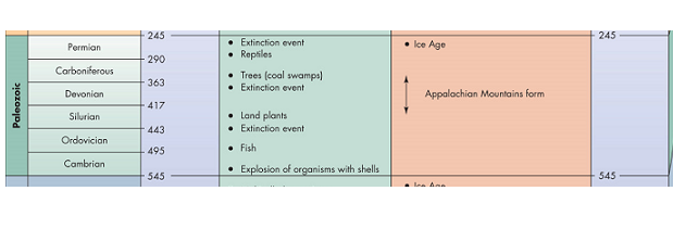
The rocks in the area are Igneous bedrock, formed approximately 299-416 million years ago. This was in the Carboniferous period to the Devonian period.
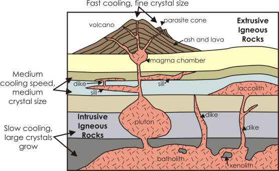
The rocks were formed from Silica Poor Magma, which intruded into the Earth’s crust. As it cooled, they formed intrusions ranging from large coarse-crystalline Gabbroic rocks, to fine to medium crystalline rocks, which are often Basaltic dykes and sills.
The difference between a dyke and a sill is that the dyke formed in a fracture in existing rock, and is usually vertical or diagonal. A sill is usually horizontal and sits between layers of rock, where it has intruded. It can intrude in sedimentary rock or in beds of volcanic rock and even in metamorphic rock.
Other rocks here are also Sedimentary bedrock, formed 359-385 million years ago. This was during the Devonian period. These are referred to as Polzeath Slate Formation, a mixture of mudstone, siltstone and sandstone.
These rocks were formed on a deep ocean floor, and often consist of fine materials from microscopic pelagic organisms. (Information from the BGS).
Pelagic sediment is a fine-grained sediment that accumulates as the result of the settling of particles to the floor of the open ocean, far from land. These particles consist primarily of either the microscopic, calcareous or siliceous shells of phytoplankton or zooplankton.
Pelagic is derived from material that has fallen to the bottom from the upper waters of the sea.
History:
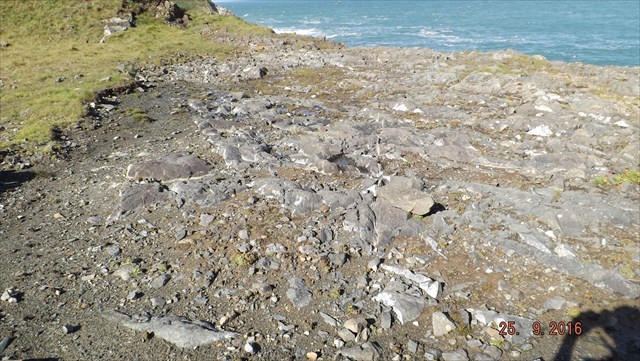
This particular area is the site of an old quarry.
The rock being exploited was a “greenstone” or dolerite.
Dolerite is similar to basalt in that it is a basic volcanic rock but the crystals are often visible indicating a gradual cooling. Often dolerite has been the reservoir for extrusive basaltic rocks extruded from a volcano. These rocks often have a greenish hue due to the presence of the green mineral olivine. As intrusive rocks they often occur as dykes or sills. The mineral composition is mainly of olivine, augite and plagioclase feldspars, and it has a low silica content.
The dolerite rock now seen in the quarry was once part of a magma chamber for a sub-sea volcano during the Devonian Period. This basaltic igneous rock has intruded into marine sediments, the contact of which can be seen near the entrance to the quarry. The marine sediments have been folded and metamorphosed into purple and green slates. Evidence of the compression is seen in tension quartz veins that have formed in low-pressure regions. At the contact with the dolerite the slates have been thermally metamorphosed by the hot igneous intrusion.
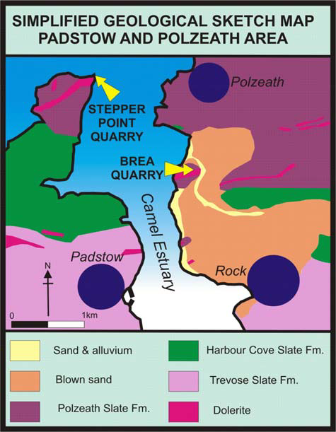
Some of the differences in the slates quarried here are in the colour.
Harbour Cove slate is grey with occasion purple bands within the grey. It is older than Polzeath slate, mentioned in the map above and is from the early Upper Devonian period.
Polzeath slate is purple and green, and contains iron. It is younger than Harbour Cove slate, and is also from the Upper Devonian period.
Trevose slate is a paler grey than Harbour Cove slate, with darker grey patches within. This was formed in the Middle Devonian period, and makes it older than the other two slates.
To claim this earthcache, please send your answers to me via message centre OR email through my profile. You can log as found, but I will message you if you don't send your answers or there are any issues with your answers.
At the headline coordinates, you will see a patch of black rock on the ground. (See photo)
Tasks & Questions:
1- As you stand here at the headline coordinates, you will see 3 lines of a white mineral in the rock. What is the mineral, and give a brief description of crystal sizes within it. What compass direction does it run?
2- Carry on around to the small hut. With the sea to your back, go to the left hand side of the hut. In the rocks behind, you will see more of the white mineral. Describe the way this is in the rock, and give a brief description why you think it is this way.
3- At the marked waypoint, you will a wall of grey and purple slate. According to the description, this is wrong. Why is this? What do you think is the reason for it?
Although photos are no longer a requirement for Earthcaches, please include a photo/photos of you/other group members at the site, with any feature or the sea in the background.