
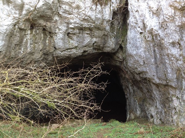
Juranska peć smještena je zapadno od sela Jurana kraj Oriča u općini Pićan. Njezin vanjski otvor impozantnih je dimenzija. U Juranskoj peći može se naći led, koji se zna zadržat do kasno u proljeće. Ljeti su velike razlike u temperaturi vani-unutra. Nalazi se na krškom terenu.
Što je krš?
Krš je skup reljefnih oblika koji su produkti kemijskog trošenja (korozije) stijena topivih u vodi (karbonatne stijene, gips, kamena sol) tj. spektar reljefnih oblika razvijenih u karbonatnim formacijama koje najčešće čine kalcijev (CaCO3) i magnezijev (MgCO3) karbonat.
Obzirom na takav kemijski sastav karbonatne stijene se nazivaju vapnenci i dolomiti, a njihovo svojstvo topivosti u vodi omogućuje stvaranje krša.
Krš je dakle općeniti naziv za skup morfoloških, hidroloških i hidrogeoloških značajki terena koji su izgrađeni od stijena topivih u vodi.
Glavnu ulogu u oblikovanju krškog reljefa imaju kemijski procesi. Dakako da se tu još uključuju tektonika i mehanički procesi, ali bez kemijskih procesa ne bismo govorili o krškome reljefu. Krški je reljef rezultat kemijskoga trošenja stijena Najvažniji uvjet za odvijanje procesa okršavanja jest topivost karbonatnih stijena u vodi. Te stijene doduše izgledaju vrlo čvrsto i otporno, ali voda ih nagriza. To se nagrizanje (kemijsko trošenje, korozija) ne događa na očigled, nego tijekom dugog niza godina.
Zbog korozije u kršu ima vrlo mnogo šupljina. Prošupljenost je jedno od glavnih obilježja stijena krških prostora. Tako nastaju brojne spilje, jame i drugi oblici.
Osnovno obilježje krškog reljefa je selektivna topivost stijena u vodama koje sadrže karbonatnu kiselinu. Ta se topivost ne ostvaruje trenutno, nego kroz dugi niz godina, a propusnost nije poput one koju imaju spužvaste tvari (karbonati nisu mekani), nego nagrizanjem nastaju pukotine zbog kojih stijena više ne može zadržavati vodu.
Posljedica toga je nastajanje izrazito razvijenog reljefa s mnogo udubina i uzvisinama. Općenito se reljefne promjene karbonatnih stijenskih masa dijele na površinske i podzemne.
Glavni površinski krški oblici su: škrape, ponikve, kamenice, doline, uvale i polja. Osnovni podzemni krški oblici su: špilje, jame, ponori i kaverne.
Čvrste stijene kalcijevog karbonata ili vapnenca se često pojavljuju na površini kao kamenito tlo, a kada je vapnenac pokriven glinovitim tlom razvija se krš s različitim oblicima vegetacije.
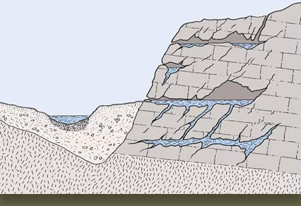
Reljefni oblici u kršu
Površinski krški oblici
Škrape – žljebovi oštrih bridova nastali korozijskim djelovanjem oborinskih vodaVrlo očigledan rezultat nagrizanja karbonatne stijene od strane vode su škrape. One su žljebovi nastali tečenjem kišnice i sniježnice (vode nastale otapanjem snijega) po stijeni. Mogu biti i podzemne škrape.

Kamenice – plitka udubljenja koja nastaju korozijom na uravnjenom vapnencu
Voda može otapati (nagrizati) karbonatnu stijenu i dok stoji na njoj u obliku lokve. Često ovdje još trune lišće što pojačava nagrizanje (koroziju). Taka nastaje kamenica – široko i plitko udubljenje u okršenoj stijeni.

Ponikve ili vrtače – ljevkasta udubljenja na čijem dnu se nalazi plodna crvenica ( kvalitetno, obradivo tlo )
Ponikve su ovalna udubljenja sa strmim stranama, nastala korozivnim djelovanjem poniruće vode u tektonski razlomljenim zonama. Širina i dubina vrtača može iznositi od nekoliko do stotinu metara. Prema dnu se sužavaju i dno im je obično prekriveno crvenicom.

Krška polja i zaravni
Polja su najveći krški oblici. Najčešće su to veće zatvorene depresije unutar krškog terena, dugačke i više kilometara. Nastala su spajanjem rasjeda te bočnim korozivnim djelovanjem vode koja dolazi iz nepropusnih u propusne dijelove tla te nestaje u ponorima. Dulja os polja se obično pruža paralelno pravcima glavnih tektonskih jedinica. Obilježena su rasjedima, zaravnima, kvartarnim i/ili neogenskim sedimentima i naravno u kojima nestaju ponornice. Količina tvari biogenog porijekla u tlu pogoduje brzom bočnom korozijskom djelovanju, a kada otporniji dijelovi zaostaju u obliku kupastih uzvišenja nastaje takozvani kupasti krš.
Razlikuju se tri osnovna tipa polja: rubno (border), strukturno (structural) i temeljno (baselevel).

Podzemni krški oblici
Jame - podzemne šupljine koje su razvijene u okomitom pravcu (45°- 90°)
Jame su otvorenim dijelom u izravnom kontaktu s površinom. Pružaju se pod kutom većim od 45° u podzemlje. Kao vertikalni kanali spuštaju se duboko u stijenski masiv pa predstavljaju najmoćniji kontaktni sustav kroz koji voda prodire u krško podzemlje.
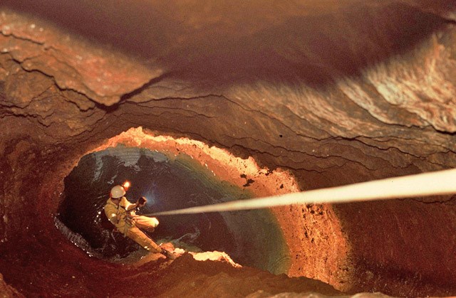
Špilje - podzemne šupljine koje su razvijene u vodoravnom pravcu (do 45° ), bogate su spiljskim ukrasima
Špilje (ili pećine) su također otvorenim dijelom u izravnom kontaktu spojene s površinom, ali se pružaju vodoravno u podzemlje (manje 45°). Vrlo vjerojatno nastaju cirkulacijom vode ispod razine podzemne vode.
Špilje karakteriziraju različite vrste taloga od kojih su najzanimljivije sige, koje su značajne zbog istraživanja klimatskih promjena u geološkoj prošlosti. Upravo sige nastaju procesom suprotnim otapanju, odnosno taloženjem.
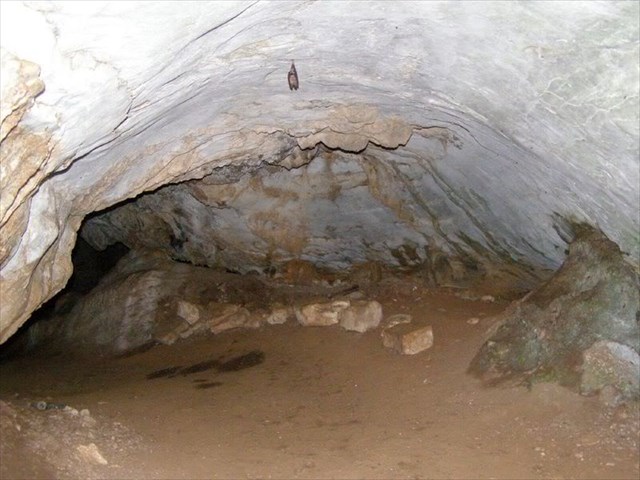
Kaverne – zatvorene šupljine krškog podzemlja
Kaverne su podzemni krški oblici koji nemaju kontakt s površinom, a mogu također biti izuzetno velikih dimenzija. U Hrvatskoj je registrirano preko 850 kaverni (2006).
Da bi mogli logirat Earthcache postavit ću Vam nekoliko pitanja, a Vi mi pošaljite odgovore na mail, ne morate čekat moj odgovor već slobodno logirajte, ako nešto nije u redu kontaktirat ću Vas.
1. Promotrite nagib u Juranskoj peći. Je li ovdje rijeć o špilji ili o jami? Objasnite zašto?
2. Promotrite zidove u Juranskoj peći. Opišite njihov oblik. Na koji površinski krški oblik Vas to podsjeća?
3. Napravite fotografiju sebe (fotografijom na kojima je gps/mobitel, ruka ili noga NE ispunjavate zadatak i log će biti obrisan) ili papira s vašim nikom sa lokacije EC-a te ju stavite u svoj log.
Uživajte u ovom predivnom mjestu!
Izvor:
mr.sc. Marijan Biruš: Krš za neznalice
Marija Klanfar: Podzemni krški oblici
Bukal Nikolina: Završni diplomski rad


Juranska peć befindet sich westlich des Dorfes bei Orič in der Gemeinde Pićan. Ihre äußere Öffnung ist von beeindruckenden Dimensionen. In Juranska peć kann sich Eis befinden der bis spät in den Frühling erhalten bleibt. Im Sommer gibt es eine große Temperaturdifferenz zwischen innen und außen. Sie befindet sich auf dem Karstgebiet.
Was ist Karst?
Karst ist eine Sammlung von Geländeformen , die die Produkte der chemischen Verwitterung (Korrosion) von Gesteinen die im Wasser löslich sind (Karbonate, Gips, Steinsalz ), dh Bereiche von Geländeformen in Karbonatformationen entwickelt sind, die in der Regel von Calcium (CaCO3) und Magnesium (MgCO3) Karbonat bestehen.
Aufgrund einer solchen chemischen Zusammensetzung der Karbonate Felsen werden sie Kalkstein und Dolomit genannt, und ihre in Wasser charakteristisch Löslichkeit ermöglicht die Endstechung von Karst.
Karst ist daher ein allgemeiner Name für eine Reihe von morphologischen, hydrologische und hydrogeologisch Merkmale des Geländes, das ausgebaut ist von Felsen die in Wasser löslich sind.
Die Hauptrolle bei der Bildung von Karst Relief sind chemische Prozesse. Es sind da auch noch tektonischen und mechanischen Prozessen, aber ohne chemische Prozesse würden wir nicht über Karst Relief reden. Karst Relief ist das Ergebnis einer chemischen Verwitterung von Gesteinen. Wichtigste Voraussetzung für den Prozess der Verkarstung ist Löslichkeit der Karbonat Gestein im Wasser. Dieses Gesteine sehen in der Tat sehr stark und widerstandsfähig aus, aber das Wasser erodiert sie. Dieses Ätzen (chemische Verwitterung, Korrosion) geschieht nicht schnell, sondern über viele Jahre.
Aufgrund der Korrosion sind in Karst viele Löcher. Durchlöcherung ist eines der Hauptmerkmale der Felsen von Karstgebiet . So entstehen zahlreichen Höhlen, Dolinen und andere Formen.
Das grundlegende Merkmal des Karst Reliefs ist die selektive Löslichkeit von Felsen im Wasser die Kohlensäure enthält. Diese Löslichkeit passiert nicht gleich, aber im Laufe der Jahre, und die Durchlässigkeit ist nicht wie die der Spongiosa (da Karbonate nicht weich sind), aber durchs Ätzen entstehen Risse aufgrund dem die Felsen nicht mehr das Wasser zurückhalten können.
Aufgrund dessen entsteht ein Relief mit vielen Hügeln und Mulden. Im Allgemeinen werden die Reliefveränderungen von Karbonat Gesteinsmassen auf Oberirdische- und Unterirdischer Karstformen aufgeteilt.
Die Oberirdische Karstformen sind: Karren, Kamenitza, Dolinen, Uvalas und Poljen. Die wichtigsten Unterirdische Karstformen sind: Höhle, Schachthöhlen, Flussschwinde und Kaverne.
Feste Kalziumkarbonat Felsen oder Kalkstein Felsen erscheinen oft auf der Oberfläche als felsiger Boden, und wenn der Kalkstein durch Lehmboden bedeckt ist entwickelt sich der Karst mit verschiedenen Formen der Vegetation.

Karstformen
Obererdische Karstformen
Karren - Rillen mit scharfe Kanten gebildet durch Korrosionsaktivität des Regenwasser. Sehr offensichtlich durch Folge von Korrosion von Karbonatgestein durch Wasser entstehende die Karren. Sie sind Rillen gebildet durch fließt des Regens und Schnees (Schmelzwasser vom Schnee) an dem Felsen. Es können auch untererdische Karren sein.

Kamenitza – flache Vertiefungen entstehen durch Korrosion in einem abgeflacht Kalkstein
Wasser kann (erodieren) die Karbonatfelsen auflösen auch während es in Form von Pfützen stehen. Oft verrotten noch Blätter was die Korrosion (Korrosion) verstärkt. So entsteht Kamenitza - breite und flache Vertiefung in verkarsteten Felsen

Doline – trichterförmig Vertiefungen, an deren Boden sich fruchtbare rot erde befindet (gutes Ackerland )
Dolinen sind ovale Vertiefungen mit steilen Flanken, die durch korrosive Wirkung der intermittierenden Wasser in tektonisch fragmentiert Zonen erstanden sind. Die Breite und Tiefe der Senkgrube kann von wenigen bis zu hunderten von Metern sein. Nach Unten sind sie schmaler und der Boden ist bedeckt mit roter Erde.

Karst Polja
Die Karst Polja sind die größten Karsterscheinungen. Sie sind vor allem tiefe große Depression innerhalb der Karstgebieti im Kilometermaßstab. Sie entstanden Fusion an tektonischen Strukturen durch seitliche Korrosion des Wassers das von undurchlässigen zu porösen Teile des Bodens kommt und verschwindet in den Abgrund. Die längere Achse des Polja gehen in der Regel in parallelen Richtungen der Haupt tektonischen Struktur. Gekennzeichnet sind sie Tektonisch, Plateau, Ebenen, quartären und / oder Neogen Sedimenten und natürlich wo die Flussschwinde verschwinden. Die Menge der Stoffe biogenen Ursprungs im Boden begünstigt die schnelle Seitenkorrosionswirkung, und wenn mehr resistentere Teile hinterherhinken in Form von konischen Hügel, entsteht der sogenannte Kegelkarst .
Es gibt drei grundlegende Arten von Polja: Rand (border), strukturelle (structural) und Grund (baselevel).

Untererdische Karstformen
Schachthöhlen - unterirdische Hohlräume, die in vertikaler Richtung (45 ° - 90 °) entwickelt wurden.
Die Schachthöhle ist offen teilweise in direktem Kontakt mit der Oberfläche. In einem Winkel von mehr als 45 ° unter der Erde. Als vertikale Kanäle tief in den Felsmassiv absteigen, sie darstellen das stärkste Kontaktsystem durch die das Wasser dringt in den Karst Untergrund.

Höhlen - unterirdische Hohlräume, die in horizontaler Richtung entwickelt wurden (bis 45 °), sind reich an Höhlen Verzierungen
Höhlen sind auch mit offenem Teil in direktem Kontakt mit der Oberfläche verbunden, aber gehen horizontal in die Untererde (weniger 45 °). Möglicherweise entstehen sie durch umlauf des Wasser unter dem Niveau der Untererdischen Wassers.
Die Höhlen sind durch verschiedene Arten von Ablagerungen gekennzeichnet, von denen die interessanteste speleothems, die für die Erforschung des Klimawandels in der geologischen Vergangenheit wichtig sind. Sinter das durch eine allmähliche mineralische Ablagerung entsteht insbesondere eine Kalkablagerung.

Caverns - geschlossen Hohlraum Karst
Kavernen sind unterirdische Karstformationen, die keinen Kontakt mit der Oberfläche haben, können auch sehr groß sein. Kroatien hat mehr als 850 Höhlen registriert (2006).
Zum Logen dieses Earthcaches habe ich für Sie ein paar Fragen. Bitte die Antworten auf mein E-mail Adresse schicken. Sie müssen nicht auf meine Antwort warten, sondern können gleich Loggen, wenn was nicht korekt ist werde ich Sie kontaktieren.
1. Betrachten Sie die Neigung in Juranska peć. Ist es eine Höhle oder einer Schachthöhle? Erkläre warum?
2. Betrachten Sie die Wände in Juranska peć. Beschreiben Sie ihre Form. Auf welche Oberflächen Karstform erinnern Euch dass?
3. Mache ein Foto von sich selbst (Foto das ein GPS/Handy, Hand oder Bein zeigt, erfüllen NICHT die Aufgabe und werden gelöscht) oder Papier mit Ihrem Nick an der Lokation des EC und bitte zum Log hohladen
Genießen Sie diesen wunderbaren Ort!


Juranska pec is located west from Jurana village near Oric in Pican municipality. Its entrance is impressive. Ice can be found in Juranska pec, and usually the ice remains till the late in the spring. During the summer there is a large temperature difference between inside and outside. It is located in karst terrain.
What is karst?
Karst is a group of landscape forms that are formed by dissolution (corrosion) of rocks soluble in water (carbonate rocks, gypsum, rock salt), ie. it is the whole spectrum of various landscape forms developed in carbonate formations, usually in calcium carbonate (CaCO3) and magnesium carbonate (MgCO3).
Considering their chemical composition, carbonate rocks are called limestone and dolostone, and their solubility in water allows formation of karst.
Therefore, karst is general term for group of morphological, hydrological and hydrogeological features of terrain that are built from rock soluble in water.
Chemical processes have the main role in karst landscape formation. Tectonics and mechanical processes also have their role in karst formation, but without chemical processes there would be no karst landscape. Karst landscape is a result of chemical weathering of rocks. The most important requirement for karstification process is solubility of carbonate rocks in water. Although those rocks seem hard and sturdy, the water dissolves them. That process of chemical weathering and corrosion is a slow process and it happens over the large periods of time.
Because of corrosion, there is a large number of cavities within karst. Porosity is one of the main characteristics of rocks in karst areas. It also results with numerous caves, pits and other formations.
The main characteristic of karst landscape is selective solubility of rocks in water that contain carbonic acid. This rock solubility is not instant process but it takes large amount of time. Permeability of rocks is not the same as in spongy materials, but cracks are formed with corrosion and rock can’t withhold water anymore.
The result of this process is rugged landscape with numerous hollows and hills. In general, landscape changes in carbonate rocks can be either on the surface or beneath the surface.
The main karst features on the surface are: karrens, sinkholes, kamenitzas, uvalas and poljas. The main underground karst features are caves, pits, ponors and caverns.
Limestone often can be found on the surface in the form of rock soil, and when limestone is covered with clay soil then different forms of vegetation can develop on karst.

Karst Landscape Features
Karst features on the surface
Karrens – grooves with sharp ridges, formed by water corrosion. Obvious results of carbonate rock dissolving are karrens. Karrens are grooves that are formed when rainwater and water from snow melting flow on stone surface. Karrens can also form under the surface.

Kamenitzas – shallow hollows formed by corrosion on flat limestone areas.
Water can dissolve carbonate rock while it stays on the rock as puddle. Leaves often decompose on such locations and it can increase the speed of corrosion. Kamenitzas are formed by this process – wide and shallow hollow in karstic rock.

Sinkholes – funnel-like depressions or holes.
Sinkholes are oval depressions with steep edges, formed by corrosive effect of plunging water in tectonically fragmented areas. The width and depth of sinkholes range from several meters to even hundred meters. They become narrower towards the bottom.

Karst poljas
Poljas are the largest karst features. They are usually closed depressions inside karst area that can be long even several kilometers. They are formed by merging of faults and by side corrosion of water that flow from impermeable to permeable zones and disappears into sinks. Longer axis of polja usually is parallel to the direction of main tectonic units. Poljas are characterized by faults, plateaus, Quaternary and/or Neogene sediments into which underground rivers disappears. The quantity of biogenic material in soil can increase the speed of side corrosion. When more resistant parts remain in the form of conical hills, the so-called cone karst is formed.
There are three different types of polja: border, structural and baselevel.

Underground karst features
Pits - Underground hollow places that are developed in vertical direction (45°- 90°)
Pits have direct contact with the surface with their opening. The angle of their extension towards underground is larger than 45°. As vertical channels they descend deeply into rock massif, and they represent contact system through which water penetrates into karst underground.

Caves – underground hollow places with horizontal direction (up to 45°), they are rich with cave formations.
Caves also have direct contact with the surface with their opening, but they extend horizontally into underground (less than 45°). They form when water circulate bellow level of groundwater.
Caves are characterized by different types of deposits, the most popular of them are dripstones. Dripstones are important for their role in researches of climate changes in geological history. Dripstones are formed by process that is opposite to melting, ie. by precipitation.

Caverns – closed hollow places in the karst underground.
Caverns are underground karst formations that don’t have contact with the surface, and they also can be of very large dimensions. There are more than 850 registered caverns in Croatia (2006).
In order to log this EarthCache I will ask you several questions and you should send your answers to my e-mail. You don’t have to wait for my confirmation, feel free to log the find as son as you send your answers. If there are problems with your answers, I will contact you.
1. Observe the slope in Juranska pec. Is Juranska pec a cave or a pit? Explain why?
2. Observe the walls in Juranska pec. Describe their shape. On what karst feature that can be usually found on the surface does it remind you of?
3. Make a photo of yourself (photo showing a GPS/mobile phone, hand or leg do NOT fulfill the task and the log will be deleted) or paper with your nick from the location of the EC and put it to the log.
Enjoy this beautiful location!
Izvor:
mr.sc. Marijan Biruš: Krš za neznalice
Marija Klanfar: Podzemni krški oblici
Bukal Nikolina: Završni diplomski rad
Veliko hvala GC Edo na pomoći, podršći i savjetima!
Souvenir/Banner:
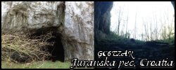
Code: <a href="http://coord.info/GC6EZAR" ><img src="https://s3.amazonaws.com/gs-geo-images/3b5a1bb8-a396-49a1-b824-a7e405695c8c_l.png" /></a>
