The Garlock Fault is the second largest fault zone in California, behind the San Andreas Fault. It begins in the Tejon Pass and travels north east for about 300 miles. Below the Garlock Fault is highlighted in red.

What is really interesting here is how these mountains came to be. Everyone knows about the San Andreas Fault and how it's famous, but what many people don't realize is that the Tejon Pass the junction of California's largest fault lines. The actual intersection of the Garlock and San Andreas Faults is about 2 miles south west of here, about a half a mile north of Frazier Mountain High School.
Before I go into any more details lets first discuss the basic fundamentals of how fault lines are created and now they work. The answer can be found in your kitchen, literally. When boiling pasta on the stove, the hotter pasta floats to the surface then when it cools it sinks. This effect has a name. Convection currents in your pot at home and in the earth are nearly identical. There are a few difference though. One is with water, rather than boiling rocks and the other is that one is less a few inches while one is miles deep. Convection currents are continues cycles in the earth's mantel that make hotter rock rise, and cooler rock fall and the cycle begins over and over again. When this happens, it causes fractures in the earth's crust. When fractures occur, a fault line is created.
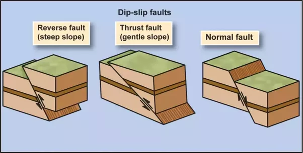
At this site you can observe something special along the Garlock Fault. Sometimes, or actually most of the time, the fault isn't just a strait line down the crust. It's jagged and at an angle. There are two types of these transverse (strike-strip) faults. One is called normal and the other is called reverse or thrust. The way to tell the difference is to see where the hangwall and footwall are in relation to each other. If the footwall is higher than the hangwall, then it's a reverse transverse fault. If the hangwall is higher than the footwall, than it's a normal transverse fault. Refer to the chart below that can give you a better sense of what to look for.
The Garlock Fault is a left lateral fault. This means, if you are on one side of the fault, looking at the other, the other side would move to the left relative to you. One of the reasons why there are large mountains here is because the Garlock Fault and the San Andreas fault are opposite lateral faults. Meaning, the San Andreas is a right-latteral fault and the Garlock is a left lateral fault. This mixture of uneven faults creates large valleys on one side (The Mojave Desert) and large mountains on the other (San Emigdio Mountains).
Works Cited
http://www.decodedscience.org/hoodoos-desert-formations-help-understand-seismic-hazard/25297/2
http://pubs.usgs.gov/gip/earthq3/safaultgip.html
TO LOG A FIND ON THIS CACHE YOU MUST GIVE ME THE CORECT ANSWERS BEFORE YOU LOG A FIND. YOU CAN CONTACT ME THROUGH MY EMAIL OR THE GEOCACHING MESSAGE CENTER. ANY INCORRECT ANSWERS WILL RESULT IN A DELETED LOG
1. Garlock Fault - Tejon Pass on the first line of your email.
2. Look at the hillside in front of you. Using the strike slip chart above, what would this section of the fault be considered as (normal, reverse, or strike-strip) AND your reasoning behind your conclusion. HINT: Think about how erosion would effect these different types of fault after a major slip.
3. Describe two geologic differences can you see from the bottom of the hill to the north side of the hill.
4. Using your answers in the question above to help you, about how far up on the hill does the Garlock fault exist?
* NOTE - You will likely not receive an email back from me, unless I need clarification on your answers. Please, don't wait for me to tell you you have it correct or not. I do review your emails within 12 hours of getting them in my inbox and with other of my earthcaches, it has become too hard to do. As soon as you send the email, you can log this earthcache.