Localization
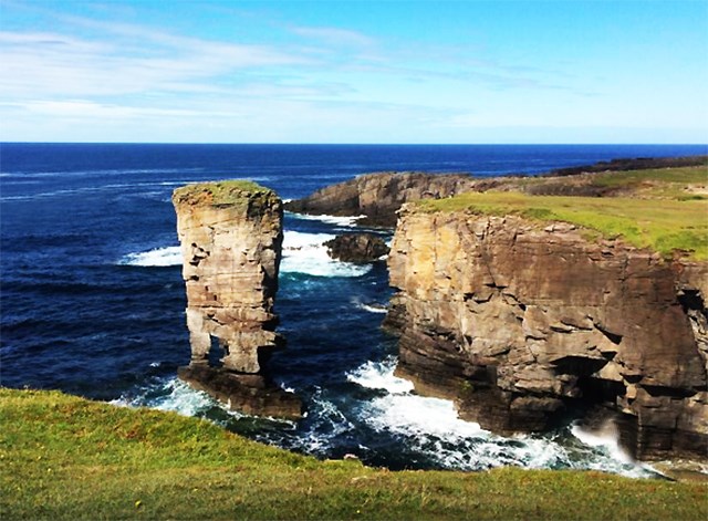
Yesnaby is an area in Sandwick, on the west coast of Orkney Mainland, Scotland, south of Skara Brae. It is renowned for its spectacular Old Red Sandstone coastal cliff scenery which includes sea stacks, blowholes, geos and frequently boiling seas. A car park, coastal trail and interpretive panels serve visitors. The car park is an old army base with concrete former gun mounts.
CASTLE OF YESNABY
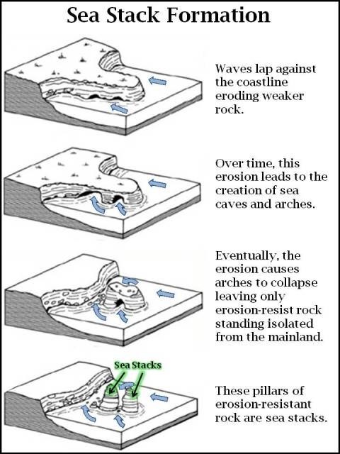
Coastal headlands commonly erode at varying rates, leading to very unusual and striking rock formations.
A stack or sea stack is a geological landform consisting of a steep and often vertical column or columns of rock in the sea near a coast, formed by wave erosion. Stacks are formed over time by wind and water, processes of coastal geomorphology. They are formed when part of a headland is eroded by hydraulic action, which is the force of the sea or water crashing against the rock. The force of the water weakens cracks in the headland, causing them to later collapse, forming free-standing stacks and even a small island. Without the constant presence of water, stacks also form when a natural arch collapses under gravity, due to sub-aerial processes like wind erosion. Stacks can provide important nesting locations for seabirds, and many are popular for rock climbing. All this is also true for the Castle of Yesnaby.
Local Geology
The coastal cliffs are formed from the Lower Devonian sandstones ascribed to the Yesnaby Sandstone Group - a set of geological formations restricted to the Yesnaby area, and to the overlying beds of the Lower Stromness Flagstones. There is some doubt as to the age of these beds and they may be Mid rather than Early Devonian. And No paleontological confirmation of the age of the Yesnaby sequence is available but the Yesnaby Sandstone could be late Emsian early Eifelian.
On Orkney, the Yesnaby Sandstone Group forms spectacular cliff outcrops some 7 km NW of Stromness. To the south of the Garthna Geo Fault wich is intruded by a later dyke, the Harra Ebb Formation can be seen banked against a palace-hillside of Moine basement which forms the modern cliff. Up to 100m of sandstone and siltstone are present with tongues of breccia. Deposition was from current flowing down the hillside and out onto a flatter plain.
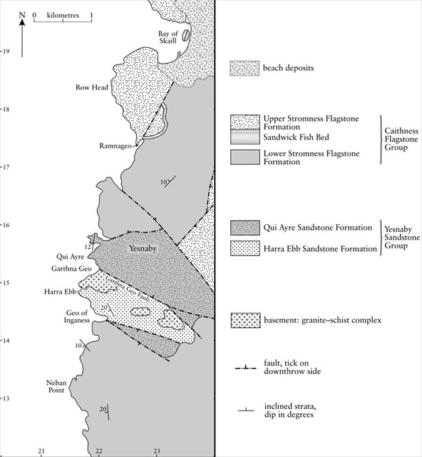
Cliffs at Yesnaby to the north of the Garthna Geo Fault display a superb sequence of Aeolian sandstones with large scale cross-bedding indicating wind direction.
how to determine the wind direction during deposition by examining the shape of the cross beds
The Aeolian sandstone pass up into waterlain sandstones with occasional pebbes, desiccation cracks and ripples. It appears that the top of the dune sequence was reworked by fluvial or lake-margin processes. The top of this sequence is marked by a 10° angular discordance with a pebble lag beneath the Middle ORS but there is little evidence for a major unconformity.
A borehole at Warbeth, 2 km west of Stromness encountered 50 m of purple siltstone and fine grained sandstone beneath the sub-Middle ORS unconformity and overlaying 11 m of breccia resting on metamorphic basement. This fine-grained development resembles part of the Lower ORS of Caithness. Mykura(1976) suggests that there were strong local facies changes in the Lower ORS of the aera related to the topographie of the basement surface.
Your tasks to log this earthcache :
- Observe the cliffs from the parking to the castle of Yesnaby : Where can you see conglomerate ? (near the base, on the middle, or near the top ?)
- what is the predominant color of these cliffs and what is it due ?
- Which 2 elements were mainly responsible for the development of the Castle of Yesnaby ?
- Cliffs faces in the vicinity display superb sequence of Aeolian sandstones with large scale cross-bedding, indicating wind direction. Observe it and try to indicate what was the wind direction ?
- Although this is not a requirement for logging the cache, please add a photo of yourself and/or gps at the viewpoint. (Optional)
Reminder concerning "Earthcaches" :
There is no container to search or to find. Simply visit the site, read the description, observe and understand in order to answer the questions above. Log your "Found it" and at the same time, send me your answers by email or by the Message Center. In case of problem, I will contact you. And thank you for not including responses in your logs !
The above information were compiled from the following sources:
- The Geology of Scotland 4th edition (N.H.TREWIN) Published by The Geological Society London.
- Wikipedia, the free encyclopedia.
- Earthwise British Geological Survey