
The Derwent Dam is famous as 617 Squadron used it for practising their technique for the 'Dam Busters' raid, due to its similarity to the German dams. Here a Lancaster Bomber is pictured flying over the dam during the 65th anniversary.
This earthcache will explain the less famous geology.
Photograph by Greg Smith Photography.
The Valley Before the Reservoirs
The physical character of the Upper Derwent Valley is strongly influenced by areas to either side of the river: the Millstone Grit and the underlying shale-dominated beds. The sediments that formed the Millstone Grit were laid down in the Middle Carboniferous period by a series of rivers flowing from the north creating large river deltas. These rivers deposited a cyclic succession of shales, siltstones, and cross-bedded sandstone. The upstanding, higher ground is formed from gritstone, while the valleys and other lower lying areas are cut into softer shales. The higher ground to the side of the Upper Derwent Valley includes the gritstone edges such the Derwent Tors, already covered by a series of earthcaches.
But what about the Upper Derwent Valley itself? We do know that the Peak District was covered by ice during at least one of the ice ages of the last 2 million years (probably the Anglian glaciation of around 450,000 years ago) as evidenced by the patches of glacial till or boulder clay that can be found across the area. It was not covered by ice during the last glacial period, which peaked around 20,000–22,000 years ago.
There are several types of valley commonly found -
- Glaciers cut distinctive U-shaped valleys with a flat floor and steep sides. The glacier widens, steepens, deepens and smoothes existing V-shaped river valleys.
- Rivers form V-shaped valleys. Rivers begin high up in the mountains and they flow quickly downhill eroding the landscape vertically. As the river erodes downwards the sides of the valley rocks loosen and fall. The rocks which have fallen into the river help the process of corrasion and this leads to further erosion. The river transports the rocks downstream and the channel becomes wider and deeper creating a V-shaped valley between interlocking spurs.
- A meltwater valley - this is a type of glacial valley but it is formed by the melting waters of the glacier, rather than carved by the glacier itself. These could include a tunnel valley, which is a large, long, U-shaped valley originally cut under the glacial ice near the margin of ice sheets. There are also urstromtal valleys, which are formed by meltwaters that flowed more or less parallel to the ice margin.
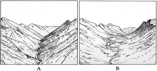
Diagram A shows a V-shaped valley. Diagram B shows a U-shaped valley
Plans for Building New Reservoirs
The Upper Derwent and Ashop valleys had attracted the interest of the growing industrial cities of Derby, Leicester, Nottingham and Sheffield, due to their narrowness and high rainfall.Each city had drawn up separate plans for damming the River Derwent, which were compounded by declarations of interest in a share of the water by the county authorities of Derbyshire, Leicestershire and Nottinghamshire. Eventually, a Parliamentary Committee decreed that only a joint bill incorporating claims of the three cities plus Nottingham and Derbyshire would be acceptable and the Derwent Valley Water Board was the result.
At the time, this was largest attempt in Britain to provide a combined water supply. New Derwent Valley Water Acts were passed in 1901 and 1904, which allowed for the phased construction of six dams beginning with three at Derwent, Howden and Ronksley. It was estimated that these first three reservoirs would provide 590,980 hectolitres of water per day. The chief engineer employed on the project was Edward Sandeman, who had experience of building masonry dams elsewhere in England. When Sandeman considered the geology and topography he decided to alter the plans to hold the same volume of water behind only two dams, covering 4.5km of valley bottom, and with Derwent Dam raising 7 metres to 34 metres tall. The proposed Ronksley dam was cancelled and construction of Howden and Derwent dams began in July 1901 and February 1902.
Building the Derwent Dam
The most common type of dam is earth construction, this dam type is constructed as a simple embankment of well compacted earth. Variations on this may include rocks or concrete filling the earth. This is not the type of construction used here, which is what makes the Derwent Dam special.

The Derwent Dam
Both the Derwent and Howden Dams are similarly constructed of masonry – in fact huge Millstone Grit blocks. Millstone Grit is the most famous type of rock of the Dark Peak, and is therefore very much at home being displayed on these spectacular dams. Undressed blocks were set in concrete without touching each other to create the cores of the dams. Roughly squared uncoursed stones were used for both the downstream and upstream faces below ground level, and dressed coursed stone used for the faces above ground. The upstream faces are vertical, while the downstream ones slope with a slight concave curve.
Two towers were incorporated into the construction, rising above the tops of the dams. They are finished with ‘Victorian Gothic’ architectural embellishments including crenellations, arched windows and buttresses. Pipes in both towers allow emptying of the reservoirs, and sluices situated in the east tower of Derwent dam lead to 6 aqueducts which supply water to filters at Bamford and Yorkshire Bridge, and the Rivelin Tunnel. The west tower of Derwent dam also contains a plumb line of fine steel wire to measure movement of the structure. Cableways suspended from cable towers erected on platforms on both valley sides were used in the construction of both dams.
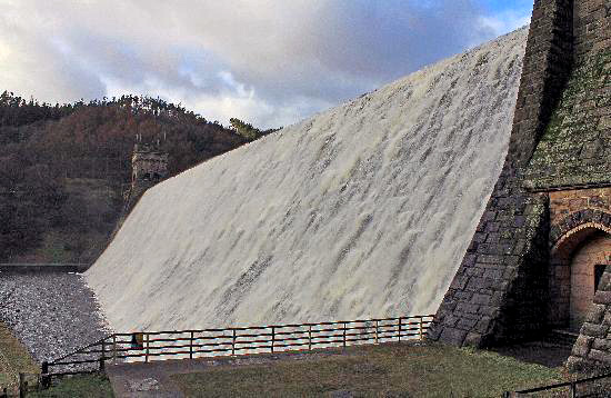
The Derwent Dam is designed to overflow when it reaches maximum capacity
At maximum capacity the levels of both reservoirs are regulated by allowing water to spill over the tops of the dams between the towers. This again is a relatively unusual sight, as side channels are so often built for the purpose of overflow. In the case of the dams here, the water simply cascades down the dam in what can be a spectacular display.
Geological Problems during Construction
During construction work, geological flaws were discovered in the underlying bedrock that would have allowed water to seep under and around the dams. This was overcome by the excavation of deep, narrow trenches into the rock below and to the sides of each dam until solid watertight rock was reached. These trenches were filled with stone and concrete and reached a depth of approximately 35m below the original ground surface. The dam is 34 metres high so you can imagine that a barrier has been created effectively of the same size going underground into the earth. This caused great delays in the construction and gave the engineers some headaches.
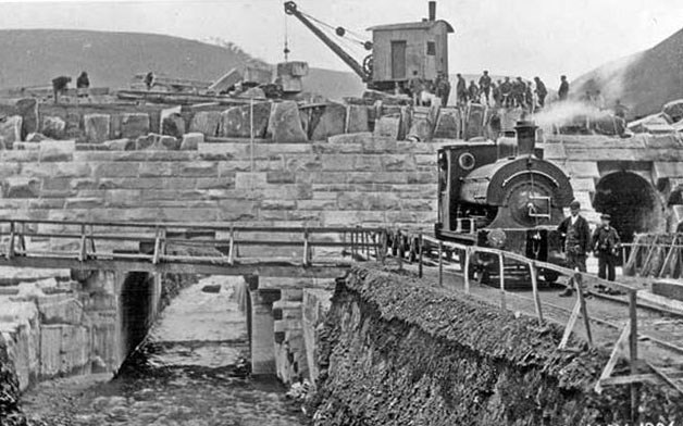
The dam pictured during construction
Stone-laying ceremonies were carried out at both dams on the 21st June 1907. Large Millstone Grit record stones were placed over the doorways of the dams’ west towers bearing identical inscriptions except for the name of the reservoir. Howden dam was officially opened on the 5th September 1912 with great ceremony by Edward Fraser, the new chairman of the DVWB, after King George V had declined the invitation to perform the cermony. Over 2,000 people were present including officials, invited guests, workmen and families. The date 1912 was later added to the record stone. In contrast, the opening of the Derwent Dam here was undertaken without any of the above ceremony, was not minuted, and the record stone did not have the year 1916 added. It has been suggested this lack of formality may have been because of the First World War, and also the relief at overcoming engineering problems.
How local is the stone - where did it come from?
Ladybower Gorge had originally been targeted as the stone source but public protests forced this plan to be abandoned and a site at Bole Hill, Grindleford, was bought instead. This is about 10 miles south down the Derwent Valley, and therefore the construction of a railway to transport stone into the valley was required.
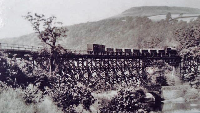
A railway was constructed to transport the stone up the Derwent Valley
The beds of millstone grit were near to the surface at an average depth of some 65 feet. The quarry face was 1,200 yards long and it was estimated that it contained some 2.4 million tons of top grade building stone. The silica and feldspar composition of the millstone grit at Bole Hill had the advantage of hardening after weathering. So much so that the masons found some of the stone that had already been exposed to the atmosphere was exceedingly hard and more laborious to work than the freshly quarried stone. It was the perfect material from which to construct the Howden and Derwent Dams.
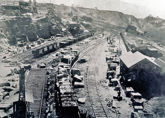 Bolehill Quarry in it's heyday
Steam traction engines brought in the heavy plant and equipment to lay a standard gauge railway in the quarry face, which was then linked by an incline to the Midland Railway Hope Valley Line, almost 400 feet lower down the valley. During its seven and a half years life the quarry produced over 1.25 million tons of stone. Sheds to house the workshops for dressing the large blocks, weighing between 20 to 30 tons each, were sited adjacent to the quarry face. Rubble and filler stone was loaded by two steam-powered cranes straight into specially built trucks, these were then lowered down the 300 foot incline, with its 1 in 3 gradient, in hazardous operation controlled by a brakeman on the drum of the winding wheel. The stone housings of the wheelhouse can be found at the top of the now overgrown incline, the steepness of which can be appreciated by ascending the remaining section.
The quarry at Bole Hill must have been like an anthill of frenzied workers. In October 1905 some 439 men were employed there, operating two 12-ton cranes, nine 7-ton cranes, one 5-ton crane, three locomotives, the winding drum and almost 100 tipper wagons. Two men were killed whilst working in the quarry; one fell from a bench of rock and died from concussion, the other fatality occurred in an accident in a cutting when three loaded trucks broke lose and ran into an area where around 20 men were working.
At the end of December 1910 production ceased, although some small quantities of stone continued to be sent up to Derwent up to April 1914. The start of 1911 saw much of the plant removed from the site and later in the year a plan was considered to construct a housing estate in the quarry workings. Thankfully this did not come to fruition, just in case of any further developments in the Upper Derwent Valley. This is just as well, as the site is part of a very popular and scenic tourist estate today.
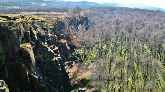 Bolehill Quarry today
There were future developments in 1935, with the construction of the Ladybower Reservoir, but this was to be mainly an earth dam and not so much stone would be required. So Bole Hill was finally closed in September 1914, when all the plant and materials had been removed. It proved a blessing that the site was never re-opened, the old quarry became something of a liability to the D.V.W.B., who made a gift of it to the National Trust in 1947.
It is a fascinating place to explore, where you can trace the complex of abandoned quarry faces and spoil heaps, the former incline is well defined and there are ruins of the old powder magazine and winding drum housing. Nature is in control here now and the busy wood ants are the most active workers on Bole Hill. The tremendous dam walls at Howden and Derwent stand firm as a testimony to the skill and hard work of the quarrymen of Bole Hill. At the time of publication, a National Trust cache was located in Bolehill Quarry - visit cache page.
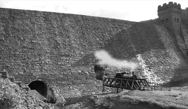
An interesting photograph showing a railway engine at the dam during construction
Questions to Answer
In front of you is the huge Derwent Dam. Please examine the stone you see here, and the text on this page, and then send me your answers. Ideally this will be via the email service rather than the messenger. Please send the answers before you log your find, or soon after. If no answers are received, your log will have to be deleted to comply with the guidelines.
Question 1)
At the start of the listing, I explained about different valley types. Please observe the valley in which you are standing, and try to account for the effect man might have had on the valley. Do you believe this valley is –
- a U-shaped valley (formed directly by a glacier)
- a V-shaped valley (formed entirely by the river Derwent)
- a meltwater valley, formed by melting water from a glacial
Question 2)
Now turn your attention to the stone. This dam has stood here for a hundred years. The water regularly flows over the dam in the winter, between the two towers. I have explained about the type of millstone grit used here and the properties of why it was chosen. It is a type of sandstone and therefore is theoretically subject to weathering and erosion from the elements.
Examine the stone on the main dam wall between the towers (where the water would flow) and also examine the stone on the towers and the side dam walls, and explain whether you believe the water flowing down the dam is affecting the stone. Can you perhaps see sharp edges smoothed off, or does the stone look smoother between the towers than on the sides? You should still be able to make these observations when the water is flowing, but you will need to walk close to the dam. Why do you think you are seeing what you see, and how will that affect the dam in the long term?
Question 3)
Walk to the base of the east tower (the west tower is not accessible). Please describe the texture of the rock. Please estimate the angle of the dam from here (try to be as accurate as possible). You can also see the stones in 3 dimensions from here, please estimate the dimensions of the largest millstone grit block you can see from here.
Optional Task 4)
A photograph of yourself / GPSr would be good additional proof of your visit, and would be appreciated if at all possible.
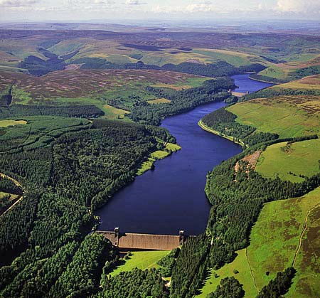
An aerial view of the Derwent Dam and Reservoir
Please enjoy your visit to the Derwent Dam.