Welcome to Kildare Tip Top
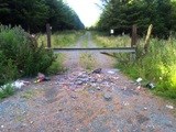
This cache is so named because the starting coordinates resemble a TIP. And despite all the litter and squalor cause by fly-tipping, once you leave it behind, there is a surprisingly beautiful view over the plains of Kildare from the TOP - you will come to a Trig Point which marks the summit of Cupidstown Hill - Kildare's highest point - a lofty 379m. If you are trying to visit Ireland's 26 county summits (I know there are 32 counties, but some have shared high points, eh?)- this is a nice easy one!
 |
 |
| Tip |
Top |
The starting coordinates are also your parking waypoint. You are right at the border of Wicklow and Kildare - and as it happens also 1940m from the border with Dublin. As you have found your way to the starting coordinates using your GPS, you can now put it away - the rest of your journey will be guided by the below instructions.
The History of Cupidstown Hill
This game is not all about the numbers despite what some people may think, so here's a little history! And there's no micro on a galvanised industrial estate fence either, sorry! There's is a nice view - and that's why I'm bringing you here!
Little is truly known about the history of this hill or the place name, but Paul Clement's popular book on Irish hillwalking 'The Height of Nonsense' tells a story of a local man who held that the local folklore was that the hill got its unusual name from the area's associations with Oliver Cromwell, who apparently sacked nearby Kilteel. There is a Cromwellstown Hill adjacent to Cupidstown Hill, where, so the story goes, he apparently had his high command post.
His gun at the time had the pet name 'Cupid', from which Kildare's highest hill took its name according to the (unverified) story!
Letterbox Instructions
The final container contains a small stamp - this is not a trading item, so please do not remove it!
Walk 380m NNW along the track from the starting coords. As the track starts to curve around - pause and enjoy the silence and take in a rather nice view of the three sisters - Seahan, Seefingan and Seefin - and Butter Mountain is nestling down at the bottom too.
Your walk continues along the track swinging in a north-westerly direction. When you come to the fork in the path, keep left and head for the gate that is in the middle ground.To the left of the gate, notice a small sign that has a three digit code number Starting "WW". Note this number and continue through the gate. When you come to the rocks, you will be at a mobile phone station - keep away from this and heed all warning signs - this cache does not require you to enter or touch the engineering installation - be wise and steer clear!
Instead, pass to the right of the station and follow the path until you meet the fence. At the time of placement, the fence was in a state of disrepair and it was possible to pass 'through' the fence; however, as and when this fence is repaired, please observe the Leave No Trace principles and pass to the other side in a manner that will not cause it any damage - this may mean walking outside the perimeter.
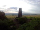
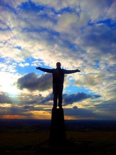
And right in front of you is the Cupidstown Trig Point - you are now the highest person in Kildare! You might take some photographic inspiration from a cache in Rio.
From here you are a short crawl from the cache... turn around and go back in to the ditch you just crossed and the cache is Southwest of you... remember the 3-digit number outside at the gate? Multiply it by 15 and that's the number of meters away the cache is... however - you need to pass the cache and climb the bank to the higher level - on the East side - to start your search!
There's a small FTF prize in the cache. Happy hunting!
Leave No Trace
|
|
The cache has been placed in accordance with the "Leave No Trace" principles.
Please respect these principles when searching for the cache. The cache location is in woodland under management by Coilte.
|