
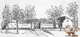
Projekt TWIERDZA KOŁOBRZEG to 12 skrytek usytuowanych na trasie Miejskiego Szlaku Fortfikacji (ok. 12 km długości). W celu znalezienia finałowego kesza , należy odszukać 10 skrytek. Osiem z nich zawiera cyfry potrzebne dla określenia współrzędnych, a dwie klucze niezbędne do określenia lokalizacji skrytki Fort Wilczy. Dlatego nieodzowne jest spisanie danych z dziesięciu z nich. Jedna skrytka nie posiada żadnych infomacji. Wszystkie kesze oznaczone są numerami wyznaczającymi najdogodniejszą trasę poszukiwań. Stąd też #1 przy oznaczeniu Parku Dąbrowskiego. Miłej zabawy!
UWAGA! Współrzedne Fortu Wilczego wskazują katakumby - pozostałości dawnej budowli fortu, nie pojemnik z logbookiem!
N 54° 1(X).(X)(X)(X)
E 015° 3(Y).(Y)(Y)(Y)
Wojna napoleońska w 1807 roku zmusiła do ufortyfikowania wschodniego przedpola twierdzy. Fort Wilczy (Wolfsberg) miał bronić dostępu do portu właśnie od wschodu. Budowano go jeszcze w czasie, gdy Francuzi podchodzili pod Kołobrzeg. Projekt fortu zakładał realizację inwestycji na planie czteroramiennej gwiazdy. Ramiona jej miały mieć formę blokhauzów, gdzie każdy wyposażony miał być w trzy armaty. Maksymalna obsada fortu wynosiła 200 żołnierzy i 9 armat.
Z racji tego, że czas naglił, fort otrzymał formę lunety, czyli dzieła otwartego od tyłu. Szaniec otoczony był trzymetrowym wałem oraz suchym rowem z palisadą. Rów liczył 2,5 metra głębokości i 7 metrów szerokości. Oprócz tego fort otoczony był jeszcze trzema rzędami wilczych dołów. Pierwsze ataki na Fort Wilczy obyły się 7 i 18 maja 1807 roku. Po raz pierwszy został zdobyty przez płk. Sokołowskiego, ale nie udało się stronie francuskiej utrzymać.
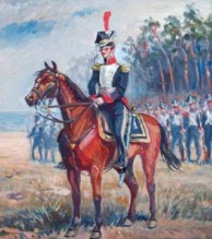
Potem fort w zaciętych walkach przechodził z rąk do rąk. Podczas walk oby dwie strony oskarżały się o łamanie praw wojny. Po pruskiej stronie najbardziej wyróżnił się batalion grenadierów, a po drugiej stronie pułk polski. W raporcie gen. Loison napisał: „Stanąłem na czele grenadierów i Polaków, aby pójść na fort. Grenadierzy zawahali się, ale dzielni Polacy dali im przykład i fort został odzyskany. To odzyskanie fortu zawdzięczamy artylerii i brawurze Polaków". W 1925 roku, fort został zamieniony na amfiteatr. Do jego budowy wykorzystano elementy militarne fortu (ściana frontowa). Do naszych czasów, od strony fosy w Parku Fredry, zachowały się kazamaty tego fortu z widocznym wejściem. W 1945 przekształcono go na silny punkt obrony (należał do 2 linii obronnej). Fort Wilczy został zdobyty przez żołnierzy 12 pp. Polacy zdobyli ten fort po raz trzeci w historii. Po wojnie, do połowy lat pięćdziesiątych fort - amfiteatr był niedostępny - znajdował się na terenach wojskowych. W 1967 roku w Połczynie Zdroju odbył się Festiwal Muzyki i Piosenki Żołnierskiej. W listopadzie tego roku, zapadła decyzja o przeniesieniu tej imprezy do Kołobrzegu. Po rekonstrukcji amfiteatru tu właśnie aż do odbywał się do 1987 roku.

The project FORTRESS KOŁOBRZEG is 12 caches located on the route of Municipal Fortification Trail( approx. 12 km long ) . In order to find the final cache , you must find 10 caches . Eight of them contain the numbers needed to determine the coordinates and in two of themthere are keys necessary to determine the location of the cache Fort Wilczy (Wolfsberg) . Therefore, it is essential to write down data from ten of them. One cache does not have any information. All caches are numbered defining the most convenient route of cache search. Hence the Dabrowski Park is labeled as #1. So have fun !
ATTENTION! The Fort Wolf coordinates indicate the catacombs - the remains of the old buildings of the fort, not a container with a logbook!
N 54° 1(X).(X)(X)(X)
E 015° 3(Y).(Y)(Y)(Y)
The Napoleonic war in 1807 forced to fortify the eastern foreland of the fortress. Fort Wolf (Wolfsberg) had to defend access to port just to the east. It was built even at a time when the French came up in Kolobrzeg.
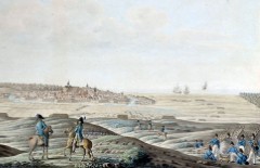
The project envisaged investments fort on the set four-star. Its shoulders were to take the form of blockhouses, where everyone was supposed to be equipped with three cannons. The maximum density of the fort was 200 soldiers and 9 cannons. Due to the fact that the time was pressing, the fort was the form of the telescope, which is open work backwards. Lair was surrounded by a three meter shaft and a dry ditch of a stockade. Trench counted 2.5 meters deep and 7 meters wide. In addition, the fort was still surrounded by three rows of wolf pits. The first attack on Fort Wolf agreements reached on 7 and 18 May 1807 year. It was first conquered by the col. Sokolowski, but failed to keep the French side. Then the fort in fierce battles against passed from hand to hand. During the fighting, the two sides may be accused of violating the laws of war. After the Prussian side of the most distinguished himself Battalion Grenadier and on the other side of the Polish regiment. The report gen. Loison wrote: "I stood at the head of grenadiers and Poles to go to the fort. Grenadiers hesitated, but brave Poles gave them an example, and the fort was recovered. This recovery is due artillery fort and bravery of Poles ". In 1925, the fort was converted into an amphitheater.
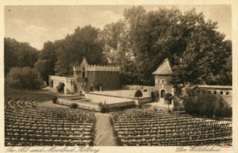
For its construction were used elements of the military fort (front wall). Until our times, from the moat in the Park Fredro, preserved casemates of the fort with a prominent entrance. In 1945 it was transformed into a strong point defense (2 belonged to the defense line). Wolf fort was captured by the soldiers of 12 percentage points. Poles won this fort for the third time in history. After the war, until the mid-fifties fort - amphitheater was available - was in the military area. In 1967, in Połczyn Zdroj Music Festival was held and Song Soldier. In November this year, a decision was made to relocate the event to Kolobrzeg. After the reconstruction of the amphitheater here just to take place until 1987.
You can check your answers for this puzzle on GeoChecker.com.