Karura Forest #36: Ruaka River Swamp

The cache, a small white flip-top plastic pot, is hidden under a small rock at the corner where the two parts of the wooden bench meet, overlooking this verdant swamp area on the eastern side of the forest. If you listen, you may well hear the sound of this bird, as you will throughout most of the forest.
To reach the cache location:
Enter the forest via Gate C (Kiambu Rd) (S 01 14.395 E 36 50.643): after paying your entry fee and parking nearby, head north down the track parallel to the road and then follow it down and swinging left to S 01 14.186 E 36 50.560 where you will find a small track heading south-west and down towards the swamp viewing platform which was constructed using locally harvested eucalyptus in June 2014. The cache is located some 40m beyond this on the western edge of the cleared area.
See GC4PD3V Karura Forest #1 for background information on the forest, including features, access, maps and useful links. See here for a map with gates, trail names and junction numbers
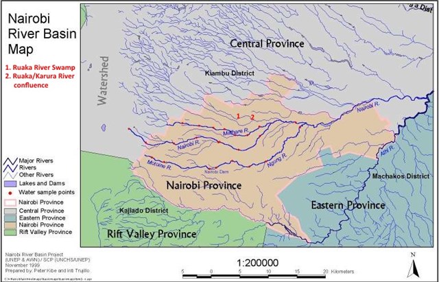
The Rui Ruaka river, which flows through this swamp, is one of the several small rivers draining the Nairobi basin, flowing south-east from its source in the Limuru highlands before passing through the northern part of Karura Forest to join with the Karura River at Thika Highway. 5km east it joins the main Nairobi River, which is joined by the Ngong River (5km), Kamiti River (10km) and Ruiri River (10km) before flowing into the Athi River after a further 4km.
The Athi (second biggest river in Kenya after the Tana) eventually becomes the Galana and enters the Indian Ocean just north of Malindi. See a guide to nairobi rivers and streams for more information, with a map and photos. See also here for a presentation on restoration and rehabilitation of Nairobi river basin.
The map below, showing the location of the Rui Ruaka river swamp in relation to this river system, illustrates that Nairobi sits on a drainage basin between highlands in northwest to the city and plains between east of it. These rivers converge into Nairobi River, itself a tributary of Athi River eventually reaching the Indian Ocean. Nairobi’s rivers and streams divide the city since main roads are generally aligned along them in roughly east-west orientation, while only few roads cross these rivers. This not only divides the city but also contributes to the heavily congested traffic.
