Tahunanui Beach is a Nelson icon! Anyone who lives here, and most that visit, will have some special memories associated with it. However it has changed a lot over time and unfortunately is destined to continue to do so as beaches do not stay in one place forever due to the sand always shifting around.

Waves combined with tides and wind are important elements in making a beach. The higher the waves and the greater angle at which they strike a beach, the larger the volume of sand carried. During storms, waves move sand offshore and flatten the beach. Shorelines mostly retreat in jumps that correspond to each storm. After each storm, sand builds up again, though the recovery is a lot more gradual than the erosion that occurred.
The movement of the sand in this part of Tasman Bay is mostly west to east with longshore drift carrying it from as far as Motueka and dragging it along Rabbit Island. The remainder has come from Nelson Haven and an eroding slump in the Tahunanui hillside. The majority of sand moving around Tasman Bay eventually ends up to the south of the Waimea Estuary. The amount is increasing as the erosion of Tahunanui Beach is being repositioned.
Traditionally Māori used the area to collect seafood. Artefacts, dating from about 1360, indicate it was used as a location to make fishing gear and stone implements.
When the European settlers arrived in Nelson, the area now called Tahuna Sands Reserve wasn’t a beach but the main channel of the Waimea Inlet draining through what is now the Beach Cafe and carpark. At that time, during low tide, Rabbit Island’s intertidal sandbank reached right across to the western end of the present Tahuna Beach. In 1853, after a series of storms, the Waimea Estuary started to drain around the western end of Rabbit Island at Mapua. In addition, a new channel broke through the eastern sandbank in the mid 1870’s - forming Blind Channel and the original Waimea channel started to silt up due to no longer being subjected to the scouring effect of the tides. As a result of these two occurances the present area of Tahuna Sands Reserve (the beach and playing fields) was formed by the end of 1890. However, this was still an intertidal sandbank completely covered by water at high tide.
An important sideline here is that “The Sands” had become a very popular picnic spot but was situated on privately owned land. At the end of 1899 the Nelson City Council signed an Agreement for Sale and Purchase of the land with the owners. A First Schedule included the land to the High Water Mark as shown in the Crown Grant of the 1850's, while the Second Schedule showed the land that had accrued by gradual accretion in the fifty years following. Apparently, under the law, if you owned land to High Water Mark, any land that built up by accretion gradually and actually abutted on your land, belonged to you. In this way - The Sands - was increased by approximately 150 acres, mostly sandhills and mudflats, but worth thousands of pounds to Nelson today. The price paid was 300 pounds so that council had huge foresight of which we all should be very grateful.
Tahunanui Beach has not always been a sand beach. Surprisingly in the 1800’s it was covered in gravel. As a result of the new channel breaking through the eastern Rabbit Island sandbank (as above) the sand from the tip eventually washed around to form the existing front and back sand beaches. This was assisted by the seawall, completed in 1899, which helped stop erosion at the base of the Port Hills and Tahunui Slump, preventing the natural gravels from being carried along to the beach.

The Nelson Provincial Museum
The sand dunes had formed by 1904 and became well established over several years. As the Back Beach was drying out, trees were planted, the playing fields created, and changing sheds built. A car race track, the airport, golf course and skating rink all followed. The front beach was south of the present beach – running through the present roller skating rink and tennis courts. The eastern end was about the position of the current plunket rooms and Nellie Nightingale Library. The beach continued to grow from there till 1935 when it had roughly reached its current position.
Since 1935 it has been possible to record changes at the beach using aerial photography. This shows the back beach moving eastwards at a rate of at least 3.85 metres a year and the vegetated dunes being slowly eroded due to the shifting sands, storms and tides.
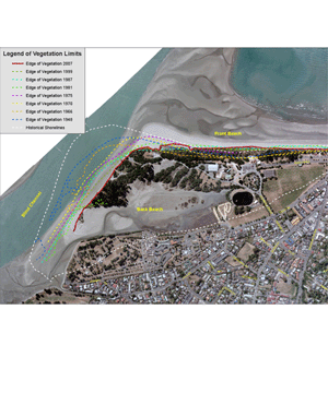
An aerial photo of Tahunanui Beach, showing erosion since 1948 (Nelson City Council)
Erosion of the beach and dunes has been recorded for many years. One consequence of the erosion is the loss of some ecological significance of national value, including rare estuarine tussock and an endemic beetle - known, as the back beach beetle. In 2005 the storm water outlet at the eastern end of the beach was realigned and the seawall modified to absorb the effect of the waves. Stage two saw the dunes being replenished with 9,000 cubic metres of sand and revegetation through a Coast care programme. These combined with a variety other strategies are assisting in the re-establishment of the dunes on the front beach.
A report (Ocel) in 2000 put erosion at the back beach between 3.5m and 6m a year, although in 2010 council staff estimated it had increased to 10-15m a year. Ocel's 2010 report says that the channel and the spit moved 170m in the four years between 2000 and 2004, the last time a water depth survey was done. It says the potential consequences of these changes are significant, and if they continue, it will mean more sediment dumped near Port Nelson's shipping channel, as well as changes to the exposure of the front beach to coastal processes. 250 metres of the western front beach has been also been washed away over the last 60 years. The report also points out that climate change is likely to be another significant issue for the beach in the future.
This has really made me think about what could happen to this lovely beach over the next few decades? What do you think?
Logging requirements:
GZ: no need to go there to answer any questions just a photo opportunity Now take a nice long walk along the beach and back or drive to each waypoint to answer the questions.
WPT 1: Information boards:
Question 1: From Rocks to Sand: How many thousand years ago was Tahunanui Beach formed?
Question 2: From Channel to Playground: How many entries in the competition to rename “The Sands”?
Question 3: Sand Dunes on the Move: Name two techniques for protecting the sand dunes.
WPT 2: Carpark:
Question 4: What do the black words say on the warning signs in the carpark?
WPT 3: Back Beach:
Question 5: What evidence do you see here of an attempt to stop further erosion of the camping ground.
Email the answers to these via geocaching.com - You may log this as a find before hearing back from me. I will contact you if there are any issues with your answers and I will delete any logs if the required email has not been received. As always photos will be much appreciated.