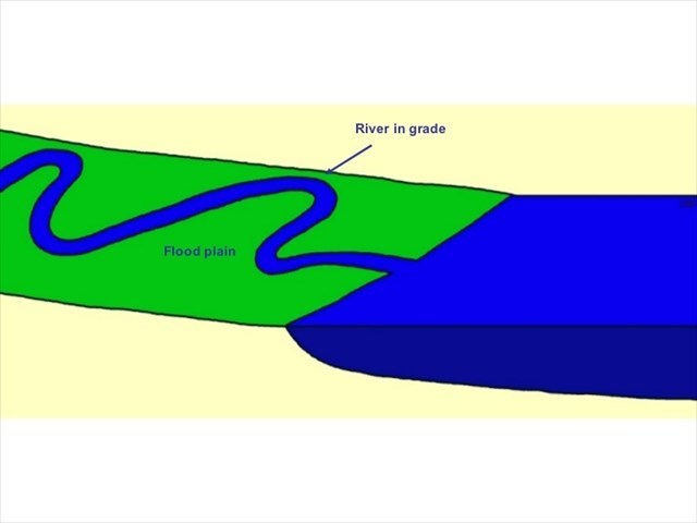
Like most natural things, rivers strive for equilibrium. In a river, the long profile is in equilibrium when it forms a smooth, concave shaped profile without major irregularities, termed a graded profile, which looks something like this:

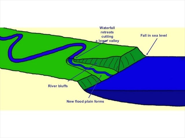
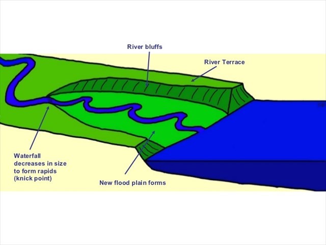
Should the land be uplifted or the sea level lowered, the river will begin to erode downwards in order to re-establish the equilibrium or graded long profile in a process called rejuvenation, which is illustrated below:
1. Graded (Equlibrium) Long Profile

2. Fall in Sea Level triggers Incision of River

3. Further Backward Erosion (Rejuvenation) of River

Most of the rivers along South Africa’s eastern and southern coastlines are rejuvenated as a result of successive cold periods that caused global falls in sea level as ocean water became locked up in ice. For the last 400 000 years generally colder conditions with brief warmer interludes have occurred, resulting in sea levels around southern Africa generally dropping severely. Although sea levels have risen in relatively recent times due to the present warmer conditions, the often dramatic valleys such as this one, formed by rejuvenation, remain. Some of the other more well-known rejuvenated river valleys may be found along the Tugela, Umgeni and Mzimkulwana Rivers in Kwazulu-Natal, the Storms River in the Western Cape and the Great Fish River and Baviaanskloof in the Eastern Cape.
To get to this Earthcache, you are most likely to have descended down into the Great Kei River valley along the N2 from the surrounding plateau region. This route is known as the Great Kei Pass, which was first constructed in around 1955. Road cuttings into the 200-350 million year old Karoo Supergroup rocks will give you an appreciation of what the river had to erode through to achieve its present level.
Now, to claim your find: Simply email the answers to these questions to the cache owner for verification. You are welcome to log your find before submitting your answers, but logs not accompanied by the answers within a reasonable period of time will be deleted.
1. What is the process by which a river will begin to erode downwards in order to re-establish the equilibrium or graded long profile called?
2. Name two causes of the process referred to in Question 1.
3. Looking at the valley floor and Great Kei River bed, would you say the river is currently rejuvenating? Explain why you think this?
4. Use your GPS device to determine the difference in elevation between the valley floor and the surrounding plateau. With this height, calculate by how many millimetres a year (on average) the Kei River would have needed to erode vertically downwards to achieve its present elevation assuming it was originally at the surrounding plateau level 400 000 years ago?
It would be great if you could post a picture of yourself at the location together with your log, but this is optional.

References:
The Penguin Dictionary of Geology; Wikipedia; The Story of Earth and Life.