The posted coordinates will take you to the top of a trail leading down into a quiet wooded hollow below the surrounding landscape. Follow this trail down the hill, and you find yourself in a ravine, at least what feels like a ravine. However, there is no creek or stream to be found at the bottom, just a small wetland area surrounded by steep valley walls on all sides.
Walking south, you will walk uphill across a small rise in the land, and enter another such valley. If you go north, you cross a rise in the land, entering the third small valley. These three valleys are "glacial kettles", created thousands of years ago when the glaciers receded and formed the current landscape of southwest Edmonton.
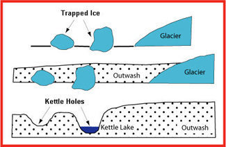
A "glacial kettle" or "kettle hole" is formed when a piece of ice breaks off (or is calved off, to use the proper term) a receding glacier, and becomes buried by the glacial deposit left by the receding glacier. As the ice block melts, a depression is left in the landscape as the surface above subsides into the hole. Greater Edmonton is the part of the Prairie Pothole Region, which extends from Alberta to Iowa, and includes thousands of kettles created by at the retreat of the Wisconsin Glaciation (which ended around 10,000 years ago).
Glacial kettles are often found in areas with "kame and kettle topography", which is apparent in the Riverbend area of southwest Edmonton. You can find a kame
here, about 1 km north (and learn about what a kame is by doing the earthcache!).
Most kettles are circular in shape because melting blocks of ice tend to become rounded; distorted or branching depressions may result from extremely irregular ice masses. The volume of the kettle hole (the size) is generally commensurate with the size of the ice block that created it.
Before this area was developed for a residential neighbourhood, there were four glacial kettles here. The three kettles you have visited were set aside on development as environmental reserve lands. Based on historic maps and City Planning documents, it appears that the fourth was roughly located at N 53° 27.808' W 113° 35.350'. This kettle was filled in with engineered fill to allow residential construction, although as of 2014, there remain at least a couple of empty lots here.
To log this earthcache, e-mail me answers to the following questions. Once you have sent the answers, feel free to log your find. I will notify you only if the answers provided are incomplete or incorrect.
1. Of the three kettle holes here (south, middle, north), which one do you think was formed by the largest block of ice?
2. Estimate the depth of the middle kettle hole. You can use the posted coordinates for this earthcache, and compare to a reading at the bottom of the hole.
3. OPTIONAL: Take a picture of your group your favorite of the three kettle holes. Each one is unique in terms of vegetation, appearance, water, wildlife. Post in your log which of the three is your favorite.
I once saw a moose on the edge of the forest here; not sure how he/she ended up in the area but it is certainly a quiet respite from the surrounding suburbia. Please respect the wildlife in this area and the unique ecosystem that you'll find down here.
References: