Waypoint 1: N 36 38.210 W 121 55.822 A = What's the number, repeated 3 times, in the airplane's identification? Plus 1
Waypoint 2: N 36 38.203 W 121.55.927 B = What day of the month was plaque dedicated? Plus 7
Waypoint 3: N 36 38.238 W 121 56.081 C = In smaller picture, how many sea stars are there? Plus 8
Waypoint 4: N 36 38.224 W 121 56.148 D = Small white sign, how many Black Oystercatchers are pictured?Minus 1
Waypoint 5: N 36 38.131 W 121 56.241 E = Map on the interpretive sign. Number of SMCA plus number of SMR? Plus 3
Waypoint 6: N 36 37.796 W 121 56.239 F = How many Sanderlings in picture on interpretive sign? Minus 1
Cache is hidden here: N 36 37.ABC W 121 56.DEF - substitute the answers above for the letters in the coordinates
By the way, answers for A+B+C+D+E+F = 32
California's Underwater Parks
In December 2012, California became an international leader in ocean protection by completing the United States’ first statewide network of marine protected areas (MPAs). Like the nation’s parks, forests and wilderness areas protect wildlife and habitats on land, MPAs protect and restore unique areas of the ocean. California’s MPAs come in many “flavors”; the size and level of protection, including fishing restrictions, can vary from one area to the next. Also called underwater parks or “Yosemites of the Sea”, they’re designed to protect plants and animals within an entire ecosystem, rather than protecting just a single species and ensure healthy, vibrant ocean life for generations to come.
California’s MPAs safeguard critical ocean habitat, allowing sensitive marine communities such as rocky reefs and seagrass beds to thrive and recover. They also protect biodiversity hotspots and important foraging grounds that support numerous species of fish and invertebrates, as well as seabirds and marine mammals. This in turn benefits a wide range of species including plants like bull kelp, invertebrates like sea stars, and marine mammals such as seals and otters. As safe havens, underwater parks offer a home and refuge for Big, Old, Fertile, Female (BOFF) fish to recover, grow and replenish our ocean.
MPAs are a "network of underwater nurseries"!
The central coast region of California was the first of the four coastal regions to establish a network of MPAs. Underwater parks in the central coast protect areas like the iconic Point Lobos, winding waterways of Elkhorn Slough, the tidepools of Natural Bridges, the elephant seal rookery at Piedras Blancas and many more important marine environments! Altogether, 29 MPAs were designated from Pigeon Point in the north to Point Conception in the south. These MPAs represent approximately 204 square miles (18%) of state waters within the region with approximately 85 square miles (7.5%) designated as "no take" state marine reserves. These MPAs went into effect in 2007.
Explore California's Underwater Parks without getting your feet wet through new online tours!
Based on Google Earth and requires 3D plug in for your browser; follow instructions.
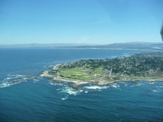
Pacific Grove Marine Gardens (State Marine Conservation Area), Asilomar (State Marine Reserve), Lovers Point (State Marine Reserve), and Edward F. Ricketts (State Marine Conservation Area),
Located next to Monterey and Pacific Grove, these MPAs are some of the most scenic, heavily used and most accessible areas along the central coast. Peninsula includes tidepools teeming with marine life, sandy beaches used by pupping harbor seals, and dense kelp bed habitat for sea otters. 60,000+ scuba divers come each year attracted by the vibrant underwater living treasures.
The rocky intertidal and kelp forest communities of the Peninsula provide a natural laboratory for nearby pre-eminent research institutions: Hopkins Marine Station, Monterey Bay Aquarium, Moss Landing Marine Laboratories.
Pacific Grove Marine Gardens SMCA - from Point Pinos to Lovers Point. Open to recreational finfish fishing and commercial hand harvest of bull and giant kelp. This stretch is less protected for kayaking, but walking path gives wonderful views, and tide pooling at low tide reveals wealth of sea life.
Asilomar SMR - mostly rocky, no-take zone between Point Pinos and Point Joe, Pebble Beach; includes Asilomar State Beach and Spanish Bay. Incredibly beautiful stretch of coast can be seen by car, bike, improved trails, or experienced kayakers.
While you won't necessarily see the following on your walk, they're located a short distance to the east and are certainly worth exploring.
Lovers Point-Julia Platt SMR - along Pacific Grove coast between Lovers Point and the Aquarium. No fishing, all take prohibited but open to kayaks and stand-up paddleboards. A paved recreation runs trail along the shore. Snack shack and kayak/paddleboard, bike and 4-wheel surrey rental. Great little protected beach ideal for kids.
Edward Ricketts SMCA - wonderful stretch of kelp beds and rock gardens along Cannery Row, from Monterey Bay Aquarium to Coast Guard Jetty. Open to recreational hook-and-line fishing only; popular for kayak fishing. San Carlos Beach, near the jetty, is perhaps the most popular dive spot on the peninsula.