You should easily be able to get round the tour in less than an hour - unless you get waylaid by any of the numerous cafes on the route. You then have a walk of just over a quarter of a mile to the cache location itself. The tour starts and finishes near the bus interchange and train station, and there are plenty of pay and display car parks available. If you park on street be careful not to outstay your welcome, as our local traffic warden is very enthusiastic. The whole walk is pushchair and wheelchair friendly, although one of the roads is quite steep up and then down.
Locals could probably work out most of the answers through a combination of local knowledge and Google, but where's the fun in that? The historical "facts" below are mostly nicked shamelessly from Wikipedia, so if you spot any schoolboy errors let me know.
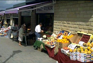
1. N 53 52.346 W 002 23.628 Clitheroe Market. If you've gone to the published coordinates you will be standing in Clitheroe Market. There has been a market in Clitheroe since the 12th Century at least, although it used to be where the library now is, and the present site was redeveloped in 1995 on the site of the old agricultural market - you should be standing in the middle of the bullring. There are some great stalls if you look hard. Market days are Tuesday, Thursday, Friday and Saturday.
Have a look at the lampstand in the middle of the bullring. The number of lamps hanging from it is A.
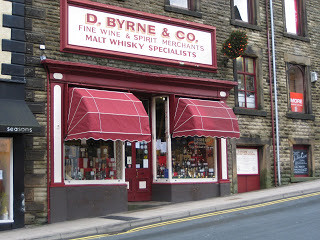
N 53 52.377 W 002 23.513 Byrne’s. This wine shop doesn’t look like much from the outside, but go in and you are in a different world, from the vertigo-inducing ladders for the high shelves to the cellars which extend right underneath the row of shops further up the street. The shop has been in Clitheroe for 130 years and probably looks exactly the same as it did in Victorian times.
Look across the road to the Post Office. The number of postboxes outside is B.
N 53 52.377 W 002 23.447Clitheroe Library. This is the original site of Clitheroe “Moot House”, the local court. Evidence for this comes from the fact that the original dungeon is still inside, next to the library work room! The Library was built, like many others, with funds from the American industrialist and philanthropist Andrew Carnegie.
Look at the plaque on the front. The Library was built in 190C.
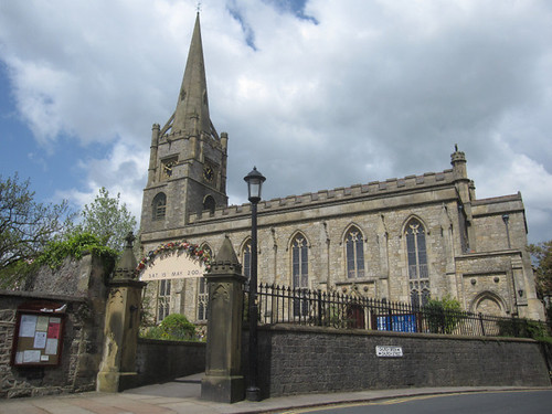
N 53 52.443 W 002 23.421 The Church of St Mary Magdalene. There was a church on this site by 1122, although the oldest parts of the existing building are from the 15th Century. It was heavily “improved” by the Victorians, and the church you see today is essentially 19th Century. The spire was completely removed and then reinstalled in 2012 as the iron brackets used to hold the stones together were so corroded that it was in danger of becoming a hazard to those walking underneath. It is worth looking around for the grave of Thomas Southworth, who met a particularly untimely end. His grave is near the entrance to the church which you will see in front of you. The vicar is a geocacher, so if you see him be sure to say hello.
You know when it was built, but when was it restored? The year is 198D.
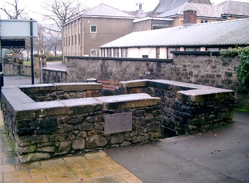
N 53 52.503 W 002 23.349 St Mary’s Well. This rather odd structure was one of the wells which served Clitheroe up until the mid 1850s when piped water was brought to the town. I guess the population of the town was much smaller then, as it swelled massively during the 19th Century with the increasing importance of the cotton industry. In 1891 there were 13 cotton mills in Clitheroe. Much of the housing you will see dates from this period, and has much in common with terraced housing throughout East Lancashire.
This was not the only well in Clitheroe – in fact there were E of them in total.
 N 53 52.463 W 002 23.267Clitheroe Royal Grammar School. The school was founded in 1554 “for the education, instruction and learning of boys and young men in grammar”. The oldest part of the building you see has been there since 1834, but is actually about 50 years older, having been moved stone by stone from its previous home in St Mary’s Churchyard! This site is now used for the school’s Sixth Form, with the rest of the school at a site about half a mile away on Chatburn Road.
Have a look at the rather grand main school building. The number of arched windows in between the two entrances (not counting the ones above the entrances) is F.
 N 53 52.421 W 002 23.340 The Grand. This is now a state of the art Arts and Music venue, but it was built in 1873-74 as Clitheroe Public Hall. It was converted to use as a cinema (“The Grand Kinema”) in 1921, and many of us who have lived in the area for a while will recall fondly its mock-tudor beams, slightly sticky floor, and dodgy projection system.
You might be able to make out some concrete bollards in the photo, but you can’t see all of them. In fact there are G bollards on that side of the road.
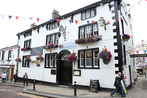
N 53 52.322 W 002 23.514 The Swan and Royal. This is one of Clitheroe’s most historic hotels. Famous guests have included Gandhi (while researching the Lancashire cotton industry) and Sir Winston Churchill. However, it is perhaps best known for its role in the birth of the jet engine. Work on this concept was started before and during the war by Sir Frank Whittle. A key deal between Whittle and Stanley Hooker and Ernest Hives of Rolls-Royce was sealed over a meal at the Swan and Royal, leading to the large scale development of the jet engine in nearby Barnoldswick. The hotel was gutted by a fire in 2010, and re-opened in 2011.
Have a look at the blue plaque. Whittle’s meal cost H shillings.
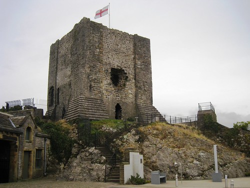
N 53 52.280 W 002 23.545 Clitheroe Castle. No walk around Clitheroe would be complete without taking in the Castle. From the entrance a steep walk up is rewarded by spectacular views over the Ribble Valley, an interesting local museum and a cafe – though please note that to complete this geocache you don’t need to go any further in than you are now! The early history of the castle is quite uncertain, but it was probably built during the late 11th and early 12th Centuries and so is one of the oldest buildings in Lancashire. The castle had a royalist garrison during the Civil War so it is not surprising that in 1649 the parliamentarian government had a hole knocked in the side to make it unusable. Only the keep and curtain wall surrounding it survive – the other buildings surrounding it are much newer.
Look at the benches to the right of the entrance. There are J snake heads under the benches.
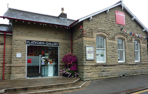
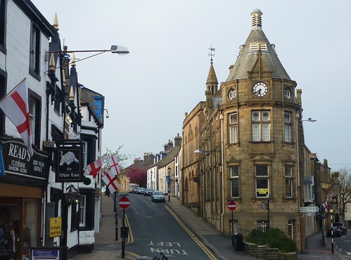
N 53 52.430 W 002 23.632 Clitheroe Station. The original station building now serves as the Tourist Information Centre and as an art gallery, with train tickets sold from a much smaller building next door. The railway links Clitheroe with Blackburn and Manchester to the south and, on Sundays only, to the Settle-Carlisle line to the north. The line was closed to passengers in 1962 “owing to the services being unremunerative” and then reopened after a long campaign in 1994. All we need now are modern trains and a frequent and reliable service...
If you look outside the new station you will be able to read about a very long walk. The length of the walk is K0 km.
You should now have 10 letters in total.
You can find the cache at N 53 (A+2)B.(C-1)(D+3)(E-3) W 002 (F-3)(G-2).(H-5)(J-2)(K+1)
The location is close to the station but feels distinctly rural.