|

 La primera version de este multicache tuvo una vida muy corta. Esperamos que esta nueva version dure mas tiempo. La primera version de este multicache tuvo una vida muy corta. Esperamos que esta nueva version dure mas tiempo.
Si queréis dar un paseo por el Pueblo de Barajas y conocer algunos de sus lugares mas emblematicos, aunque no estén todos, os recomiendo realizar la búsqueda de este multicache. Para ello deberéis seguir un recorrido de varias etapas por el barrio e ir recogiendo las correspondientes pistas para conseguir las coordenadas finales.
Consta de 4 etapas más la localización final.
La distancia que tendréis que recorrer desde la primera etapa hasta el cache será de 1,3 kms. aproximadamente.
 The first version of this multicache had a very short life. We hope this new one lasts longer. The first version of this multicache had a very short life. We hope this new one lasts longer.
Take a walking tour of the town of Barajas and enjoy some of the more interesting locations here. For your enjoyment, I hope that will you take some time to look for this fun, 5 stage multi!
From the posted coordinates, go to each stage around the district collecting the necessary pieces of information to be able to find the final stage. The distance you will walk from the first stage to the cache is approximately 0,8 miles.
0) Introducción / Introduction
Aunque la fundación del pueblo de Barajas puede ser de época romana el origen de su nombre es claramente árabe. El término Barajas proviene de 'Bar-Axa', término árabe que significa 'hija de Axa'. En 1575 se llamaba Baraxas y antes se llamó Bar Axa. El nombre es corrompido de dos dicciones diferentes, una hebrea y otra arábiga, las cuales se exponen y declaran. Bar Axa, id est filius Axe y entre muchas personas antiguas y curiosas de esta villa se ha tenido por común opinión y cosa cierta, que en tiempos que los moros ocuparon a Castilla, fue señor de este pueblo un señalado moro, llamado Baraxa, y por ser hijo de una mora llamada Axa puso su nombre al pueblo.
  Although the origin of Barajas may be Roman, its name is clearly Arabic. The name Barajas comes from "Bar-Axa", the Arabic term that means "daughter of Axa". In 1575 it was called Baraxas and before that, Bar Axa. The name is a rough translation from two different languages, one Hebrew and the other Arabic. Both were combined and became Bar Axa, id est filius Axe. Among the ancient and curious people of this town it has been taken as common opinion and fact; that in the times when the Moors occupied Castile, the lord of this town was a marked Moor, called Baraxa." Although the origin of Barajas may be Roman, its name is clearly Arabic. The name Barajas comes from "Bar-Axa", the Arabic term that means "daughter of Axa". In 1575 it was called Baraxas and before that, Bar Axa. The name is a rough translation from two different languages, one Hebrew and the other Arabic. Both were combined and became Bar Axa, id est filius Axe. Among the ancient and curious people of this town it has been taken as common opinion and fact; that in the times when the Moors occupied Castile, the lord of this town was a marked Moor, called Baraxa."
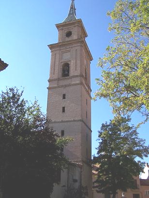
1) Iglesia de San Pedro Apóstol / San Pedro Apóstol Church
(N40 28.469 W3 34.669)
Está ubicada en el corazón del Casco Histórico de Barajas a escasos metros de la Plaza Mayor. Su origen medieval, posiblemente del siglo XV, si bien se puede suponer que ésta iglesia fue construida sobre los cimientos de la más antigua denominada de San Pedro de Antioquía, vórtice de la creación de la villa de Barajas durante el Medievo. En el edificio de la iglesia se adivinan dos etapas constructivas diferentes: la tipología mudéjar propia de la tradición castellana del bajo Medievo y la correspondiente a la renovación del templo con la construcción del transepto y la capilla mayor en la primera mitad del siglo XVI.
En la fachada donde se especifican las coordenadas hay una placa ¿A cuantas personas esta dedicada dicha inscripción? = A
¿Cuantas letras tiene la ultima palabra? = B
It is located in the heart of the Historic Center of Barajas, situated a few meters from the Main Plaza. It can be assumed that this church was built on the foundations of an older one known as San Pedro de Antioquia, a remnant of the creation of the villa de Barajas during the Middle Ages. Inside the church building loom two different types of construction: the typology of the mudejar Castillian tradition of the low Middle Ages and the corresponding renovation of the temple with the construction of the transept and chancel in the first half of the XVI century.
On the wall where the posted coordinates take you, there is a plate. How many people are dedicated in the inscription? = A
How many letters are in the last word? = B
2) Plaza Mayor / Main Plaza (N40 28.421 W3 34.650)
D. Francisco Zapata de Cisneros y Ossorio, nombrado Conde de Barajas por Felipe II en Octubre del 1572, realiza una transformación urbana del núcleo de la villa. La construcción de una casa solariega, que tendría la condición de palacio, cerraba por el sur la antigua plaza de la villa donde se hallaban tanto la iglesia como el ayuntamiento. Es a partir de uno de los laterales de esta casa desde donde se planea la construcción de una gran plaza rectangular. "Su construcción mediante soportales también es un rasgo común a otras villas o ciudades que durante el siglo XV dispusieron estos elementos en las plazas de mercado simplemente como nuevas crujías añadidas a los edificios allí existentes. Podría ser este el casode Barajas, donde los soportales rompen la estructura del callejero alterando la continuidad de las calles, Botica y Anguita, a las que se accede a través de ellos.
En el centro de la plaza, coincidiendo con las coordenadas de esta etapa, hay una fuente ¿Cuántos chorros tiene la fuente? = C
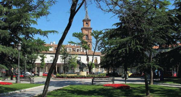
D. Francisco Zapata of Cisneros and Ossorio, appointed Conde de Barajas by Felipe II in October 1572, performed a transformation of the urban core of the villa. The construction of a manor house, which would have had the status of a palace, closed in on the south. The old Plaza de la Villa is where they were both the church and the town hall. It is from one side of this house that you see a large rectangular square. Construction of arcades is also a common feature of other villages or cities built during the fifteenth century. They had these items in the market places as new corridors were added to the existing buildings there. This could be the case of Barajas, where the arcades break down the structure of the streets, Botica and Anguita, by altering the continuity of them. Two of the buildings can even be accessed through the arcades.
In the center of the square, coinciding with the coordinates of this stage, there is a fountain. How many jets does the fountain have? = C
3) Recintos Feriales / Exhibition Center (N40 28.224 W3 34.694)
El llamado Recinto Ferial del Pueblo de Barajas es una explanada situada en el barrio del casco historico entre la calle Ayerbe y los viejos depositos del aeropuerto, que entre diario se utiliza como parking gratuito y los sabados se transforma en un mercadillo generalist Ademas dicha explanada se utiliza para albergar algun que otro mercadillo mas y para las fiestas locales.
En las coordenadas indicadas hay una señal de tráfico. ¿Cuántos números distintos de cero tiene la señal? = D
The Exhibition Center in the village of Barajas is a plaza located in the historic area of the town. It is between the Ayerbe street and the older fuel tanks of the airport. This area is used daily for free parking. On Saturdays, it turns into a street market. In addition, the esplanade is used to host the local festivals.
At the indicated coordinates there is a road sign. How many non-zero numbers does the plate have? = D
4) Ermita de la Soledad / Soledad Hermitage (N40 28.074 W3 34.911)
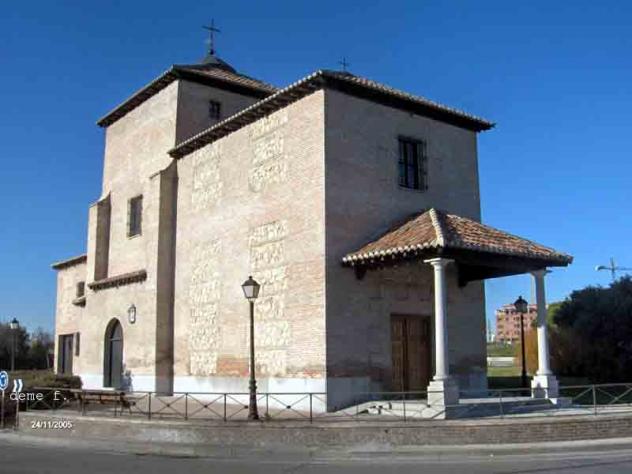 La Ermita de Nuestra Señora de la Soledad es fiel representante de la extensa red de capillas, ermitas y humilladeros que salpicaban Castilla en los siglos XVII y XVIII. Esta red ha ido desapareciendo progresivamente debido al incremento poblacional de los municipios donde los edificios se hallaban enclavados, siendo extraño, y por razones singulares, la pervivencia de alguno de ellos en nuestra época. El escaso interés especulativo donde se halla ubicada y su relación con la memoria de Barajas, relacionada con su pasado de producción de cereal, ha posibilitado que la Ermita llegue a nuestros días. La Ermita de Nuestra Señora de la Soledad es fiel representante de la extensa red de capillas, ermitas y humilladeros que salpicaban Castilla en los siglos XVII y XVIII. Esta red ha ido desapareciendo progresivamente debido al incremento poblacional de los municipios donde los edificios se hallaban enclavados, siendo extraño, y por razones singulares, la pervivencia de alguno de ellos en nuestra época. El escaso interés especulativo donde se halla ubicada y su relación con la memoria de Barajas, relacionada con su pasado de producción de cereal, ha posibilitado que la Ermita llegue a nuestros días.
Las coordenadas pertenecen a la entrada porticada de la ermita. En la parte superior del marco de madera hay una pequeña placa. ¿Cuántas letras hay en la fila superior? = E
The Hermitage of Nuestra Señora de la Soledad is a faithful representative of the extensive network of chapels, shrines and humilladeros (religious monuments located at the entrances to towns) that were scattered around Castilla in the seventeenth and eighteenth centuries. This network has been phased out due to the increased population of the municipalities where the buildings were interlocked. However, for reasons unique to the area, many of them still stand to this day.
The coordinates are for the chapel entrance portico. At the top of the wooden frame there is a small plate. How many letters are on the top row? = E
6) Localización final / Final location
Resuelve estas incognitas. Si el resultado fuese de dos cifras pondriamos un cero delante.
Solve these unknown quantities. If any of the results is two-digit number you must put one zero in the first place:
ZZZ = (A x B x D) + (C - E - 1)
YYY = (C + E) + (A x B) - (D x D)
Las coordenadas finales del cache son:
Final coordinates are:
N40 28.ZZZ W3 35.YYY
Necesitareis llevar un boli para firmar
You will need a pen to sign
|