 This location brings you near a short
(5 to 7 foot high) cliff/gully. Be careful moving around the area
and do not add to the erosion.
Pedology is the study of soils. This study includes the
formation, morphology, and classification of soils. Here we will
look at the morphology of soil.
While there are many definitions of soil, soil can be considered
a natural body consisting of layers (horizons) of mineral and/or
organic constituents which differ from the parent materials in
their morphological, physical, chemical, and mineralogical
properties and their biological characteristics
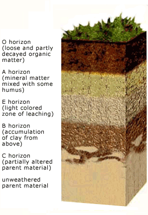
 The soil horizons typically can be easily
identified by their color and physical characteristics. There are
other differences such as pore size and chemical composition, but
they can't be examined without laboratory testing. The horizons are
based on the dominant soil forming process occurring in that layer.
There are six Master Horizons or major classifications of soil
horizons.
These are:
- O – decomposing plant material.
- A – organic material mixed with minerals.
- E – sand and silt particles that are resistant to
decomposition. Typically lighter than the A horizon. Eluviation
(the loss of silicate clay, iron and/or aluminum,
predominates)
- B – accumulation of silicate clay, iron, aluminum,
carbonates, and or gypsum
- C – has not been much affected by soil formation, may
look like the bedrock
- R – Unweathered Bedrock.
Additional lowercase letters and numbers are given to further
describe variations within a Master Horizon. The following link
profides a simplified version of the how the horizons could be
futher described. http://www.petrik.com/PUBLIC/library/misc/aw5_s_layers.htm
or http://www.pedosphere.ca/resources/sg_usa/mhorizons.cfm.
The thickness, presence or absence of layers, and
characteristics of each horizon together make up a soil
profile.
The ocean waves maintain a small cliff exposing a soil profile.
There is no need to do any digging yourself to expose the
profile.
Logging questions:
- The text "GC3BPKM Rodeo Beach Soil Horizons" on the first
line.
- How many people are in your group
- A description of the soil profile exposed in the cliff face,
including the estimated thicknesses of each horizon. (note: you may
not see all the horizons)
The above information was compiled from the
following sources:
- http://www.uvm.edu/place/analyze/soil_horizons.html
- http://www.ncat.edu/~lik/wetland/SoilHor.htm