 />
/>
Langley Wood National Nature Reserve
Langley Wood stands on acid clays, locally overlain by sands and gravels. The varied soils and drainage have produced a rich and diverse woodland and several species of tree and shrub present in this wood are now rare or extinct in the New Forest. Most notable of these is small-leaved lime.
The local plant life includes indicators of ancient woodland such as orpine, Solomon's-seal and southern woodrush. The site also supports many 'old forest' lichens. Five species of deer have been found in the wood, but today the fallow deer have reached pest proportions. Breeding birds such as wood warbler, woodcock and lesser-spotted woodpecker delight the “birders”, and rare beetles and moths feature strongly. Regretably, no dormouse have been seen in recent years.
Management
The reserve is managed by Natural England, who adopted an approach of minimum intervention management, where felling and planting of trees is avoided and dead wood is allowed to rot where it falls, providing habitat for specialist invertebrates and fungi. This is now being amended in a measured way to help preserve threatened species and to acknowledge climatic changes.
A few small conifer plantations in the wood are being converted back to native broadleaved woodland. As the conifer crop is harvested, young broadleaved tree seedlings establish in the cleared areas. It is hoped this natural regeneration should result in the re-establishment of native stands of broadleaved trees without the need for planting.
Research
Valuable information for woodland ecologists and foresters is being collated by studying the natural development of woodland over time in the minimum intervention area. Deer, squirrels, fungi, competition between trees, shrubs and ground flora and the weather are all affecting how the wood develops.
Control of bracken is also being studied. Under some conifer plantations dense bracken is inhibiting the natural regeneration of broadleaved trees. The use of herbicide, a mechanical bracken bruiser and pigs to control bracken and encourage natural regeneration of tree seedlings is being tested in an experimental trial.
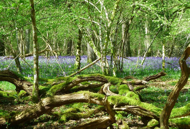
Bluebells in springtime
The Walk
The coordinates (Stage 1) are for the entrance to the wood at Gate 1 where there is a small parking space. Please park considerately as muggles come and go with their dogs. You will see the Natural England sign with a map of the wood. On the back of the sign is the date of an Act which is important for this wood. Note the last two digits as “A” and “B” - you will need them later!
From the entrance, follow the path, named Mary’s Walk after the lady who lived in these woods. You will cross two sections of wooden boardwalk over boggy bits of the path. How many planks do you walk on in the shorter (first) section? Save this as “CD”. You will then arrive at Stage 2 “Right Turn” . Obviously turn right at the new wooden finger post, and follow the waymarked Circular Route to Stage 3 “Junction”
Much of this first part of the walk has been lightly cleared to restore the “outwood” to woodland pasture. Although this may seem at odds with the minimum intervention policy, it will enable the reserve to support a more diverse range of flora and invertebrates. After passing through an ancient earthbank, the path enters the less-managed area. Old coppice stools of small-leaved lime grow amongst hazel, oak and a variety of other native trees. Langley Wood is particularly noted for preserving one of the last remaining parcels of small-leaved lime (The Linden Tree) which was once prolific in England's woodland following the last Ice Age. Perhaps the reason it survived here was the wood being highly desirable for making spindles for the lace-making trade in Downton and the surrounding area?
To the right of the path grows a fine stand of Corsican pine. Old sweet chestnut trees also flank the path. Sweet chestnut is often coppiced to produce wood for fencing and charcoal. Corsican pine is grown for timber. Although these foreign forestry trees support some woodland wildlife, most of the rare species of wildlife found in Langley are associated with native species of tree.
Then the woodland to the right of the path is dominated by alder, growing well in the wetter soils. The flora growing under the alder is also characteristic of damp conditions, forming a luxuriant carpet of ferns and mosses. In spring and early summer a variety of birds including marsh tits, chiffchaffs and robins can be heard singing on the edge of the clearing to the left of the path.
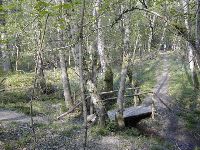
At one point, the path crosses a delightful bridge which replaced the one featured in the first photo in this description. The corner posts supporting the railings have small engravings. Two have the year of construction. Add the last two digits of the year, and save it as “E”. You will also find engravings of two animals. From the table below, make “F” the sum of their values.
Beetle = 1
Deer = 2
Butterfly = 3
Bird = 4
Squirrel = 5
The path is bounded by medieval banks, built to guide commoners’ cattle and pigs when they were moved between commons and copses. These medieval livestock practices were probably based on the usage of the wood since prehistory.
The woodland to the right of the path was cleared of a dense bank of rhododendron in the 1990s. Birch, bracken and foxgloves are among the first plants to colonise the cleared areas. In spring, wood warblers nest on the bare forest floor.
Up The Junction
Our path meets another at an acute angle.
https://img.geocaching.com/cache/0c7ddbdc-2093-4627-a125-3daf2bc1b7a8.jpg?rnd=0.3039815 Count all the yellow arrows on the rustic finger post to find the value of “G”.
For a checksum, use John Buchan’s “The XX Steps” -7.
At this point turn left and follow the Permissive Path towards the final cache location (Stage 4) at:-
N50 59.(B+E)(A-F)C
W001 40.D(E-G)0
To the Cache (at last!)
Some of the Permissive Path has been reinforced with hardcore. This was necessary to enable commercial wood crops to be extracted to support the general conservation work. You will notice a large area on your left that has been fenced off. This area will hopefully be attractive to nightjars, summer migrants that arrive in late April to mid-May. At the end of the Permissive Path, where it meets a public footpath at another finger post, turn right, passing a small pond. Save this point as a Waypoint for your route back to the start, after logging the cache. You are now making a short diversion from the waymarked circular path, but should still follow the public footpath. Just before you leave the SSSI area at the Natural England Information Board, you may notice some bushes on your left which appear to be out of place. If you investigate, you will find the remains of Mary’s cottage, which tragically burnt down. You may find her bed among the wild flowers. The cache is by the footpath just outside the Reserve, to comply with GAGB Rules. The ground around it can be “moist”!

Mary’s Bed
The Way Home
After visiting the cache, retrace your steps to the circular route, and turn right by the muddy pond. When you complete the circuit at Stage 1, follow the Red Arrow on the Finger Post to “EXIT GATE 1”. We hope you enjoyed your tour of our local Nature Reserve, and look forward to reading your account of your visit.
Acknowledgements
Langley Wood is one of a group of National Nature Reserves spread across the whole country. They were established to protect the most important areas of wildlife habitat and geological formations in Britain. This reserve is also part of the New Forest Special Area of Conservation under the European Habitats Directive.
Many thanks to Stuart Hales and the team at Natural England who have provided much information and assistance in the creation of this cache, and to Dave Bennett, the volunteer warden for this wood who put up the new finger posts and is responsible for maintaining the pathways.
The first photograph of Langley Wood is Image Copyright Peter Beaven, and is licensed under the Creative Commons Attribution-Share Alike 2.0 Generic Licence. The others are by the Cache Owners, and those in the gallery have been submitted by other cachers who have enjoyed Langley Wood, as we hope you have.