Stoyoma Mountain is located at the northern extent of the Cascade Mountain Range. The Stoyoma Mountain area is underlain by Late Triassic and/or Early Jurassic granitic rocks assigned to the Mount Lytton Complex. This complex comprises mainly diorite and granodiorite which host local pendants of carbonate rocks of Paleozoic and Mesozoic age.
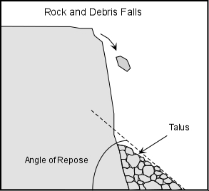
Talus, also called scree, is a term given to an accumulation of broken rock fragments at the base of crags, mountain cliffs, or valley shoulders. Landforms associated with these materials are sometimes called scree slopes or talus piles. These deposits typically have a concave upwards form, while the maximum inclination of such deposits corresponds to the angle of repose of the mean debris size.

The terms scree and talus are often used interchangeably, though scree commonly refers to smaller material like mixed gravel and loose dirt, talus to rocks larger than scree.
Since talus results from falling large rocks or masses of debris the angle of repose is usually greater than it would be for sand.
Talus is created by a process broadly termed, "Mass Wasting". Mass wasting, also known as slope movement or mass movement, is the geomorphic process by which soil, regolith, and rock move downslope under the force of gravity. Types of mass wasting include creep, slides, flows, topples, and falls, each with its own characteristic features, and taking place over timescales from seconds to years. When the gravitational force acting on a slope exceeds its resisting force, slope failure (mass wasting) occurs. The slope material's strength and cohesion and the amount of internal friction between material help maintain the slope's stability and are known collectively as the slope's shear strength. The steepest angle that a cohesionless slope can maintain without losing its stability is known as its angle of repose. When a slope possesses this angle, its shear strength perfectly counterbalances the force of gravity acting upon it.
*Please note that motorized vehicles are not permitted beyond Cabin Lake, so you will definitely need to hike to the site (route would not be possible with a vehicle anyway)
**Cache site is located at approx 6300' elevation so the site can only be visited in late summer/early fall or else the talus will be snow covered. Even in the summer, be prepared for any type of weather. Weather patterns change fast at this elevation so don't be caught off guard.
***Please avoid climbing on the talus slope. The rocks can be very sharp and are held in a very delicate balance between gravity and friction. The additional weight of a person climbing on them could be enough to disturb this balance, creating a slide. It's a long hike back to your vehicle, make it a safe one.
Click here to see an interactive panoramic shot of a meadow along the trail to the cache site.
In order to log this earthcache as a "find" you must email me the answers to the following questions:
1:) What makes this a talus slope and not a scree slope?
2:) What is the average size of the rocks that make up this talus slope? There are a couple exceptionally large and small pieces, but in general approximately what diameter are the rocks.
3:) Estimate the angle of repose for this slope. You can print a degree wheel from the image in the gallery to sight along, or if you have a smartphone with a level app, you may use that to help determine the angle.
4:) What is the type of rock you see in the talus slope? If you do not know its name, describe its characteristics.
Optional task: Please post any photos of this beautiful area with your log.