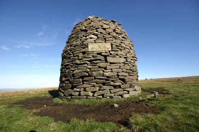
Scout Cairn.
The jewel in the local landscape is Pendle Hill.
It is located in the north-east of Lancashire, England, near the
towns of Burnley, Nelson, Colne, Clitheroe and Padiham. Its summit
is 557 metres (1,827 ft) above mean sea level.
The Scout Cairn is a large beehive shaped cairn, built by local
scouts. There are plaques embedded in the side commemorating 100
years of the Scout movement, and a well known Scout Leader, the
late Dr Hampson. The Cairn can be clearly from the Clitheroe side
of the hill.
A local saying suggests the area around Pendle Hill experiences
frequent rainfall: "If you can see Pendle then it's about to rain,
if you can't then it's already started." When it's not raining, and
there's a usable northwesterly wind, Pendle is a popular
hill-launch for paragliders and hang gliders.
But for you, Pendle Hill is a treasure trove of geocaches
Several caches have been placed on the ‘best’ side
of the great hill for you to enjoy.
I have placed them in a route taking in some of the best views of
the Ribble Valley.
All nearby paths are clearly defined and offer easy access. The
route links with other caches on the hills summit.
Good luck and enjoy the walk.
Haqre ebpxf.