C3 … Cas Cay
Cache is on Cas Cay (pronounced Cas Key) which is
a small island off the south eastern part of St. Thomas. The
western end of the island has a sandy beach for small boats or
kayaks to moor. There is a red-mangrove forest ashore that is home
to a huge village of hermit crabs! (Think Hitchcock’s Birds
but with hermit crabs – really something to see!!) Cas Cay is
a 15 acre uninhabited wildlife preserve which exhibits a special
and rare forest ecosystem including many protected birds, sea grape
and inkberry. There are incredible volcanic cliffs on the south
side of the island and fantastic 360 degree views from the top of
Red Point on the eastern end of the island.
So … how do you get to this cache? First off you need a
water craft and secondly you need hiking boots, sneakers or
possibly “TEVA” type sandals … flip flops will
NOT cut it! (You will be doing some rock climbing.) If you have a
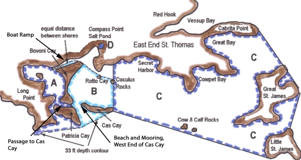
kayak or small boat you can put in at N 18 19.024 W 064 52.495
There is parking here and a small boat ramp. Heading right (west)
out of the boat ramp takes you on a scenic tour through the
mangroves (people power boats only, combustion engines are
prohibited in the mangroves) that ends up turning east and puts you
on a direct course to the beach on the western side of Cas Cay (see
map). If you are putting in a boat with an engine you will need to
turn left off the ramp for a shorter, although not quite as
picturesque, journey (see map).
 Map of Area Around Cas Cay
If you are on-island just for the day (cruise boat passenger)
don’t despair!! Check out kayak or boat renters ahead of time
or E-mail us and we can set you up with some possibilities. We know
people! The commercial kayak tour to Cas Cay will not afford you
time to nab the cache, so you’ll need to get there another
way.
Once on shore at the west end of the island follow the path
along the south side. It will lead you to a cool blow hole in the
rocks that makes some amazing sounds when the waves come and go.
Stay on the path up the hill – at the top you will see a
grassy knoll in the distance – yep that’s where you
will need to go (see pic)!!
 View of where you need to go!
Once at ground zero you will find a bonus!! Two National
Geodetic Survey markers are within a few feet of the cache (see
pics). The one with the triangle in the middle is a Triangulation
Station placed in 1918. The nearby (4.27 meters) Reference Marker
includes an arrow that points to a marker on a nearby island that
the Triangulation Station references. Both of these markers are
listed in the NGS database (last checked in 1973) but unfortunately
are not listed in the Geocaching.com database (yet) … so we
can’t log them as of now.
 Triangulation Marker Placed 1918
 Nearby Reference Marker
While you are sitting on the rock that the 1918 Triangulation
marker is on, check out the view! At a heading of 95 degrees is
Christmas Cove on Greater St. James Island with St. John visible
just behind it (with the numerous houses that sit above Cruz Bay).
At 118 degrees is Little St. James Island and due north is the
Independent Boat Yard.
Don’t forget why you came!? You are looking for a small
Lock-&-Lock container. After finding the cache PLEASE replace
as found so that hurricane force winds won’t disable the
cache. If you are feeling adventurous make your way out to the very
eastern point of the island (see pic). Please post pictures!!
 Exploring the Eastern Most Point of the Island
As always, watch your step, cache safely and enjoy
yourselves!!