


As you explore the trails and parks of the Illinois and Michigan
Canal National Heritage Corridor, you'll become aware of the beauty
and variety of the landscape along the canal route. But you may not
realize that the distinctively shaped hills and ridges, the bedrock
gorges, the marshes, and the lakes are all evidence of the activity
of glaciers and glacial meltwaters. The modern landscape you now
see records the retreat of the last major ice sheet that extended
into Illinois from 25,000 to 14,000 years ago.
The Aux Sable Creek (and its many subsidiaries) flowing just
below your present position was formed by these very same glacial
meltwaters. In fact, a valley carved by glaciers, or glacial
valley, is normally U-shaped. The valley becomes visible upon the
recession of the glacier that forms it. When the ice recedes or
thaws, the valley remains, often littered with small boulders that
were transported within the ice. Floor gradient does not affect the
valley's shape, it is the glacier's size that does. Continuously
flowing glaciers - especially in the ice age - and large sized
glaciers carve wide, deep incised valleys.
Examples of U-shaped valleys are found in every mountainous
region that has experienced glaciation, usually during the
Pleistocene ice ages. Most present U-shaped valleys started as
V-shaped before glaciation. The glaciers carved it out wider and
deeper, simultaneously changing the shape. This proceeds through
the glacial erosion processes of glaciation and abrasion, which
results in large rocky material (glacial till) being carried in the
glacier. A material called boulder clay is deposited on the floor
of the valley. As the ice melts and retreats, the valley is left
with very steep sides and a wide, flat floor. A river or stream may
remain in the valley. This replaces the original stream or river
and is known as a "misfit stream" because it is smaller than one
would expect given the size of its valley.
During the construction of the I & M Canal, the engineers
were presented with a unique problem by the flow of the stream. The
grade of the canal was much higher than that of the stream, so the
decision was made to construct an aqueduct (original image seen
below) so that the canal could flow unimpeded over the stream.
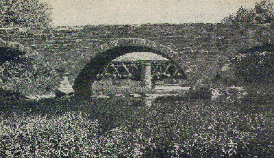
The aqueduct you see now is the second one placed at this
location. The first was erected in 1848 of local limestone from the
Joliet Quarry and local oak wood. This structure lasted until 1933
when it was replaced with a concrete and steel version. Since that
time, the aqueduct has seen a number of improvements, including the
one you see now which was done within the last decade.

THIS CACHE WAS PLACED WITH THE COOPERATION AND APPROVAL
OF
THE ILLINOIS DEPARTMENT OF NATURAL RESOURCES.

1. Geocache is placed on Department managed property with
permission.
2. It is the visitors responsibility to orient themselves with
policies and rules pertaining to this Department managed
site.
To log the cache, please email your answers to the
following:
A) What is the estimated width of the Glacial Valley (or the
length of the aqueduct) from East to West?
B) What is the estimated depth of the Glacial Valley (or the
distance from the bottom of the aqueduct to the stream
below)?
C) What factors influenced the shape and size of the creek
bed in its present condition?
D) Were these factors solely natural occurences, or were they
influenced by man?
E) Based on your observations, does the valley appear to be
more "U" shaped or "V" shaped?
F) Based on your observations (and data from the paragraph
above), do you believe that it was a large or small glacier that
formed this stream bed?
G) Based on your observations, do you see any further
evidence of anything that the glacier may have left behind?
(Glacial Till, Boulder Clay, Steep Valley Walls, etc...)
H) (OPTIONAL) Please take a photograph of you, your team, or
just your GPSr at the posted coordinates with the aqueduct in the
background as proof of your visit.
