The Water Balance [DEU] [ENG] EarthCache
The Water Balance [DEU] [ENG]
-
Difficulty:
-

-
Terrain:
-

Size:  (other)
Please note Use of geocaching.com services is subject to the terms and conditions
in our disclaimer.
ACHTUNG: NIEMAND MUSS DIESEN CACHE MACHEN. UND DIE D2.5 UND T2.5 SIND ERNST GEMEINT. DER EC IST KEIN GESCHENKTER SMILEY. WER SICH ABER DARAUF EINLÄSST, ERLEBT EIN SPANNENDES PHÄNOMEN UND TOLLE AUSSICHT.
Deutsch  |
English  |
EINLEITUNG
|
INTRODUCTION
|
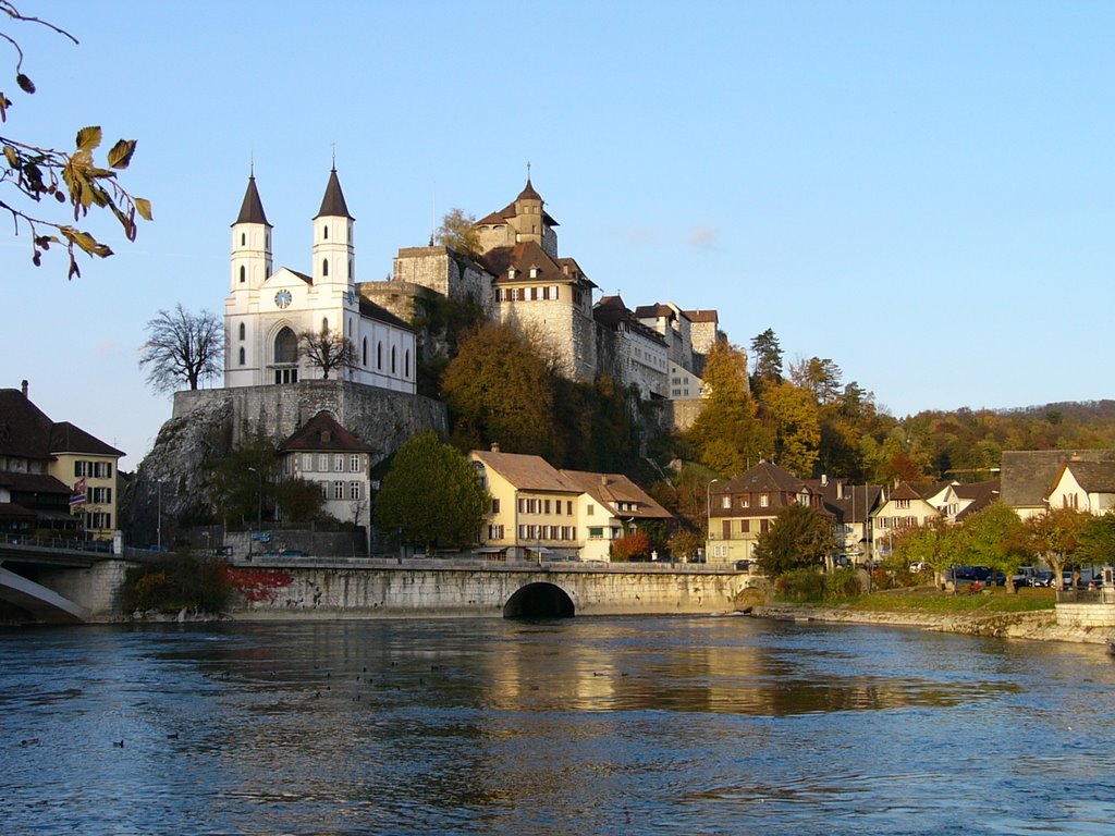
Beim Städchen Aarburg fliesst der Fluss "Aare" rückwärts. Diese Besonderheit ist ein einzigartiges Naturschauspiel, wie man es heute in Europa nicht mehr antrifft. Die Stelle, wo dieses Naturphänomen stattfindet, wird "die Aarewaage", oder in der Lokalsprache "D'Woog" genannt. Sie bildete einst die wirtschaftliche Grundlage des Städtchens.
Bis im 19. Jahrhundert war die Stadt ein wichtiger Hafen: Baumstämme wurden von Aarburg aus zunächst auf der Aare, und dann auf dem Rhein abwärts in die europäischen Schiffswerften geflösst. Auch Wein und Salz wurden in Aarburg umgeschlagen.
Bei diesen Schiffsmanövern gab es spezielle Tücken: Wer die Ausfahrt aus dem Hafen falsch ansteuerte, dem schwammen die Baumstämme einzeln nach Olten hinunter.
Die Eisenbahn als neues und schnelleres Transportmittel konkurrierte die Schifffahrt zusehends. Und seit dem Ende des 19. Jahrhunderts versperren Kraftwerke die Wasserstrasse.
Bei dieser "Woog" wird Treibgut bis zu 300 Meter weit den Fluss hinaufgetragen, manchmal mehrere Male, bevor es den Weg wieder flussabwärts nimmt.
|
In the town of Aarburg the River „Aare“ flows backwards. This special feature is a unique natural spectacle, such is nowadays not met anywhere in Europe anymore. The place where this natural phenomenon is taking place, is called the „Aarewaage", or in the local language "D'Woog“. It once formed the economic base of the town
Until the 19th Century the city was an important port: Tree trunks were initially transported from Aarburg on the river and then floated down the Rhine to the European shipyards. Also wine and salt were traded in Aarburg.
Maneuvering the ships raised special challenges: If the exit from the port was performed in the wrong way the logs risked to float down the river individually.
The railroad as a new and faster means of transport competed more and more the shipping business. And since the end of the 19th Century water power-plants block the waterway.
With this "Woog" debris might be carried up the river, sometimes several times before it takes the path back down the river.
|
Quelle/Source: mapio.net
DAS PHÄNOMEN
|
THE PHENOMENON
|
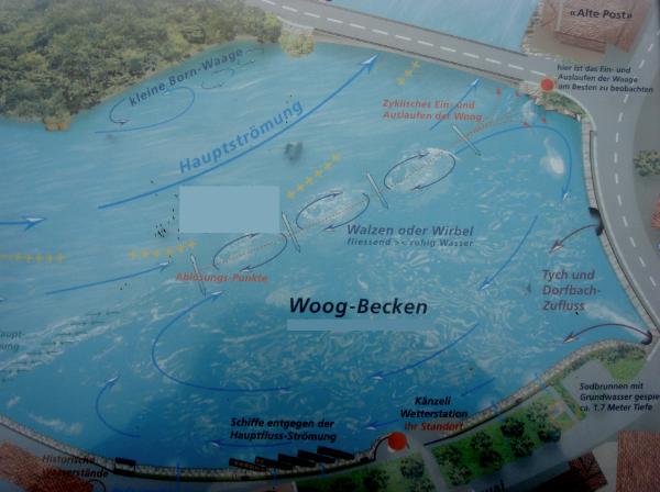
Die Aare wird vom Aarburger Festungsfelsen in ein Knie gezwungen. Mitten im Fluss treffen die starke Strömung und das ruhige Wasser im naturgeformten Hafen aufeinander. Mächtige Wasserwirbel markieren diese Grenze. Das Wasser im Becken wird von ihnen zurückgehalten und flussaufwärts gedrängt. Erst wenn nach ein paar Minuten der Druck zu stark wird, entleert sich das Becken.
Der Wasserstand im Hafen sinkt dann jeweils um ein paar Zentimeter. Verstärkt wird die Gegenströmung von zwei Bächen, die bei der "Woog" (Waage), wie die Aarburger ihr Naturwunder nennen, in die Aare fliessen.
Es sind die Strömungsverhältnisse, welche durch den fast rechtwinkligen Abfluss in nördlicher Richtung, und den Aufprall der Hauptströmung gegen den Felsen des Festungssporns, eine gewaltige Gegenströmung, eine sogenannte Waage oder „Woog“ bilden. Die Ablösung der Wassermassen erfolgt stets in einem bestimmten Zyklus, der sich je nach Wasserstand bemerkbar verändert und das Ein- und Auslaufen der Waage bewirkt. Daher auch der Begriff Waage oder „Woog“.
|
The Aare is forced by the Aarburger fortress-rocks into a kind of knee-bend. In the middle of the river's strong current the water meets the calm waters in the naturally formed port. Powerful whirls mark the limit. The water in the basin is retained by them and pushed upstream. Only if after a few minutes the pressure becomes too strong, the basin gets emptied.
The water level in the harbor then drops each time for a few inches. The counter flow is reinforced by two streams entering at the "Woog" (Balance) into the Aare. It is on one hand these currents that form the nearly perpendicular outflow in a northerly direction, and on the other hand the impact of the main stream against the rock that spurs a massive counter-stream. The release of the water masses is always done in a given cycle, depending on the water level changes and causing the entering and out-flows of the balance. Hence the concept of the balance or "Woog“.
|
Quelle/Source: Display sponsored by Schifferzunft zur Woog
TOURISTISCHE CACHING-EMPFEHLUNGEN
|
TOURISTIC GEOCACHING RECOMMENDATIONS
|
Passend zu diesem EarthCache gibt es noch einen Tradi: GCNW6X 'D'Woog in Aarburg'
|
There is a suitable Traditional-Cache near-by: GCNW6X 'D'Woog in Aarburg'
|
LOG BEDINGUNGEN
|
LOG REQUIREMENTS
|
Beantworte folgende Multiple-Choice Fragen.
1. Aufgabe (freiwillig, beim WP1)
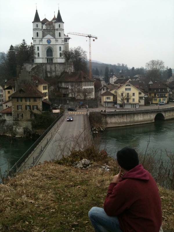
Mache hier ein Foto von Dir mit dem GPS in der Hand, im Hintergrund die Burg, die Brücke und die Aare
Achtung: Der WP1 ist „im oberen Stock“
|
Reply to the following Multiple-Choice Questions.
1. Task (optional, @ WP1)
Take a photo of a) yourself with b) a GPS in your Hand, in the Background c) the fortress and d) the bridge.
Hint: The WP1 is in „the upper floor“
|
[DEU] Muster eines gültigen Log-Foto des FTF-cachers [ENG] Sample of correct log-photo of the FTF-cacher
2. Aufgabe (beim WP1)
Wieviele Betonpfeiler hat es hier? (=X)
Wieviele davon mit Stahlrohr (=Y)
A= X+Y-1
3. Aufgabe (beim WP2)
Gehe nun zum WP2 und lies an der Wanderwegstafel ab wie hoch über Meer wir hier sind.
B=“E“: 395müM
B=“3“: 397müM
B=“H“: 399müM
B=“N“: 400müM
B=“1“: 402müM
4. Aufgabe (beim WP3)
Wie hoch ist der mittlere Wasserstand gemäss der Informationstafel?
C=“C“: 390müM
C=“F“: 393müM
C=“N“: 395müM
C=“H“: 396müM
C=“K“: 397müM
5. Aufgabe (beim WP3)
In den ersten zwei Textspalten auf der Infotafel sind die Worte in verschiedenen Farben geschrieben. Zähle die Buchstaben und Zeichen!
X = Anzahl Zeichen und Buchstaben des ersten Satzes in der ersten Spalte
Y = Anzahl Buchstaben und Zeichen Fett-Schwarz in der ersten Spalte (Der Schlusspunkt ist nicht fett)
Z = Quersumme von X + Quersumme von Y
Jetzt wandle die Zahl Z um in einen Buchstaben nach der Methode A=1, Z=26
D= ....
6. Aufgabe (beim WP3)
Experiment: Wirf etwas biologisch-abbaubares (Ast, Roter Apfel... aber sicher kein Abfall) ins Wasser oder beobachte Gegenstände die bereits im Wasser sind. Wie weit trägt die entgegengesetzte Strömung die Objekte?
E=“K“: Kreist ziemlich genau vor dem Standort in ca. 15 m Radius
E=“L“: Bis zu der nahe gelegenen Baumgruppe
E=“C“: Bis zum braunen oder zum weissen Haus
E=“N“: Bis zum Haus „OLTA AG " oder weiter
E=“X“: Bis zur Brücke
7. Aufgabe (beim WP4)
Gehe zur Mündung des Dorfbaches in die Aare und schaue in den Zufluss. Du siehst mehrere Metall-Stangen die aus der Wand herausschauen. Die wievielte Stange ist näher an der Vorangehenden als die anderen? (Zähle vom Tunnelende)
F=“P“: alle haben den gleichen Abstand
F=“7“: 3
F=“E“: 4
F=“Y“: 5
F=“D“: 6
F=“Z“: 7
Überprüfung und Log-Genehmigung
Mit den gefundenen Angaben kannst Du nun einen Code für einen speziellen Geocoin erstellen und den Coin „discovern“ resp. „grabben“. Wenn Du das erfolgreich kannst, darfst Du auch den EarthCache mit Deinem Foto aus Aufgabe 1 loggen.
Code = (B) (C) (E) (D) (A) (F) |
2. Task (@ WP1)
How-many concrete-pillars do you see on the platform where you are standing? (=X)
How many thereof are with a metal pipe inside(=Y)
A= X+Y-1
3. Task (@ WP2)
Go to WP2 und and read from the yellow hiking signs the indicated hight above sea-level.
B=“E“: 395müM
B=“3“: 397müM
B=“H“: 399müM
B=“N“: 400müM
B=“1“: 402müM
4. Task (@ WP3)
How high ist he average water-level?
C=“C“: 390müM
C=“F“: 393müM
C=“N“: 395müM
C=“H“: 396müM
C=“K“: 397müM
5. Task (@ WP3)
In the first two text colums on the infosign the words are written in various colors. Count the letters and symbols.
Now calculate:
X = Number of letters and symbols of the first sentence in the first collumn.
Y = Number of letters and symbols of the bold black in the first collumn (The '.' is not bold)
Z = crosssum of X + crosssum of Y
Now change the number Z into a letter using the method (A=1, Z=26)
D= ....
In avoidance of doubt: Spaces and the Period shall be ignored)
6. Task (@ WP3)
Experiment: Drop a bio-degradable item (Twig, red apple... – but obviously no trash) into the water or just simply observe items already floating in the water. How far upstream are these items carried?
E=“K“: circles just about infront of your position in a radius of approx 15 meters
E=“L“: To the group of trees near-by
E=“C“: Up to arround the lengthy white house or the high, brown house
E=“N“: To the House marked „OLTA AG“ or further
E=“X“: To the bridge
7. Task (@ WP4)
Go to the Spot where the „Dorfbach“ meets the „Aare“ and look into the pipe. You will see several metal-rods looking out of the side-wall. Count which rod is closer to the previous than all others, beginning with the rod closest to the exit
F=“P“: all have the same distance
F=“7“: 3
F=“E“: 4
F=“Y“: 5
F=“D“: 6
F=“Z“: 7
Check of Answers and Log-Allowance
You have found all answers. With the right answers you can generate the Code of a special Geocoin. You may „discover“ or „grab“ it. If you manage to do this, you may log the cache and upload the photo you took in task 1.
Code = (B) (C) (E) (D) (A) (F) |
[DEU] 22.01., 31.01., 04.04.2010: Listing verfeinert. Alte Listings bleiben gültig. 01.01.2011: Log-Foto ist freiwillig
[ENG] Jan 22, Jan 31, April 4, 2010: Listing refined. Old listings remain valid. 01.01.2011: Log-Photo is optional

Additional Hints
(Decrypt)
[DEU]
JC1: Trur va qra borera Fgbpx
Genpxnoyrf qvfpbirea trug uvre: uggcf://jjj.trbpnpuvat.pbz/genpx/
[ENG]
JC1: Tb gb gur hccre sybbe
Genpxnoyrf pna or qvfpbirerq urer: uggcf://jjj.trbpnpuvat.pbz/genpx/