Weißseespitze, 3518m EarthCache
-
Difficulty:
-

-
Terrain:
-

Size:  (other)
Please note Use of geocaching.com services is subject to the terms and conditions
in our disclaimer.
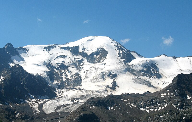
Hike over the Weißsee glacier to the Weißseespitze at 3518 meters above sea level. Great view to the Gepatsch glacier. Takes 3-4 hours one-way from the recommended parking location.
The Gepatsch glacier is the second largest glacier in Austria after the Pasterze glacier. The name stems from the romanic word compaccio, which means “empty field”. The area where it collects snow is bounded in the northwest by the Weißseespitze, and in the southeast by the three Hintereisspitzen. To the north it “leaks” into the Kaunertal, as can be seen on this image from Google Earth.

Together with the Kesselwand glacier it forms the largest connected glacier-covered area in Austria with a size of 18 km². In 1996 the maximal thickness of the glacier was 250 meters. Since 1850 the glacier shrunk by about 50% due to global warming. A hot summer like that of 2003 speeds up this process. The glacier is estimated to lose about 16m in diameter per year. On the way up you will probably see sections of the glacier covered by large white cloth widths. Their purpose is to reflect the sunlight and protect the glacier from further melting.
Glaciers are remainders from the last ice age, the Würm glacial period. During this period, large sections of Europe were covered by glaciers. The Gepatsch glacier had reached it largest size around 1850, a date that marks the end of the so-called “Little Ice Age”, a period dating from the 15th to the 19th century. This period was not a real ice age, but marked a period where the world climate was significantly colder than during the warm middle ages before and than today. Today about 10% of the landmasses of the Earth are covered by glaciers.
Since 2002 there are ideas to use larger parts of the glacier for ski tourism. Many groups like the Austrian Alpine Club are resisting these plans.
The Weißseespitze is one of the peaks next to the glacier and has its own smaller glacier on the other side, the Weißseeferner. On the way up you will be able to admire both glaciers. The current summit cross is located on a rocky section of the peak. This area was covered by ice until a few years ago. When the ice retreated the summit cross could be placed here. Before that, the summit cross was located some distance away on a glacier-covered area.
To log the cache do the following:
- Provide a photo of your GPS device (and, if you want, of yourself) at the summit cross.
- Provide a photo of the Gepatsch glacier, on which its large diameter can be seen.
Also, answer the following question via mail:
- Estimate the height of the rocky part where the summit cross is located today.

Warning: You will walk over a glacier. Use crampons and an ice axe. Go in a rope team, there are crevasses.
Warnung: Du bewegst dich über einen Gletscher. Benutze Steigeisen und Pickel. Gehe als Seilschaft, es gibt Spalten. |
|
|
Honest & critical logs welcome!
Honest, and if necessary critical, logs are welcome here. That helps me as the cache owner to know if there ever is a problem with the cache, and it helps other cachers to determine whether this cache will be to their liking. Flattering the owner is neither necessary nor welcome. Favorite points are not expected and I am, in fact, completely indifferent to them; if you award them you do so purely as an orientation to other cachers. Thank you!
Additional Hints
(No hints available.)