Earthworks | Supercontinents EarthCache
Earthworks | Supercontinents
-
Difficulty:
-

-
Terrain:
-
Size:  (not chosen)
Please note Use of geocaching.com services is subject to the terms and conditions
in our disclaimer.
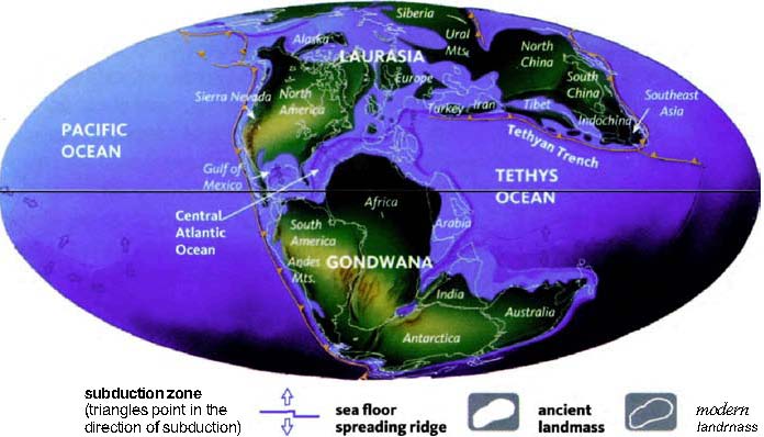
SUPERCONTINENTS
Pangaea, was the supercontinent that is theorized to have existed
during the Paleozoic and Mesozoic eras about 250 million years ago,
before the component continents were separated into their current
configuration.[1]
The name was first used by the German originator of the
continental drift theory, Alfred Wegener, in the 1920 edition of
his book The Origin of Continents and Oceans (Die Entstehung der
Kontinente und Ozeane), in which a postulated supercontinent
Pangaea played a key role.
The breakup and formation of supercontinents appears to have been
cyclical through Earth's 4.6 billion year history. There may have
been several others before Pangaea. The next-to-last one, Rodinia,
formed about 1.1 billion years ago during the Proterozoic era, and
lasted until 700-750 Ma. The exact configuration and geodynamic
history of Rodinia are not nearly as well understood as for
Pangaea.

Rendering of Pangean Supercontinent
When Rodinia broke up, it split into three pieces, the
supercontinent of Proto-Laurasia and the supercontinent of
Proto-Gondwana, and the smaller Congo craton. Proto-Laurasia and
Proto-Gondwana were separated by the Proto-Tethys Ocean. Soon
thereafter Proto-Laurasia itself split apart to form the continents
of Laurentia, Siberia and Baltica. The rifting also spawned two new
oceans, the Iapetus Ocean and Khanty Ocean. Baltica was situated
east of Laurentia, and Siberia northeast of Laurentia.
Around 600 Ma, most of these masses came back together to form the
supercontinent of Pannotia, which included large amounts of land
near the poles and only a relatively small strip near the equator
connecting the polar masses.
About 540 Ma, near the beginning of the Cambrian epoch, Pannotia
in turn broke up, giving rise to the continents of Laurentia,
Baltica, and the southern supercontinent of Gondwana.
In the Cambrian period the independent continent of Laurentia,
which would become North America, sat on the equator, with three
bordering oceans: the Panthalassic Ocean to the north and west, the
Iapetus Ocean to the south and the Khanty Ocean to the east. In the
Earliest Ordovician, around 480 Ma, the microcontinent of Avalonia,
a landmass that would become the northeastern United States, Nova
Scotia and England, broke free from Gondwana and began its journey
to Laurentia.[2]
Euramerica's formation Appalachian
orogeny.
Baltica, Laurentia, and Avalonia all came together by the end of
the Ordovician to form a minor supercontinent called Euramerica or
Laurussia, closing the Iapetus Ocean. The collision also resulted
in the formation of the northern Appalachians. Siberia sat near
Euramerica, with the Khanty Ocean between the two continents. While
all this was happening, Gondwana drifted slowly towards the South
Pole. This was the first step of the formation of Pangaea.[3]

The second step in the formation of Pangaea was the collision of
Gondwana with Euramerica. By Silurian time, 440 Ma, Baltica had
already collided with Laurentia to form Euramerica. Avalonia hadn't
collided with Laurentia yet, and a seaway between them, a remnant
of the Iapetus Ocean, was still shrinking as Avalonia slowly inched
towards Laurentia.
Gondwana and Euramerica separation
It was during these periods of continental shifting and colliding
that the rocks found in High Cliff were formed. Sea levels were
high during the Ordovician period, and if you can imagine the
lakeshore as high at the Red Bird trail you can get some sense of
high much water once existed here. Those early oceans teamed with
life, most of which utilized the high concentration of calcium
carbonate in the water to create their shells, exoskeletons and
bones. Thus after many millenia of calcite-based life cycles, the
ocean floors were rich with lime deposition.
Ordovician Rocks
Ordovician rocks are chiefly sedimentary. Marine sediments that
make up a large part of the Ordovician system consist chiefly of
limestone, because of the restricted area and low elevation of
solid land, which set limits to erosion and resulted in
accumulation of calicite based sediments. This is also the cause of
the dramatic erosion along the bluffs, since the soft sedimentary
Ordovician limestone erodes easily away leaving the harder Silurian
metamorphic stone behind. You can see evidence of both stone types
along the bluffs.
Silurian Rocks
The continents in the Silurian period remained much as they had
been in the preceding Ordovician period, with approximately the
same areas being subject to flooding by shallow seas. The earth was
relatively tectonically inactive during the Silurian. The
Appalachian Mountains, which uplifted during the Ordovician, were
being eroded. Large coral reefs and algae were abundant, indicating
that warm, shallow seas predominated. In North America, the
Silurian ended quietly; however, in the British Isles, Scandinavia,
and France, as a result of the Caledonian disturbance, great
mountains continued to be thrust up. Economic resources of the
Silurian strata, besides salt, are iron ore (near Birmingham, Ala.)
and quartz sandstone, used in glass manufacture. Dominating the
life of the Silurian were marine invertebrates, including crinoids
and cystoids, mollusks, and eurypterids, invertebrates related to
crabs and insects. Members of the trilobite family were still
numerous; primitive fishes increased in number. Also notable in the
Silurian fauna were scorpions, possibly the first animals to live
on land and take their oxygen from the air.

Coordinates will bring you to the Upper
trail head of the Lime Kiln Trail. When you reach the bottom of the
steps, proceed about 20 yards south to see the iconic stone.
Explore the bluffs a little, looking for the 2 types of stone.
You'll need to answer a couple questions about the rocks
types.
|
Logging
Requirements:
To complete this Earthcache, please provide answers to the
following questions.
A. How long do you
think the column of rock in the picture has been
standing this way, hundreds, thousands or millions of years?
B. Find a piece of Ordovician limestone and describe it's
color and hardness.
C. Find a piece of Silurian sedimentary stone and describe
it's color and hardness.
|
References
1. Plate Tectonics and Crustal Evolution, Third Ed., 1989, by Kent
C. Condie, Pergamon Press
2. Stanley, Steven (1998). Earth System History. USA. pp.
355–359.
3. Stanley, Steven (1998). Earth System History. USA. pp.
386–392.
4. The Columbia Electronic Encyclopedia, 6th ed. Copyright © 2007,
Columbia University Press.
Additional Hints
(No hints available.)