What's An Esker?
The word esker comes from an Old Irish word for "ridge." Eskers
are a type of glacial landform, thought to be formed by sediments
left behind by streams of meltwater inside retreating glaciers.
These sediments build up inside tunnels of ice within the glacier
and when the ice disappears completely, a ridge of stratified
sediments - sand, gravel, even boulders - remains. The size and
shape of eskers varies from one to the next, and can provide clues
about the speed and direction of a glacier's retreat. Though eskers
are naturally occurring, they often resemble man-made rail beds and
roadways.
Formation and Special Features of the Vars-Winchester
Esker
The Vars-Winchester esker runs approximately north to south,
passing near or sometimes beneath many local communities like
Sarsfield, Embrun, Vars, and Winchester. A map of the esker can be
seen below.
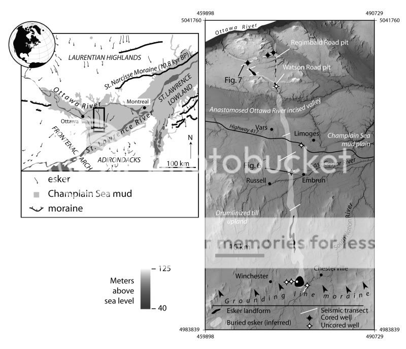
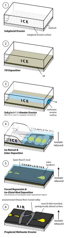
Like most other landforms in the Ottawa area, the esker is a
vestige of the Wisconsin glaciation. While it was formed in the
usual way, it was later covered by mud deposited in the Champlain
Sea following the retreat of the glacier. Because of this, there
are only a few places where the esker is visible at the earth's
surface.
Because the Vars-Winchester esker is composed of permeable sand
and gravel and is, to a large extent, buried by Champlain Sea mud,
it is an excellent aquifer. Many of the communities along it rely
on it as a source of clean water. The esker is currently being
mapped to better ascertain its size, shape, and internal
composition. This will help better understand the groundwater
resource, and sustainably manage it for years to come.
Finding and Logging the Earthcache
The Earthcache coordinates will bring you to the Watson Pit, an
active quarry operation on the esker. From this roadsite point, you
can see the esker - both "inside" it, where it has been excavated,
but also undisturbed portions in the distance. From the site, you
should be able to get a sense of the esker's elevation compared to
the flatter, lower land around it. Looking at the quarry site, you
can see evidence of the materials that form the esker - stratified
layers of sand, gravel, and stone.
Logging Requirements:
You can complete this Earthcache using the information provided
on the cache page, and by visiting the site. Use your own mind -
not Google - to respond! Send your responses to me by email - don't
post them to your log.
1. Note the elevation at the roadside on your GPS.
2. You can see evidence of an active quarry operation at the site.
What characteristics of the esker lend themselves to this land use?
Consider the information listed above, and what you can see in
front of you.
3. The esker is an important source of drinking water for
surrounding communities. Can you think of a way (or ways) that
water quality could be threatened by this, or other land use on or
near the esker? You don't need to do web research for this question
- just look at the site and give it a shot!
You may log your find before you hear back from me, but please
make sure you send your responses to me at the same time as you log
the find. You must meet all requirements to log this as a find! If
you work on the Earthcache in a group, each account logging the
find should email their own original responses to me.
Pictures taken at the site are welcome and encouraged!
Special thanks to Don Cummings at Natural Resources Canada
for his invaluable assistance with this Earthcache.
For further information about other topics mentioned in the
cache page, you can follow the links. Here are some nearby
Earthcaches that will teach you about some of the topics mentioned
here:
GC1EXK1 - The Bridgenorth Esker - Located near Peterborough,
ON, this Earthcache will show you a different esker formed at the
end of the last ice age.
GC1FGWD - The Champlain Sea - Located in Gatineau Park, at this
site you can learn more about the ancient sea that left the
Vars-Winchester esker covered in mud.
GC10MZP - Mer Bleue Bog - In the east end of Ottawa, this
Earthcache will teach you about a very different land feature that
resulted from the last ice age.
GC1HVEX - Lemieux's Legendary Leda Landslide - Mud from the
Champlain Sea strikes again, just north of Casselman, ON.
Visit my geocaching blog! geonarcissa.wordpress.com