Le
parcours se fait sur la commune de Carqueiranne (83320). Une partie
à la découverte du village, une autre partie dans la colline. La
première partie est d'accés facile et permet de collecter les
incides. Par contre, la deuxiéme partie, après résolution de
l'énigme, se passe en colline et demande un peu de crapahutage.
j'ai réalisé le parcours avec des enfants de 5 et 10 ans, et ils se
sont éclatés avec l'aide de nous, les adultes. Soyez juste prudent
et en forme. Le parcours évolue entre 0 et 300m
d'altitude.
un sentier
tortueux
Le lieu peu connu où je
vous emmène aujourd'hui appartient au passé. Dans le temps, ce fut
un endroit cultivé et exploité pour la fabrication de la chaux. La
nature a depuis repris tous ses droits. La grotte où nous allons
fut naturelle (cavité calcaire) jusqu'à nos jours et fut agrandie
par les allemands pendant la guerre pour en faire un poste
d'observation et d'abri. D'où la necessité de prévoir
une lampe. Lors de ma dernière visite j'ai
pu observer des araignées cavernicoles au fond à droite de la
galerie principale.
le parcours pour atteindre
ce lieu va vous être donné à travers une série de waypoints à
suivre et obtenu en calculant un code unique. ce code est obtenu à
travers 5 questions qui peuvent être résolu en se fiant au lieu,
personnes et indications marquées sur des panneaux ou batiment
autour de vous.
N 43° 05.689 E 006° 04.501
le blason
Question A:
les tours sur le blason signifient qu'il s'agit:
- d'une commune faisant partie avec deux autres, d'un cantons
A=10
- d'un village qui est une station balnéaire A=20
- d'un chef lieu de canton A=30
- d'une ville et non d'un village A=40
N 43° 05.648 E 006° 04.501
...encore un blason !
Question B:
Le blason au niveau du toit de l'école jules ferry est celui
de:
- la commune de Hyeres B=100
- la commune du Pradet B=120
- la commune de la Crau B=140
- le vieux blason de Carqueiranne B=160
N 43° 05.692 E 006° 04.587
L'église Sainte Madeleine
Relever la date de la fondation canonique sur la façade.
C= date
N 43° 05.208 E 006° 05.101
chapelle saint Vincent
Question D:
jusqu'en 1880 (date de sa destruction), une chapelle Saint Vincent
existait sur la commune de Carqueiranne, et datait du milieu de
l'époque médiévale.
Dans quel quartier se situait la chapelle:
- les Roubauds D=60
- les Plaines D=90
- Beau Rivage D=120
- Le Pradon D=150
N 43° 05.317 E 006° 04.242
la grande bastide
Question E:
le quartier de la grande Bastide est un des plus ancien lieu-dit de
Carqueiranne, il a même hébergé un temps la mairie provisoire de la
commune. l'endroit comporte un arbuste emblématique de ce terroir.
Il s'agit d'un:
- câprier E=100
- pistachier lentisque E=200
- chêne kemès E=300
le code unique:
X=A+B+C+D+E
les différents coordonnées
a reporter sur la petite carte fournie ci joint et à reporter dans
le gps:
PKG = N43° 06.X-1796 et E6°
005.X-2072
STG1=N43° 06.X-1738 et E6°
004.X-1322
STG2=N43° 06.X-2032 et E6°
004.X-1707
STG3=N43° 06.X-1963 et E6°
004.X-1788
STG4=N43° 06.X-1986 et E6°
004.X-1845
GROTTE=43° 06.X-1987 et E6°
004.X-1899
RETOUR=43° 06.X-1969 et E6°
004.X-1897
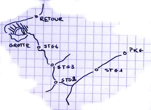
le sentier qui vous mènera
à la grotte chemine à travers une belle végétation. C'est pour cela
que je vous fais aller par cette endroit. Par contre, vous prendrez
le sentier de retour "RETOUR" moins chaotique pour rentrer à la
voiture. Vous marcherez plein nord et une fois sur la piste, alors
plein Est. Ce petit périple vous fera faire une belle petite rando.
Cette forêt est dense, alors fiez vous aux sentiers et semblant de
sentiers qui existe dans cet environnement.
The
course is made on the municipality of Carqueiranne ( 83320 ). A
part in the discovery of the village, another part in the hill. The
first part is of access easy and allows to collect incides. On the
other hand, the second part, after resolution of the enigma, takes
place in hill and asks little of significant hike. I realized the
course with 5 and 10-year-old children, and they were enjoyed by
means of us, the adults.Be just careful and physical health good.
The course evolves between 0 and 300 meter of
height.
A tortuous path
The little known place
where I take you today belongs to the past. In the time, it was a
place cultivated and exploited for the manufacturing of the lime.
The nature since took back all its rights. The cave where we go was
natural (cavity limestone) until our days and was enlarged by
German during the war to make it a post of observation and shelter.
Where from the necessity to plan a
lamp. During my last visit I was able to
observe cave spiders at the bottom to the right of the main
gallery.
The course to reach this
place is going to be given to you through a series of waypoints to
follow and obtained by calculating a only code. This code is
obtained through 5 questions which can be resolved by trusting the
place, persons and indications marked on panels or building around
you.
N 43 ° 05.689 E 006 °
04.501 the blazon
Question A:
Towers on the blazon mean that it is a question:
- of a municipality being a part with two others, of one cantons
A=10
- of a village which is a sea resort A=20
- of an administrative center of canton A=30
- of a city and not a village A=40
N 43 ° 05.648 E 006 °
04.501 ...another blazon!
Question B:
The blazon at the level of the roof of the school jules ferry is
the one of:
- the municipality of Hyeres B=100
- the municipality of Pradet B=120
- the municipality of Crau B=140
- the old blazon of Carqueiranne B=160
N 43 ° 05.692 E 006 °
04.587 The church holy Madeleine
Find the date of the
canonical foundation on the facade.
C = Date
N 43 ° 05.208 E 006 °
05.101 chapel holy Vincent
Question D:
Until 1880 (a date of his destruction), a chapel Holy Vincent
existed on the municipality of Carqueiranne, and dated the middle
of medieval period.
In which district was situated the chapel:
- Roubauds D=60
- Plains (les plaines) D=90
- beautiful bank (Beau Rivage) D=120
- le Pradon D=150
N 43 ° 05.317 E 006 °
04.242 the big bastide (la grande bastide)
Question E:
The district of big Bastide is one of oldest locality of
Carqueiranne, it even accommodated one time the temporary city hall
of the municipality. The place contains a symbolic shrub of this
soil. It is about one:
- Caper shrub E=100
- pistachier lentisque E=200
- oak kemès
E=300
The only code:
X=A+B+C+D+E
Various coordinated has reporter on the small map supplied this
joins and to put back in the gps:
PKG = N43 ° 06.
X-1796 and E6 ° 005. X-2072
STG1=N43 ° 06. X-1738 and E6 ° 004. X-1322
STG2=N43 ° 06. X-2032 and E6 ° 004. X-1707
STG3=N43 ° 06. X-1963 and E6 ° 004. X-1788
STG4=N43 ° 06. X-1986 and E6 ° 004. X-1845
GROTTE=43 ° 06. X-1987 and E6 ° 004. X-1899
RETOUR=43 ° 06. X-1969 and E6 ° 004. X-1897
The path which will lead
you to the cave walks through a beautiful vegetation. It is for it
that I make you go by this place. On the other hand, you will take
the path of return "RETOUR" less chaotic to return in the car. You
will walk the full North and once on the track of fire (dfci), then
the full East. This small trip will make you a beautiful small hike
do. This forest is dense, then trust you in paths and appearance of
paths which exists in this environment.