The posted coordinates above will lead you to one of five waypoints/clues. You may begin your search at the first clue (indicated below as waypoint A) but it is not necessary as the waypoints may be visited in any order , however The final location is near Waypoint E.
Although many of the clues are visible as you drive past them, some of the clues will require you to leave the comforts of your vehicle.
When you have all the information, use the following to locate the final cache:
N 44°40.XXX W 063°30.YYY
XXX = (A+B+C+D+E) - 2001
YYY = (A+B+C+D+E) - 2298
Checksum - Northing: 29 Easting: 20
The final cache is just off a public walking trail - a short bushwack is required (lots of thorns!). The final cache is now a large ammo can. “First to Find" prize is a Timmy's on me!
THE FINAL WAYPOINT IS NOT WINTER FRIENDLY. IF THERE IS ANY ACCUMULATION OF SNOW IT WILL NOT BE EASILY FOUND. ALL THE WAYPOINTS SHOULD BE NO PROBLEM IN THE SNOW
Click on any of the small photos to see a larger version.
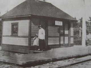
Waypoint A - Cole Wistle Stop
N44 39.438 W63 26.914

The rail line from Dartmouth to the eastern shore became a reality in 1916. It took two years to complete the line across Cole Harbour. The Cole Harbour line continued to Musquodoboit Valley, and transported passengers, lumber, gravel, lime and wood chips, fish and agricultural products. The tiny train station was simply know as ‘Cole Station’, for some reason the word “harbour” was omitted. The fare from Cole harbour to Dartmouth was $0.25 at the start of service, and gradually increase to $2.00. CN discontinued the line in the mid 1980s and the abandoned rail corridor was converted to a rail trails named the ‘Salt Marsh Trail’ & 'Shearwater Flyer Trail' , parts of the Trans Canada Trail.
Waypoint A Clue: What is the Civic Address Posted at the entrance of the trail (West side of road)? _ _ _ = A.
Waypoint B - Cole Harbour Poor Farm
N44 39.846 W63 28.043

Halifax County Poor’s Farm (later called the County Home), was established in 1887 to house the aged, poor and "harmless insane." People who lived on the working farm cared for livestock and grew produce, which was sold to local citizens. The "inmates," as they were called at the time, were housed in institutional-style dormitories. The home closed in 1929, when a large portion of the coed dormitories burned down. No one died in the fire, and residents of the home were transferred to the poorhouse in Halifax. Ten years after Poor’s Farm closed, a rehab centre was built across the road, and then abandoned in 1990's; it has since served as the set for the television show Trailer Park Boys. The building was torn down in 2011.
They waypoint is at the enternce to the park. The remains of the Poor Farm and the poor farm cemetary are located in the park.
Waypoint B Clue: From the Park Information sign, how many acres is the park? Link
_ _ _ = B
Waypoint C - Cole Harbour Meeting House
N44 40.361 W63 28.190

In 1825 the Methodist Chapel was erected, it is known today as the Meeting House and is situated at the top of "Long Hill" overlooking the harbour. In 1961 the old Meeting House was vacated by the church for a new church built nearby on Bissett Road. Special services are still held in this building 2 or 3 times a year. The meeting house has undergone renovations in the 1870's, in 1892 and also in recent years. The meeting house is now owned and preserved by the Cole Harbour Rural Heritage Society.
Waypoint C Clue: From the plaque on the Millstones. What year were the millstones made? Link : 18_ _. C = _ _
Waypoint D - Cole Harbour School House
N44 40.371 W63 28.803

Cole Harbour's first school was opended in July 1814 in a converted sheep barn on the south side of Cole Harbour Rd. The original school was eventually replaced new one room school house, built across the street from the original school. That one room school house operated until it was replaced in the mid 1940's by a larger two room school house that operated until 1965, when it became a community hall, now refered to as "The Box".Link
Waypoint D Clue: What is the Civic Address of the Gray building now located where the original School was?Link _ _ _ _ = D.
Waypoint E - Cole Harbour Heritage Farm
N44 40.353 W63 29.994

The Cole Harbour Heritage Farm Museum sits on a small piece of former farmland now completely surrounded by modern development. It is accessible by city bus and there is no admission. The two hundred year old Giles House was moved to the site in 1976. The site also includes a 150 year old farmhouse, The Harris House, and barns original to the site. The farm houses and barn contain artifacts dating from the 1790's to the 1960's which tell the story of Cole Harbour's agricultural history.
Waypoint E Clue: How many letters in the name of the Barn? (See wooden plaque on side of Barn) Link , ("BLANK Barn")? # of letters in 'BLANK' = E
(sources: Along the Cole Harbour Road (Chapman) & Wikipedia)
Geochecker added July 2011: 
See my other historic multi-cache : Historic Dartmouth Multi

If you are a Geocacher in Atlantic Canada,
please join us. The ACGA is your gateway to
caching in and around the East Coast.