La Cloche Fjord - Baie Fine EarthCache
La Cloche Fjord - Baie Fine
-
Difficulty:
-

-
Terrain:
-

Size:  (other)
Please note Use of geocaching.com services is subject to the terms and conditions
in our disclaimer.
-- THIS IS AN EARTHCACHE, READ BELOW FOR LOGGING REQUIREMENTS --
Welcome to the only non-oceanic Fjord in the world!
Baie Fine is rather difficult to get to, but it is well worth the experience. Unlike more famous Fjords in Scandanavia, Greenland and the west coast, This fjord is unique as it is inland as opposed to oceanic coastal. The surrounding mountains are quartize cliffs, the beauty of the area brings tourists from around the world.
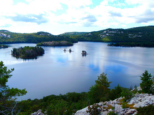
A lake sandwhiched between the two ranges
Fjords are defined as a long narrow inlet with tall mountains on either side. They are generally cut from the surrounding bedrock (or quartzite in this case) into U-shaped valleys by fast moving glaciers pouring into a basin - In this case lake Huron. Some would argue that this is the only true inland Fjord in the world, since it is possible to get here with an ocean ship, unlike the other contenders in New Zealand and Switzerland.

The True Fjord comes only halfway up, dirt left from the glacial retreat defined the lakes and islands further up
The Mountains surrounding the fjord are part of the La Cloche Mountain range and are primarily 3.5 billion year old White Quartzite, laced with 1.5 billion year old pink granite hills and mounds. The mountains were once 11 kilometers tall and made of sandstone; as a comparison, Mount Everest is a mere 8800 meters! The immense weight of the mountain Crushed and heated the below layers into Quartzite - a very weather and chemical resistant rock. It is much more resistant to weathering then the pink red and black granite outcroppings of the area, which is why many of the mountaintops are bare rock - they simply cannot support the root systems and soil. The last 3 billion years of erosion have cut down the mountains into smooth quartzite ridges bordering the Fjord. These ridges make up some of the tallest mountains in Ontario.

"Dirty" Quartzite colorations occur when minerals mixed in
Many of these mountains have large megalithic boulders on top, which were used as "warning bells" by the local natives when struck. The french voyageurs named the mountains the Bell mountains (la cloche in french).
LOGGING REQUIREMENTS:
The posted coords are just a reference, logging requirements can be done from anywhere in the fjord from Georgian bay to Killarney lake.
- Make your way to a peak either on the north side of the Fjord (facing South), or the south side facing North. Take a picture of yourself with your GPS, and jot down the coordinates, and the elevation. Include these with your found log as well as a description of how you got to the area.
- email me a brief description of the vegetation and soil composition of the lowlands (or baie islands) vs the highlands. Include a reason as to why you believe this to be the case. You must visit both the highlands and the lowlands! Requires steep climbing on rocks, so be very careful in wet weather!
- email me a brief description of why you think the water is the colour that it is, and what makes it that way

White Quartzite peaks
SUGGESTED ROUTES:
If you plan on doing this you will need to plan for atleast 1 day travel. Bring water and food. Despite the clarity of the water of the lakes they are quite acidic due to acid rain from the 1970s, and i would advise against drinking it. If you want some help planning I know the area fairly well and would be happy to help plan a route with you.
BY BOAT: Very easy - Charter or sail from Small current harbour on manitoulin island up into the Fjord.
By Canoe: Moderate - Canoe from the town of Killarney North, to the South ridge of the mountains, climb up and over the ridge.
By Canoe: Hard - Canoe George Lake Campground, multiple portages. Get to Killarney Lake and choose your mountain!
By Hike: Hard - Head east along the La Cloche Trail from the George Lake campground - round trip will take approximately 9 hours

Click the logo to visit the COG website!
Additional Hints
(No hints available.)