PLEASE NOTE that Earthcaches require the proper completion of Logging Requirements before they can be logged as "Found". The Logging Requirements are listed below. Failure to email or message the cache owner with the answers will result in your log being deleted. We look forward to hearing from you!
GENERAL INFORMATION
The posted coordinates will bring you to a map just inside the Gaetz Lakes Sanctuary in Red Deer, AB. Access to the Sanctuary is through the Kerry Wood Nature Centre (no entrance fee, not even if you wander through the displays, gallery or book store). After hours you can enter through the Imagination Grove/Harmony Garden at the north end of the Nature Centre. This is a bird and wildlife sanctuary so please leave your dog behind, stay on the trail, and no jogging or bicycles are allowed. Also note that there is no street access from 67 St/Hwy 11. RV parking and a bicycle rack are available.
The Nature Center is open:
Victoria Day to Labour Day: 10 am – 8 pm every day
Labour Day to Victoria Day: 10 am – 5 pm every day
Stat holidays: 1 – 8 pm
The Sanctuary is open 24/7 for quiet nature observation. Please leave no trace of your visit and take only memories and pictures.
THE EARTHCACHE
The Gaetz Lakes, located in the Gaetz Lakes Sanctuary, are remnants of an old bend in the river that was abandoned when the river cut its present channel. This type of lake is called an oxbow lake because its U-shape resembles the bow of an ox yoke. In Australia these lakes are called billabongs and in Louisiana they are referred to as bayous.
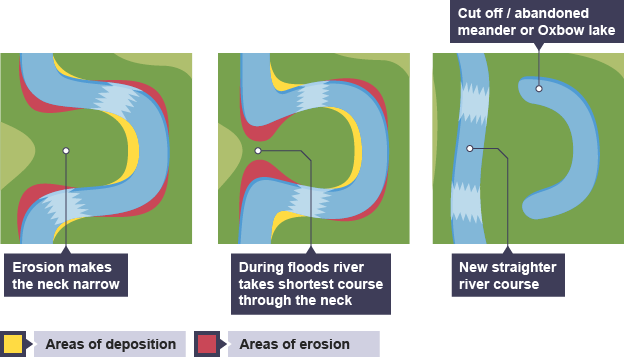
As a river flows across a plain its course begins to curve or meander. The meanders become more pronounced due to river erosion. The water on the outside (concave) bank moves more quickly and cuts away or erodes material from that bank. This material is carried along until it is deposited on an inside (convex) bank where the water is moving more slowly. This continuous erosion of the outside banks and deposition on the inside banks creates an increasingly pronounced meander with two outside banks getting closer together. (See first diagram below.)
The neck of land between the two outside banks grows narrower until the neck is cut through by erosion or during a flood. The river flows both around the meander and along the new straighter channel for a time. (See second diagram below.) Over time, however, sediment is deposited to cut off the old meander channel and an oxbow lake is formed. (See third diagram below.)
Without the river water’s movement, oxbow lakes can become overgrown by plants, fill in with sediment (especially when the river floods) and the water eventually dries up. The oxbow lake becomes a meander scar--a shallow depression in the land. In the case of Gaetz Lakes, springs provide a water source and have kept the lakes alive.
Oxbow lakes are often shallow and create excellent nesting habitat for water birds. Due to the lakes, Gaetz Lakes Sanctuary became Alberta’s first federal migratory waterfowl sanctuary in 1924.
But, why are there two slightly curved Gaetz Lakes, not one bow shaped lake? This oxbow lake formed about 10,000 years ago. Two thousand years later, a piece of land slumped down from Michener Hill on the south and divided the lake into two.
Both lakes are spring fed but the source of those springs makes each lake very unique from the other. West Lake is surface fed which gives the water a very high oxygen content. This environment supports an incredibly diverse variety of species both below and above the water’s surface. In contrast, East Lake is fed by underground springs leaving the water very low in oxygen. Life in the lake water is restricted making this lake less attractive to water birds and other animals.
LOGGING REQUIREMENTS
To log this earthcache, you must visit various spots around the lakes along the Dr George and Wishart Trails, an easy 4 km hike. Start on the Dr George Trail (paved) and watch for the sign directing you onto the Wishart Trail (gravel). Send answers to the following questions to the owner to authenticate your online log. Do not post the answers online.
1. From the bird blind what manmade structure can be seen at water level at the far end of the lake?
2. What is the source of Gaetz Creek (watch for the sign)? From what you've learned from this earthcache information, where does the creek end?
3. What other geological feature is explained by a trailside sign? (See signs at the top of a hill between two slopes with handrails or at an overview of the east lake.)
Thank you to the staff of Kerry Wood Nature Centre for their help and support of this earthcache.
Enjoy your hike!