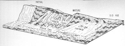
 The coordinates bring you to a large pullout and NPS informational sign. Two dirt roads head off to the north and northeast. Alternately, you can go to an overlook along the Mastodon Peak (N33 44.047 W115 47.917). Personally I think the Mastodon Mine view provides a better view because of its height, but it adds a couple of stars to the terrain rating and does not allow dogs or strollers. At both locations, the pediment is located to the east toward the Eagle Mountains.
 Pediments are wide, gently sloped regions at the base of more steeply sloped desert mountain ranges. Often there is little or no soil on top of the bedrock. While the mechanisms that form pediments have not been determined with certainty, the following sequence of events has been proposed as at least plausible, given the geologic history of the area.
During the last glacial period, a thicker layer of soil covered the area supported by a cooler and wetter climate. However, higher elevations had a thinner layer of soil than lowlands. Subsoil erosional processes worked faster on the bedrock core of the mountainsides eroding back the core, leaving a gently sloped bedrock base protected by a thicker layer of soil. Then, as the glacial period ended and hotter dryer conditions prevailed, the vegetation that stabilized the soils died out. The soils were eroded away, leaving the gently sloped bedrock base called a pediment.
In this theory of pediment formation, bajadas (Bajada – Joshua Tree NP) are visually similar to pediments, however pediments are formed from erosion rather than deposition. There are two features that can help differentiate between a pediment and bajada. First, pediments will likely have common exposures of bedrock sticking up through a thin veneer of sediment while bajadas will not have these exposures. Second, the major drainages of bajadas can be traced back to a few steep narrow canyons that are the source of the material deposited on the surface of the bajada. Pediments will not have these source canyons and erosion will be removing sediment from the entire surface.
 In an alternate theory of pediment formation, a bajada forms along the mountain front first. Then, as the mountain range erodes so much that it no longer supplies sediment to the bajada, the bajada begins to erode down relatively evenly. This results in the broad gently sloping incline up to the bedrock remnants of mountain.
Logging requirements:
Send me a message (preferred) or an email with the answers to the following questions.
- What features can you see that indicate the area is a pediment? Include a quick description of them such as size, color, and number.
- Does the pediment continue to the west?
- Take a picture of yourself or your signature item in front of the sign at the given coordinates.
Please Note:
1. You must answer all the questions in your email to me and post all picture(s) with your log.
2. Your logging this cache and sending me the email should happen at around the same time.
3. Begin your email with the name and geocaching code of this Earthcache, your name(s), and the number of people in your group.
Failure to comply with the above will result in your log being deleted!
The following sources were used to generate this cache:
- Trent, D.D. & Richard W. Hazlett, Joshua Tree National Park Geology, Joshua Tree National Park Association, 2002
- Faulted Structures -- Geology 101 http://www.slackpacker.com/faultedstructures.html
- Encyclopedia Britanica, pediment, http://www.britannica.com/EBchecked/topic/448534/pediment#default
Placement approved by the
Joshua Tree National Park