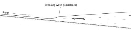
A tidal bore is a phenomenon in which the front of the rising tide propagates up a river as a bore, a churning and tumbling wall of water advancing up the river not unlike a breaking surf riding up a beach.
The rise and fall of ocean tides is caused by the gravitational "pull" of the moon on the earth's watery blanket. At most places along the ocean shores, high tides occur regulary every 12 hours, 25 minutes.
In the open ocean the tide only rises and falls a fraction of a meter. However, in most V-shaped bays and inlets the tide enters the broad end and the water literally "piles up" as it moves up the bay. In certain areas, such as the Bay of Fundy, the natural period of oscillation is very close to the tidal period and, just like water sloshing back and forth in a bowl, the rise and fall of the tide is greatly amplified. Thus, the tide water enters the bay at its widest point, and as it passes along towards the head of the bay, it is in effect squeezed by the ever-narrowing sides and by the constant "shallowing" of the bottom. At the very head of the bay this advancing tide becomes a wave varying from just a ripple to several feet in height, and this wave continues into and up the rivers which empty into the bay. This wave is referred to as a "Tidal Bore". Thus we have the phenomenon of a river changing its flow before your very eyes, created by the tidal wave, or bore, flowing in OVER the outgoing river water.
There are three things you will need to do to claim this cache:
1) take a picture and post it of you and your GPSr with the Tidal Bore or rapids in the background.
Email me the answers to the following two questions
2) What is significant about the Shubenacadie River?
3) The world's highest tide was recorded near here, what is the name of that place?

This cache owner
supports the
Association of Nova Scotia Geocaching
Department of Natural Resources have placed leg traps in the marsh for coyotes, as long as people stay on the trail and keep kids and dogs under control you will be safe.