There are picnic tables, barbecues, grassed area and play
equipment nearby. Dogs are allowed on the beach further to the
north of the site and there is a cafe to the south.
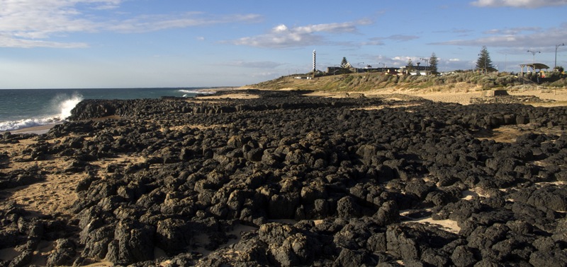
Bunbury Basalt
Why are the rocks black?
The black rock on the beachfront is basalt believed to be part
of a lava flow dating back to volcanic eruptions some 150* million
years ago. The eruptions that lead to this formation occurred as
the supercontinent of Gondwanaland (Antarctica, South America,
Africa, the Indian subcontinent and Australia) started to drift
apart. As the lava cooled it formed into columns giving it a
similar appearance as the Giant’s Causeway in Northern
Ireland. So much so that when Reverend Wollaston drew the map of
Bunbury in 1843 he named this rocky outcrop ‘Giant’s
Causeway’.
The Bunbury Basalt is significant in several ways. Firstly, it
provides evidence supporting the theory of plate tectonics (once
called continental drift). As the plates separated splitting up
Gondwanaland magma welled up onto the oceanic floor resulting in
the formation of the basalt. It is an extremely large flow as it
extends approximately 120 kilometres south to Black Point and well
out to sea to the origin of the flow. This lava flow has a maximum
thickness of 174 meters. The basalt defined the shape of the
Leschenault Estuary and the inlet to the east and created the
natural bar at Point Casurina, which separates Geographe Bay from
Koombana Bay.
What is Basalt?
Basalt is the most common extrusive volcanic rock. Extrusive
means the magma (molten material) flows onto the Earth’s
surface. As the magma cools quickly small crystals form resulting
in the fine-grained appearance of the rock. Basalt is usually grey
to black in colour. Much of the surfaces of the terrestrial planets
Mercury, Venus, Mars and Earth, as well as the Moon, are composed
of basalt. The Earth’s ocean floor is virtually entirely made
of basalt, produced from upwelling mantle below ocean ridges.
Basalt is said to be mafic which means it contains very little
silica, only about 50% by weight. The three essential constituent
minerals are calcium-rich feldspar, calcium- and magnesium-rich
pyroxene and olivine. Olivine comes in magnesium- and iron- rich
varieties.
Why are there columns?
This type of formation is called columnar basalt. During the
cooling of a thick lava flow, joints or fractures form. If a flow
cools relatively rapidly, significant contraction forces build up.
While a flow can shrink in the vertical dimension without
fracturing, it cannot easily accommodate shrinking in the
horizontal direction unless cracks form; the extensive fracture
network that develops results in the formation of columns.
These structures are often referred to as being hexagonal,
meaning six sided. The accuracy of this description is something to
study at the site. The size of the columns depends loosely on the
rate of cooling; very rapid cooling may result in very small
columns with a diameter of less than one centimeter, whilst slow
cooling is more likely to produce larger columns. The columns seen
here are not as well defined as those at other locations. This
could be due to erosion by the seawater.
A bit of local history…
The Old Quarry
This place was a quiet seaside setting likened, by early
settlers to the Giant’s Causeway in Ireland until the late
1890s. Then the area was turned into a huge quarry for extracting
basalt for local road construction.
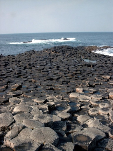
The Giant's Causeway, Ireland
For decades noisy workers set off dynamite at 5pm to loosen
basalt in the quarry to make blue metal for the cobblestones road
base. People would duck for cover as workers, carrying red flags
came on to the streets, signalling blasting was to commence.
The remains of the manmade basalt wall stretching across the
beach in front of us, is all that is left of the barrier created to
restrict natural sand movement and sea surging into the working
quarry. When the quarry closed in 1951 the basalt wall was broken
to allow natural sand movement back into the disused quarry.
Relics of the old pump station once used for pumping seawater
into public baths located to the south of the basalt outcrop can
still be found on the shore. The Bunbury Town Council built the
baths in the 1930s. Large pipes extending from the pump station to
the baths ensured an adequate supply of seawater remained in the
structure during the summer.
To log this cache
1. Send us an email with the following information
a. Name of the cache (we plan on having more than one)
b. Study the shape of the columns. Are they hexagonal? Count the
number of sides on three randomly chosen columns and determine the
average. Send us this information.
c. Did these columns cool rapidly or slowly? What evidence
supports your answer?
2. Take a photo of your GPS (and yourself if desired but not
essential) at this site to prove you have been there and include it
in your log entry. Please avoid including the answers to the
questions in your photo or log.
3. Once you have confirmation from us, go ahead and log your
find and upload the photo.
If you are caching with a number of teams, each team needs to
send in their answers so as to make administering this cache
easier. Log entries that don’t match up with an email of
correct answers will be deleted.
* While the nearby sign states it is 40 million years old,
Geoscience Australia dates the rock at Early Cretaceous. The
Cretaceous Period extended from 145.5 – 65.5 million years
before present. All other publications used when researching the
site support this age of the formation.

baffle